![](/images/other/stat-length.png)
![Excursión Senderismo Pont de Montvert - Sud Mont Lozère - Le sommet de Finiels - Photo](https://media.geolcdn.com/t/1900/400/ext.pjpeg?maxdim=2&url=https%3A%2F%2Fservices.sitytrail.com%2FGeolivesWS%2FDownloadMedia.ashx%3FTrailID%3D129878%26Media%3D13447_3.jpg)
Le sommet de Finiels
tracegps
Usuario
![Longitud](/images/other/stat-length.png)
![Altitud máxima](https://static1.geolcdn.com/siteimages/upload/files/1508320355ic_sort_altitude_max_24dp.png)
![Desnivel positivo](https://static1.geolcdn.com/siteimages/upload/files/1508320355ic_sort_den_pos_24dp.png)
![Km-Effort](/images/other/stat-length.png)
![Altitud mínima](https://static1.geolcdn.com/siteimages/upload/files/1508320355ic_sort_altitude_min_24dp.png)
![Desnivel negativo](https://static1.geolcdn.com/siteimages/upload/files/1508320355ic_sort_den_neg_24dp.png)
![Boucle](https://static1.geolcdn.com/siteimages/upload/files/16400158638029165_repeat_loop_refresh_sync_direction_icon.png)
![Senderismo](https://static1.geolcdn.com/sitytour/trail-icons/101.png)
3h30
Dificultad : Difícil
![Escanee este código QR para abrir la excursión en la aplicación SityTrail](https://capi.geolives.com/qq0zvz2zws4bq2lad0pu/sitytour/trails/129878/qr.png?size=200)
Aplicación GPS de excursión GRATIS
A propósito
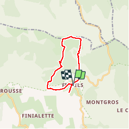
Ruta Senderismo de 10,5 km a descubrir en Occitania, Lozère, Pont de Montvert - Sud Mont Lozère. Esta ruta ha sido propuesta por tracegps.
Descripción
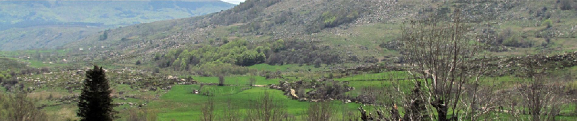
Le départ se situe au hameau de Finiels, à 7km au nord du Pont-de-Monvert. Une agréable façon de découvrir le mont Lozère et le sommet de Finiels. Le chemin serpente dans une forêt de conifères en empruntant le GR70 avant de s'élever rapidement vers le sommet. On bénéficie alors d'un large panorama. Le chemin du retour longe le ruisseau de Prat Souteyrant juqu'au hameau de Finiels; de la, on peut éventuellement poursuivre jusqu'au Pont-de-Monvert par le GR70.
Localización
Comentarios
Excursiones cerca
![Excursión Bici de montaña Cubières - TOUR MONT LOZERE - Photo](https://media.geolcdn.com/t/375/260/a1bfdb58-8337-4d84-b53e-6cb2f940b716.jpeg&format=jpg&maxdim=2)
![Bici de montaña Bici de montaña](https://static1.geolcdn.com/sitytour/trail-icons/202.png)
Bici de montaña
![](/images/other/stat-length.png)
![](https://static1.geolcdn.com/siteimages/upload/files/16400158638029165_repeat_loop_refresh_sync_direction_icon.png)
![Senderismo Senderismo](https://static1.geolcdn.com/sitytour/trail-icons/101.png)
Senderismo
![](/images/other/stat-length.png)
![](https://static1.geolcdn.com/siteimages/upload/files/16400158638029165_repeat_loop_refresh_sync_direction_icon.png)
![Excursión Senderismo Pont de Montvert - Sud Mont Lozère - Bédoues saint jean du Gard GR70 gr43 - Photo](https://media.geolcdn.com/t/375/260/c8a87bd6-9939-4680-8373-9b7fd4cfe94c.jpg&format=jpg&maxdim=2)
![Senderismo Senderismo](https://static1.geolcdn.com/sitytour/trail-icons/101.png)
Senderismo
![](/images/other/stat-length.png)
![](https://static1.geolcdn.com/siteimages/upload/files/16400158638029165_repeat_loop_refresh_sync_direction_icon.png)
![Excursión Senderismo Pont de Montvert - Sud Mont Lozère - Stevenson pont de Monvert/ Bedouès - Photo](https://media.geolcdn.com/t/375/260/ecbe7c42-7ae5-463d-8ef8-0e93073f446d.jpg&format=jpg&maxdim=2)
![Senderismo Senderismo](https://static1.geolcdn.com/sitytour/trail-icons/101.png)
Senderismo
![](/images/other/stat-length.png)
![](https://static1.geolcdn.com/siteimages/upload/files/16400158638029165_repeat_loop_refresh_sync_direction_icon.png)
![Excursión Senderismo Pont de Montvert - Sud Mont Lozère - 13-05-2023 E8 Le Pont de Monvers - Bédouès - Photo](https://media.geolcdn.com/t/375/260/e57cdaa9-bdeb-4cef-90ee-76cf38da3fbe.jpg&format=jpg&maxdim=2)
![Senderismo Senderismo](https://static1.geolcdn.com/sitytour/trail-icons/101.png)
Senderismo
![](/images/other/stat-length.png)
![](https://static1.geolcdn.com/siteimages/upload/files/16400158638029165_repeat_loop_refresh_sync_direction_icon.png)
![Excursión Senderismo Pont de Montvert - Sud Mont Lozère - Finiels/ sommet / station du Bleymard en boucle - Photo](https://media.geolcdn.com/t/375/260/f8048304-3a05-4fd0-a0e7-03457722fcee.jpg&format=jpg&maxdim=2)
![Senderismo Senderismo](https://static1.geolcdn.com/sitytour/trail-icons/101.png)
Senderismo
![](/images/other/stat-length.png)
![](https://static1.geolcdn.com/siteimages/upload/files/16400158638029165_repeat_loop_refresh_sync_direction_icon.png)
![Excursión Senderismo Pont de Montvert - Sud Mont Lozère - J6 Stevenson: Pont de Monvert - Cassagnas - Photo](https://media.geolcdn.com/t/375/260/ext.jpg?maxdim=2&url=https%3A%2F%2Fstatic1.geolcdn.com%2Fsiteimages%2Fupload%2Ffiles%2F1553511878bg_sport_marche.png)
![Senderismo Senderismo](https://static1.geolcdn.com/sitytour/trail-icons/101.png)
Senderismo
![](/images/other/stat-length.png)
![](https://static1.geolcdn.com/siteimages/upload/files/16400158638029165_repeat_loop_refresh_sync_direction_icon.png)
![Excursión Senderismo Mont Lozère et Goulet - sources du tarn - Photo](https://media.geolcdn.com/t/375/260/ext.jpg?maxdim=2&url=https%3A%2F%2Fstatic1.geolcdn.com%2Fsiteimages%2Fupload%2Ffiles%2F1553511878bg_sport_marche.png)
![Senderismo Senderismo](https://static1.geolcdn.com/sitytour/trail-icons/101.png)
Senderismo
![](/images/other/stat-length.png)
![](https://static1.geolcdn.com/siteimages/upload/files/16400158638029165_repeat_loop_refresh_sync_direction_icon.png)
![A pie A pie](https://static1.geolcdn.com/sitytour/trail-icons/100.png)
A pie
![](/images/other/stat-length.png)
![](https://static1.geolcdn.com/siteimages/upload/files/16400158638029165_repeat_loop_refresh_sync_direction_icon.png)