![](/images/other/stat-length.png)
![Excursión Senderismo Esvres - Esvres - Photo](https://media.geolcdn.com/t/1900/400/ext.pjpeg?maxdim=2&url=https%3A%2F%2Fstatic1.geolcdn.com%2Fsiteimages%2Fupload%2Ffiles%2F1553511878bg_sport_marche.png)
Esvres
LEMENIO
Usuario
![Longitud](/images/other/stat-length.png)
![Altitud máxima](https://static1.geolcdn.com/siteimages/upload/files/1508320355ic_sort_altitude_max_24dp.png)
![Desnivel positivo](https://static1.geolcdn.com/siteimages/upload/files/1508320355ic_sort_den_pos_24dp.png)
![Km-Effort](/images/other/stat-length.png)
![Altitud mínima](https://static1.geolcdn.com/siteimages/upload/files/1508320355ic_sort_altitude_min_24dp.png)
![Desnivel negativo](https://static1.geolcdn.com/siteimages/upload/files/1508320355ic_sort_den_neg_24dp.png)
![Boucle](https://static1.geolcdn.com/siteimages/upload/files/16400158638029165_repeat_loop_refresh_sync_direction_icon.png)
![Senderismo](https://static1.geolcdn.com/sitytour/trail-icons/101.png)
2h14
Dificultad : Fácil
![Escanee este código QR para abrir la excursión en la aplicación SityTrail](https://capi.geolives.com/qq0zvz2zws4bq2lad0pu/sitytour/trails/117607/qr.png?size=200)
Aplicación GPS de excursión GRATIS
A propósito
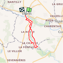
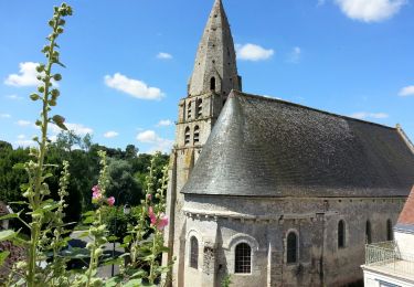
Ruta Senderismo de 9,3 km a descubrir en Centro, Indre y Loira, Esvres. Esta ruta ha sido propuesta por LEMENIO.
Descripción
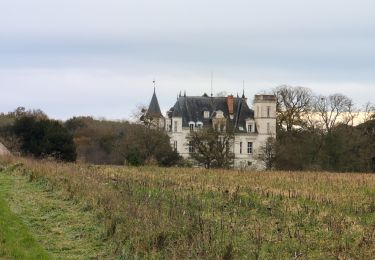
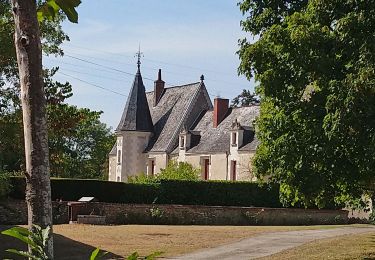
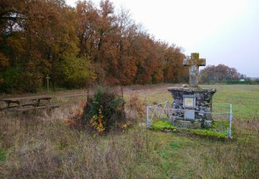
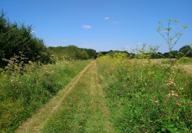
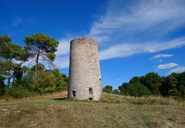
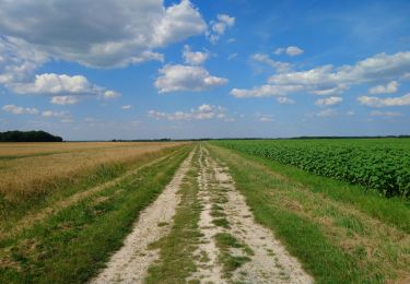
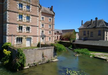
Départ sur la place située derrière la mairie. Ceux qui veulent rallonger le circuit peuvent commencer par une visite de la vieille ville (sortir du parking et prendre les escaliers qui montent vers le château puis faire le tour par les rues sur la hauteur et celles qui redescendent). Deux curiosités sur le circuit : le pont gallo-romain et l'éolienne sans compter les nombreux autres points de vue quand ils ne sont pas cachés par les feuilles des arbres.
Localización
Comentarios
Excursiones cerca
![Excursión Senderismo Esvres - Esvres-sur-Indre - Veneuil Rouillers Hardellière - 24.5km 245m 5h20 (50mn) - 2024 11 23 - Photo](https://media.geolcdn.com/t/375/260/1c4d0998-df48-4940-9f89-ba0d2ada291f.jpg&format=jpg&maxdim=2)
![Senderismo Senderismo](https://static1.geolcdn.com/sitytour/trail-icons/101.png)
Senderismo
![](/images/other/stat-length.png)
![](https://static1.geolcdn.com/siteimages/upload/files/16400158638029165_repeat_loop_refresh_sync_direction_icon.png)
![Excursión Senderismo Veigné - Veigné - les Petits Partenais - 14.2km 130m 3h10 - 2022 08 13 - Photo](https://media.geolcdn.com/t/375/260/12fde0e8-2020-45f1-b53f-7c907a510494.jpg&format=jpg&maxdim=2)
![Senderismo Senderismo](https://static1.geolcdn.com/sitytour/trail-icons/101.png)
Senderismo
![](/images/other/stat-length.png)
![](https://static1.geolcdn.com/siteimages/upload/files/16400158638029165_repeat_loop_refresh_sync_direction_icon.png)
![Excursión Senderismo Truyes - Truyes - La Croix de l'Apothicaresse - 19.9km 125m 4h20 (25mn) - 2021 11 20 - Photo](https://media.geolcdn.com/t/375/260/0174075e-bd77-4474-8448-1ac950f55259.jpg&format=jpg&maxdim=2)
![Senderismo Senderismo](https://static1.geolcdn.com/sitytour/trail-icons/101.png)
Senderismo
![](/images/other/stat-length.png)
![](https://static1.geolcdn.com/siteimages/upload/files/16400158638029165_repeat_loop_refresh_sync_direction_icon.png)
![Excursión Senderismo Esvres - Larçay - le Chêne Pendu GR46 GR655 Veigné Montbazon - 23.2km 230m 5h20 (25mn) - 2021 08 11 - Photo](https://media.geolcdn.com/t/375/260/bef14b6a-df34-48bf-b03d-e33ce373ae61.jpg&format=jpg&maxdim=2)
![Senderismo Senderismo](https://static1.geolcdn.com/sitytour/trail-icons/101.png)
Senderismo
![](/images/other/stat-length.png)
![](https://static1.geolcdn.com/siteimages/upload/files/16400158638029165_repeat_loop_refresh_sync_direction_icon.png)
![Excursión Senderismo Tauxigny-Saint-Bauld - Malabry - Tauxigny chemin des Moulins - 12.4km 160m 3h00 - 2020 09 07 - Photo](https://media.geolcdn.com/t/375/260/c40c54bc-10ff-4748-ba01-f1627c6d4833.jpg&format=jpg&maxdim=2)
![Senderismo Senderismo](https://static1.geolcdn.com/sitytour/trail-icons/101.png)
Senderismo
![](/images/other/stat-length.png)
![](https://static1.geolcdn.com/siteimages/upload/files/16400158638029165_repeat_loop_refresh_sync_direction_icon.png)
![Excursión Senderismo Saint-Branchs - la Fontaine - Saint-Branchs - 14.1km 120m 3h10 - 2020 06 24 - Photo](https://media.geolcdn.com/t/375/260/67f39577-1ed6-43ca-8231-ffcd2999742d.jpg&format=jpg&maxdim=2)
![Senderismo Senderismo](https://static1.geolcdn.com/sitytour/trail-icons/101.png)
Senderismo
![](/images/other/stat-length.png)
![](https://static1.geolcdn.com/siteimages/upload/files/16400158638029165_repeat_loop_refresh_sync_direction_icon.png)
![Excursión Senderismo Veigné - Veigné - boucles via GR46A - 19.9km 210m 4h20 - 2020 05 29 - Photo](https://media.geolcdn.com/t/375/260/a5ad2662-2ed9-425f-8fe1-05da50922710.jpg&format=jpg&maxdim=2)
![Senderismo Senderismo](https://static1.geolcdn.com/sitytour/trail-icons/101.png)
Senderismo
![](/images/other/stat-length.png)
![](https://static1.geolcdn.com/siteimages/upload/files/16400158638029165_repeat_loop_refresh_sync_direction_icon.png)
![Excursión Senderismo Truyes - Truyes (Gâtacier - Courcay) - Cormery - 2016 07 15 - 220m 17,6km - Photo](https://media.geolcdn.com/t/375/260/ext.jpg?maxdim=2&url=https%3A%2F%2Fservices.sitytrail.com%2FGeolivesWS%2FDownloadMedia.ashx%3FTrailID%3D598691%26Media%3Dfix__20160715115215.jpg)
![Senderismo Senderismo](https://static1.geolcdn.com/sitytour/trail-icons/101.png)
Senderismo
![](/images/other/stat-length.png)
![](https://static1.geolcdn.com/siteimages/upload/files/16400158638029165_repeat_loop_refresh_sync_direction_icon.png)
![Excursión Senderismo Larçay - Forêt de Larçay - Photo](https://media.geolcdn.com/t/375/260/76365e8c-b90e-48d8-91b3-f24b5c7ccc78.jpg&format=jpg&maxdim=2)
![Senderismo Senderismo](https://static1.geolcdn.com/sitytour/trail-icons/101.png)
Senderismo
![](/images/other/stat-length.png)
![](https://static1.geolcdn.com/siteimages/upload/files/16400158638029165_repeat_loop_refresh_sync_direction_icon.png)