![](/images/other/stat-length.png)
![Excursión Senderismo Pernay - PERNAY - Photo](https://media.geolcdn.com/t/1900/400/ext.pjpeg?maxdim=2&url=https%3A%2F%2Fstatic1.geolcdn.com%2Fsiteimages%2Fupload%2Ffiles%2F1553511878bg_sport_marche.png)
PERNAY
LEMENIO
Usuario
![Longitud](/images/other/stat-length.png)
Longitud
14,1 km
![Altitud máxima](https://static1.geolcdn.com/siteimages/upload/files/1508320355ic_sort_altitude_max_24dp.png)
Altitud máxima
112 m
![Desnivel positivo](https://static1.geolcdn.com/siteimages/upload/files/1508320355ic_sort_den_pos_24dp.png)
Desnivel positivo
163 m
![Km-Effort](/images/other/stat-length.png)
Km-Effort
16,3 km
![Altitud mínima](https://static1.geolcdn.com/siteimages/upload/files/1508320355ic_sort_altitude_min_24dp.png)
Altitud mínima
67 m
![Desnivel negativo](https://static1.geolcdn.com/siteimages/upload/files/1508320355ic_sort_den_neg_24dp.png)
Desnivel negativo
162 m
![Boucle](https://static1.geolcdn.com/siteimages/upload/files/16400158638029165_repeat_loop_refresh_sync_direction_icon.png)
Boucle
Sí
Fecha de creación :
2014-12-10 00:00:00.0
Última modificación :
2014-12-10 00:00:00.0
![Senderismo](https://static1.geolcdn.com/sitytour/trail-icons/101.png)
3h33
Dificultad : Medio
![Escanee este código QR para abrir la excursión en la aplicación SityTrail](https://capi.geolives.com/qq0zvz2zws4bq2lad0pu/sitytour/trails/115642/qr.png?size=200)
Aplicación GPS de excursión GRATIS
A propósito
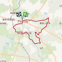
Ruta Senderismo de 14,1 km a descubrir en Centro, Indre y Loira, Pernay. Esta ruta ha sido propuesta por LEMENIO.
Descripción
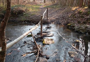
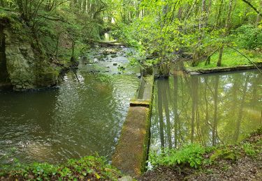
Départ : parking place de la mairie - petite route goudronnée au début (1 km) puis chemins dans les bois pour une bonne part.
Localización
País:
France
Región :
Centro
Departamento/provincia :
Indre y Loira
Municipio :
Pernay
Localidad:
Unknown
Salida:(Dec)
Salida:(UTM)
311416 ; 5257637 (31T) N.
Comentarios
Excursiones cerca
![Excursión Senderismo Ambillou - Ambillou - GRP Castelvalérie Château Champchevrier - 23.2km 165m 5h10 (30mn) - 2023 11 08 - Photo](https://media.geolcdn.com/t/375/260/ba45d8e3-f361-4ace-83cc-d433f0cfcf3d.jpg&format=jpg&maxdim=2)
![Senderismo Senderismo](https://static1.geolcdn.com/sitytour/trail-icons/101.png)
Ambillou - GRP Castelvalérie Château Champchevrier - 23.2km 165m 5h10 (30mn) ...
Senderismo
Fácil
Ambillou,
Centro,
Indre y Loira,
France
![](/images/other/stat-length.png)
23 km | 25 km-effort
5h 10min
![](https://static1.geolcdn.com/siteimages/upload/files/16400158638029165_repeat_loop_refresh_sync_direction_icon.png)
Sí
![Excursión Senderismo Ambillou - Ambillou - GRP Castelvalérie - 11.9km 90m 2h30 - 2021 06 16 - Photo](https://media.geolcdn.com/t/375/260/d87342d3-be15-4ef2-bc90-e71a0cf6d46c.jpg&format=jpg&maxdim=2)
![Senderismo Senderismo](https://static1.geolcdn.com/sitytour/trail-icons/101.png)
Ambillou - GRP Castelvalérie - 11.9km 90m 2h30 - 2021 06 16
Senderismo
Muy fácil
Ambillou,
Centro,
Indre y Loira,
France
![](/images/other/stat-length.png)
11,9 km | 13,1 km-effort
2h 30min
![](https://static1.geolcdn.com/siteimages/upload/files/16400158638029165_repeat_loop_refresh_sync_direction_icon.png)
Sí
![Excursión Senderismo Pernay - Pernay1 - Photo](https://media.geolcdn.com/t/375/260/ext.jpg?maxdim=2&url=https%3A%2F%2Fstatic1.geolcdn.com%2Fsiteimages%2Fupload%2Ffiles%2F1553511878bg_sport_marche.png)
![Senderismo Senderismo](https://static1.geolcdn.com/sitytour/trail-icons/101.png)
Pernay1
Senderismo
Fácil
(1)
Pernay,
Centro,
Indre y Loira,
France
![](/images/other/stat-length.png)
13,3 km | 15,4 km-effort
Desconocido
![](https://static1.geolcdn.com/siteimages/upload/files/16400158638029165_repeat_loop_refresh_sync_direction_icon.png)
Sí
![Senderismo Senderismo](https://static1.geolcdn.com/sitytour/trail-icons/101.png)
Pernay - 18.4km - 4h40 - 2016 05 01
Senderismo
Fácil
Pernay,
Centro,
Indre y Loira,
France
![](/images/other/stat-length.png)
18,4 km | 22 km-effort
4h 40min
![](https://static1.geolcdn.com/siteimages/upload/files/16400158638029165_repeat_loop_refresh_sync_direction_icon.png)
Sí
![Excursión Senderismo Pernay - Au Milieu Des Bois De Pernay - Photo](https://media.geolcdn.com/t/375/260/ext.jpg?maxdim=2&url=https%3A%2F%2Fservices.sitytrail.com%2FGeolivesWS%2FDownloadMedia.ashx%3FTrailID%3D117012%26Media%3Df134f822-3042-499a-b356-59d2ea59c8a4.JPG)
![Senderismo Senderismo](https://static1.geolcdn.com/sitytour/trail-icons/101.png)
Au Milieu Des Bois De Pernay
Senderismo
Fácil
Pernay,
Centro,
Indre y Loira,
France
![](/images/other/stat-length.png)
11,2 km | 13,3 km-effort
2h 15min
![](https://static1.geolcdn.com/siteimages/upload/files/16400158638029165_repeat_loop_refresh_sync_direction_icon.png)
Sí
![Excursión Senderismo Luynes - La Sacquemière - Photo](https://media.geolcdn.com/t/375/260/ext.jpg?maxdim=2&url=https%3A%2F%2Fstatic1.geolcdn.com%2Fsiteimages%2Fupload%2Ffiles%2F1553511878bg_sport_marche.png)
![Senderismo Senderismo](https://static1.geolcdn.com/sitytour/trail-icons/101.png)
La Sacquemière
Senderismo
Muy fácil
Luynes,
Centro,
Indre y Loira,
France
![](/images/other/stat-length.png)
6,1 km | 6,9 km-effort
1h 40min
![](https://static1.geolcdn.com/siteimages/upload/files/16400158638029165_repeat_loop_refresh_sync_direction_icon.png)
Sí
![Excursión Senderismo Pernay - 2021.11.18-6,60 km-Pernay - Photo](https://media.geolcdn.com/t/375/260/4b2e140a-c420-4d7b-bb78-1f9a04842bb4.jpg&format=jpg&maxdim=2)
![Senderismo Senderismo](https://static1.geolcdn.com/sitytour/trail-icons/101.png)
2021.11.18-6,60 km-Pernay
Senderismo
Medio
Pernay,
Centro,
Indre y Loira,
France
![](/images/other/stat-length.png)
6,6 km | 7,8 km-effort
1h 55min
![](https://static1.geolcdn.com/siteimages/upload/files/16400158638029165_repeat_loop_refresh_sync_direction_icon.png)
Sí
![Excursión Senderismo Pernay - 2019.05.02-8,9km-Pernay - Photo](https://media.geolcdn.com/t/375/260/be226718-c04e-47f4-905e-d24c7d8968b1.jpg&format=jpg&maxdim=2)
![Senderismo Senderismo](https://static1.geolcdn.com/sitytour/trail-icons/101.png)
2019.05.02-8,9km-Pernay
Senderismo
Fácil
Pernay,
Centro,
Indre y Loira,
France
![](/images/other/stat-length.png)
8,9 km | 10,2 km-effort
2h 7min
![](https://static1.geolcdn.com/siteimages/upload/files/16400158638029165_repeat_loop_refresh_sync_direction_icon.png)
Sí
![Excursión Senderismo Ambillou - Ambillou - Photo](https://media.geolcdn.com/t/375/260/ext.jpg?maxdim=2&url=https%3A%2F%2Fstatic1.geolcdn.com%2Fsiteimages%2Fupload%2Ffiles%2F1553511878bg_sport_marche.png)
![Senderismo Senderismo](https://static1.geolcdn.com/sitytour/trail-icons/101.png)
Ambillou
Senderismo
Medio
Ambillou,
Centro,
Indre y Loira,
France
![](/images/other/stat-length.png)
15,8 km | 17,4 km-effort
3h 52min
![](https://static1.geolcdn.com/siteimages/upload/files/16400158638029165_repeat_loop_refresh_sync_direction_icon.png)
Sí