![](/images/other/stat-length.png)
![Excursión Carrera La Ferté-Bernard - De St Julien aux champs - Photo](https://media.geolcdn.com/t/1900/400/ext.pjpeg?maxdim=2&url=https%3A%2F%2Fstatic1.geolcdn.com%2Fsiteimages%2Fupload%2Ffiles%2F1524743154running.jpg)
De St Julien aux champs
bobtail63
Usuario
![Longitud](/images/other/stat-length.png)
Longitud
8,7 km
![Altitud máxima](https://static1.geolcdn.com/siteimages/upload/files/1508320355ic_sort_altitude_max_24dp.png)
Altitud máxima
183 m
![Desnivel positivo](https://static1.geolcdn.com/siteimages/upload/files/1508320355ic_sort_den_pos_24dp.png)
Desnivel positivo
145 m
![Km-Effort](/images/other/stat-length.png)
Km-Effort
10,7 km
![Altitud mínima](https://static1.geolcdn.com/siteimages/upload/files/1508320355ic_sort_altitude_min_24dp.png)
Altitud mínima
83 m
![Desnivel negativo](https://static1.geolcdn.com/siteimages/upload/files/1508320355ic_sort_den_neg_24dp.png)
Desnivel negativo
145 m
![Boucle](https://static1.geolcdn.com/siteimages/upload/files/16400158638029165_repeat_loop_refresh_sync_direction_icon.png)
Boucle
Sí
Fecha de creación :
2014-12-10 00:00:00.0
Última modificación :
2014-12-10 00:00:00.0
![Carrera](https://static1.geolcdn.com/sitytour/trail-icons/103.png)
53m
Dificultad : Muy fácil
![Escanee este código QR para abrir la excursión en la aplicación SityTrail](https://capi.geolives.com/qq0zvz2zws4bq2lad0pu/sitytour/trails/114121/qr.png?size=200)
Aplicación GPS de excursión GRATIS
A propósito
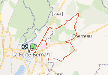
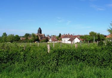
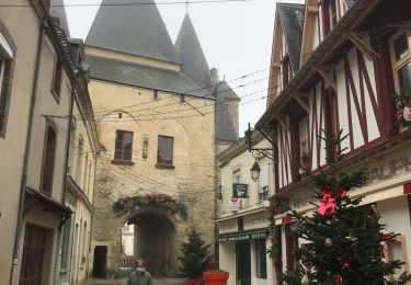
Ruta Carrera de 8,7 km a descubrir en Países del Loira, Sarthe, La Ferté-Bernard. Esta ruta ha sido propuesta por bobtail63.
Descripción
Depart du parking derrière saint Julien. Ce tracé permet de s'échauffer sur du bitume avant de rejoindre les chemins et quelques petites montées. Attention, gras en hiver.
Localización
País:
France
Región :
Países del Loira
Departamento/provincia :
Sarthe
Municipio :
La Ferté-Bernard
Localidad:
Unknown
Salida:(Dec)
Salida:(UTM)
325637 ; 5339702 (31U) N.
Comentarios
Excursiones cerca
![Excursión Senderismo Avezé - avezé Sarthe - Photo](https://media.geolcdn.com/t/375/260/ext.jpg?maxdim=2&url=https%3A%2F%2Fservices.sitytrail.com%2FGeolivesWS%2FDownloadMedia.ashx%3FTrailID%3D996959%26Media%3Dfix__20180701132821.jpg)
![Senderismo Senderismo](https://static1.geolcdn.com/sitytour/trail-icons/101.png)
avezé Sarthe
Senderismo
Fácil
Avezé,
Países del Loira,
Sarthe,
France
![](/images/other/stat-length.png)
13,4 km | 15,9 km-effort
4h 17min
![](https://static1.geolcdn.com/siteimages/upload/files/16400158638029165_repeat_loop_refresh_sync_direction_icon.png)
Sí
![Excursión Senderismo Cherré-Au - Cherreau - Sur le sentier des lièvres - Photo](https://media.geolcdn.com/t/375/260/ext.jpg?maxdim=2&url=https%3A%2F%2Fservices.sitytrail.com%2FGeolivesWS%2FDownloadMedia.ashx%3FTrailID%3D110127%26Media%3D5321_1.jpg)
![Senderismo Senderismo](https://static1.geolcdn.com/sitytour/trail-icons/101.png)
Cherreau - Sur le sentier des lièvres
Senderismo
Medio
Cherré-Au,
Países del Loira,
Sarthe,
France
![](/images/other/stat-length.png)
6,7 km | 8,4 km-effort
1h 30min
![](https://static1.geolcdn.com/siteimages/upload/files/16400158638029165_repeat_loop_refresh_sync_direction_icon.png)
Sí
![Excursión Senderismo Souvigné-sur-Même - Souvigné sur Même - Paysages de la Vallée de l'Huisne - Photo](https://media.geolcdn.com/t/375/260/ext.jpg?maxdim=2&url=https%3A%2F%2Fservices.sitytrail.com%2FGeolivesWS%2FDownloadMedia.ashx%3FTrailID%3D110083%26Media%3D5244_1.jpg)
![Senderismo Senderismo](https://static1.geolcdn.com/sitytour/trail-icons/101.png)
Souvigné sur Même - Paysages de la Vallée de l'Huisne
Senderismo
Medio
Souvigné-sur-Même,
Países del Loira,
Sarthe,
France
![](/images/other/stat-length.png)
6 km | 7,8 km-effort
1h 30min
![](https://static1.geolcdn.com/siteimages/upload/files/16400158638029165_repeat_loop_refresh_sync_direction_icon.png)
Sí
![Excursión Senderismo Avezé - Avezé - Au coeur du bocage percheron - Photo](https://media.geolcdn.com/t/375/260/ext.jpg?maxdim=2&url=https%3A%2F%2Fservices.sitytrail.com%2FGeolivesWS%2FDownloadMedia.ashx%3FTrailID%3D110015%26Media%3D5119_1.jpg)
![Senderismo Senderismo](https://static1.geolcdn.com/sitytour/trail-icons/101.png)
Avezé - Au coeur du bocage percheron
Senderismo
Medio
Avezé,
Países del Loira,
Sarthe,
France
![](/images/other/stat-length.png)
14,6 km | 17,7 km-effort
3h 30min
![](https://static1.geolcdn.com/siteimages/upload/files/16400158638029165_repeat_loop_refresh_sync_direction_icon.png)
Sí
![Excursión Carrera La Ferté-Bernard - La Ferté Bernard trace - Photo](https://media.geolcdn.com/t/375/260/ext.jpg?maxdim=2&url=https%3A%2F%2Fmedia.geolcdn.com%2Ff%2Fd16d4168-41ec-4f47-b99c-5168db04f47b.jpg)
![Carrera Carrera](https://static1.geolcdn.com/sitytour/trail-icons/103.png)
La Ferté Bernard trace
Carrera
La Ferté-Bernard,
Países del Loira,
Sarthe,
France
![](/images/other/stat-length.png)
9,4 km | 10,1 km-effort
1h 5min
![](https://static1.geolcdn.com/siteimages/upload/files/16400158638029165_repeat_loop_refresh_sync_direction_icon.png)
Sí
![Excursión Bici de montaña La Ferté-Bernard - La Ferté Bernard - Sablé sur Sarthe 3ieme jour - Photo](https://media.geolcdn.com/t/375/260/ext.jpg?maxdim=2&url=https%3A%2F%2Fmedia.geolcdn.com%2Ff%2Ff1adcf78-1864-4c5a-9623-0c71ff50a6a3.jpg)
![Bici de montaña Bici de montaña](https://static1.geolcdn.com/sitytour/trail-icons/202.png)
La Ferté Bernard - Sablé sur Sarthe 3ieme jour
Bici de montaña
Medio
La Ferté-Bernard,
Países del Loira,
Sarthe,
France
![](/images/other/stat-length.png)
103 km | 114 km-effort
6h 1min
![](https://static1.geolcdn.com/siteimages/upload/files/16400158638029165_repeat_loop_refresh_sync_direction_icon.png)
No
![Excursión Bici de montaña La Ferté-Bernard - Essai BRT J3 103KM D+800 - MATIN 58KM D+ / APRES MIDI 45KM D+ - Photo](https://media.geolcdn.com/t/375/260/ext.jpg?maxdim=2&url=https%3A%2F%2Fstatic1.geolcdn.com%2Fsiteimages%2Fupload%2Ffiles%2F1524743154velo.jpg)
![Bici de montaña Bici de montaña](https://static1.geolcdn.com/sitytour/trail-icons/202.png)
Essai BRT J3 103KM D+800 - MATIN 58KM D+ / APRES MIDI 45KM D+
Bici de montaña
Medio
La Ferté-Bernard,
Países del Loira,
Sarthe,
France
![](/images/other/stat-length.png)
103 km | 114 km-effort
1h 31min
![](https://static1.geolcdn.com/siteimages/upload/files/16400158638029165_repeat_loop_refresh_sync_direction_icon.png)
No
![Excursión Otra actividad La Ferté-Bernard - R,e,T J3 - Photo](https://media.geolcdn.com/t/375/260/ext.jpg?maxdim=2&url=https%3A%2F%2Fstatic1.geolcdn.com%2Fsiteimages%2Fupload%2Ffiles%2F1545311037marcheuse_200dpi.jpg)
![Otra actividad Otra actividad](https://static1.geolcdn.com/sitytour/trail-icons/900.png)
R,e,T J3
Otra actividad
Muy fácil
La Ferté-Bernard,
Países del Loira,
Sarthe,
France
![](/images/other/stat-length.png)
114 km | 128 km-effort
10h 0min
![](https://static1.geolcdn.com/siteimages/upload/files/16400158638029165_repeat_loop_refresh_sync_direction_icon.png)
No
![Excursión Senderismo Souvigné-sur-Même - Souvigné-sur-Même 10,1km - Photo](https://media.geolcdn.com/t/375/260/ext.jpg?maxdim=2&url=https%3A%2F%2Fstatic1.geolcdn.com%2Fsiteimages%2Fupload%2Ffiles%2F1553511878bg_sport_marche.png)
![Senderismo Senderismo](https://static1.geolcdn.com/sitytour/trail-icons/101.png)
Souvigné-sur-Même 10,1km
Senderismo
Fácil
(1)
Souvigné-sur-Même,
Países del Loira,
Sarthe,
France
![](/images/other/stat-length.png)
10,1 km | 12,2 km-effort
2h 40min
![](https://static1.geolcdn.com/siteimages/upload/files/16400158638029165_repeat_loop_refresh_sync_direction_icon.png)
Sí