![](/images/other/stat-length.png)
![Excursión Senderismo Jarsy - Mont Pécloz par les crêtes - Photo](https://media.geolcdn.com/t/1900/400/ext.pjpeg?maxdim=2&url=https%3A%2F%2Fservices.sitytrail.com%2FGeolivesWS%2FDownloadMedia.ashx%3FTrailID%3D1130859%26Media%3Dfix__20181018131122.jpg)
Mont Pécloz par les crêtes
Michel_Martin
Usuario
![Longitud](/images/other/stat-length.png)
Longitud
14,6 km
![Altitud máxima](https://static1.geolcdn.com/siteimages/upload/files/1508320355ic_sort_altitude_max_24dp.png)
Altitud máxima
2174 m
![Desnivel positivo](https://static1.geolcdn.com/siteimages/upload/files/1508320355ic_sort_den_pos_24dp.png)
Desnivel positivo
1433 m
![Km-Effort](/images/other/stat-length.png)
Km-Effort
34 km
![Altitud mínima](https://static1.geolcdn.com/siteimages/upload/files/1508320355ic_sort_altitude_min_24dp.png)
Altitud mínima
871 m
![Desnivel negativo](https://static1.geolcdn.com/siteimages/upload/files/1508320355ic_sort_den_neg_24dp.png)
Desnivel negativo
1572 m
![Boucle](https://static1.geolcdn.com/siteimages/upload/files/16400158638029165_repeat_loop_refresh_sync_direction_icon.png)
Boucle
No
Fecha de creación :
2019-04-16 15:16:55.71
Última modificación :
2019-04-16 15:16:55.71
![Senderismo](https://static1.geolcdn.com/sitytour/trail-icons/101.png)
6h35
Dificultad : Difícil
![Escanee este código QR para abrir la excursión en la aplicación SityTrail](https://capi.geolives.com/qq0zvz2zws4bq2lad0pu/sitytour/trails/1130859/qr.png?size=200)
Aplicación GPS de excursión GRATIS
A propósito
Ruta Senderismo de 14,6 km a descubrir en Auvergne-Rhône-Alpes, Saboya, Jarsy. Esta ruta ha sido propuesta por Michel_Martin.
Descripción
Attention ne manquez la bifurcation à droite pour les Fougères au dessus du Nant Fourchu
Localización
País:
France
Región :
Auvergne-Rhône-Alpes
Departamento/provincia :
Saboya
Municipio :
Jarsy
Localidad:
Unknown
Salida:(Dec)
Salida:(UTM)
284689 ; 5058383 (32T) N.
Comentarios
Excursiones cerca
![Excursión Senderismo Jarsy - BAUGES: PRECHEREL - CROIX D'ALLANT - PLAN DE LA LIMACE - en direction du Mont de la Coche - Photo](https://media.geolcdn.com/t/375/260/a1c1a220-f26a-4fbe-a6ad-eda1f1982f07.jpg&format=jpg&maxdim=2)
![Senderismo Senderismo](https://static1.geolcdn.com/sitytour/trail-icons/101.png)
BAUGES: PRECHEREL - CROIX D'ALLANT - PLAN DE LA LIMACE - en direction du Mont...
Senderismo
Difícil
(1)
Jarsy,
Auvergne-Rhône-Alpes,
Saboya,
France
![](/images/other/stat-length.png)
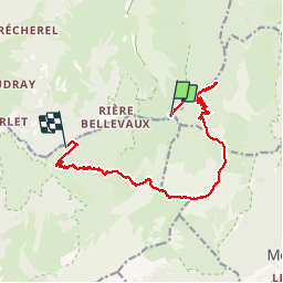
13,1 km | 24 km-effort
4h 45min
![](https://static1.geolcdn.com/siteimages/upload/files/16400158638029165_repeat_loop_refresh_sync_direction_icon.png)
Sí
![Excursión Senderismo Plancherine - chalet de Drison à nant fourchu - Photo](https://media.geolcdn.com/t/375/260/6cfabcdf-e1f7-4c6d-be83-f3ce4d597931.jpg&format=jpg&maxdim=2)
![Senderismo Senderismo](https://static1.geolcdn.com/sitytour/trail-icons/101.png)
chalet de Drison à nant fourchu
Senderismo
Medio
Plancherine,
Auvergne-Rhône-Alpes,
Saboya,
France
![](/images/other/stat-length.png)
9,6 km | 18,3 km-effort
3h 23min
![](https://static1.geolcdn.com/siteimages/upload/files/16400158638029165_repeat_loop_refresh_sync_direction_icon.png)
No
![Excursión Senderismo Jarsy - parc à moutons - Photo](https://media.geolcdn.com/t/375/260/11b94c96-e376-4153-b4eb-464e23c1ffc4.jpg&format=jpg&maxdim=2)
![Senderismo Senderismo](https://static1.geolcdn.com/sitytour/trail-icons/101.png)
parc à moutons
Senderismo
Medio
Jarsy,
Auvergne-Rhône-Alpes,
Saboya,
France
![](/images/other/stat-length.png)
11,3 km | 25 km-effort
6h 0min
![](https://static1.geolcdn.com/siteimages/upload/files/16400158638029165_repeat_loop_refresh_sync_direction_icon.png)
No
![Excursión Senderismo École - Dent et col d'Arclusaz par le col de la cochette - Photo](https://media.geolcdn.com/t/375/260/feaa7030-038c-4a29-b681-d1c2b1a0e6a1.jpg&format=jpg&maxdim=2)
![Senderismo Senderismo](https://static1.geolcdn.com/sitytour/trail-icons/101.png)
Dent et col d'Arclusaz par le col de la cochette
Senderismo
Difícil
École,
Auvergne-Rhône-Alpes,
Saboya,
France
![](/images/other/stat-length.png)
15,9 km | 33 km-effort
6h 18min
![](https://static1.geolcdn.com/siteimages/upload/files/16400158638029165_repeat_loop_refresh_sync_direction_icon.png)
Sí
![Excursión Paseo ecuestre Sainte-Hélène-sur-Isère - boucle NDMillières Aiton - Photo](https://media.geolcdn.com/t/375/260/ext.jpg?maxdim=2&url=https%3A%2F%2Fstatic1.geolcdn.com%2Fsiteimages%2Fupload%2Ffiles%2F1524743154cheval.jpg)
![Paseo ecuestre Paseo ecuestre](https://static1.geolcdn.com/sitytour/trail-icons/301.png)
boucle NDMillières Aiton
Paseo ecuestre
Muy fácil
(1)
Sainte-Hélène-sur-Isère,
Auvergne-Rhône-Alpes,
Saboya,
France
![](/images/other/stat-length.png)
14,1 km | 16,3 km-effort
2h 30min
![](https://static1.geolcdn.com/siteimages/upload/files/16400158638029165_repeat_loop_refresh_sync_direction_icon.png)
Sí
![Excursión Senderismo Jarsy - col orgeval - Photo](https://media.geolcdn.com/t/375/260/ext.jpg?maxdim=2&url=https%3A%2F%2Fstatic1.geolcdn.com%2Fsiteimages%2Fupload%2Ffiles%2F1553511878bg_sport_marche.png)
![Senderismo Senderismo](https://static1.geolcdn.com/sitytour/trail-icons/101.png)
col orgeval
Senderismo
Fácil
(1)
Jarsy,
Auvergne-Rhône-Alpes,
Saboya,
France
![](/images/other/stat-length.png)
11,9 km | 22 km-effort
Desconocido
![](https://static1.geolcdn.com/siteimages/upload/files/16400158638029165_repeat_loop_refresh_sync_direction_icon.png)
Sí
![Excursión Senderismo Jarsy - nôtre dame de Bellevaux - Photo](https://media.geolcdn.com/t/375/260/1be31ea5-d3d1-459b-88d3-6aa2e29612aa.jpg&format=jpg&maxdim=2)
![Senderismo Senderismo](https://static1.geolcdn.com/sitytour/trail-icons/101.png)
nôtre dame de Bellevaux
Senderismo
Muy fácil
Jarsy,
Auvergne-Rhône-Alpes,
Saboya,
France
![](/images/other/stat-length.png)
5,2 km | 7,9 km-effort
1h 28min
![](https://static1.geolcdn.com/siteimages/upload/files/16400158638029165_repeat_loop_refresh_sync_direction_icon.png)
Sí
![Senderismo Senderismo](https://static1.geolcdn.com/sitytour/trail-icons/101.png)
Croix d'Allant et Plan de la Limace
Senderismo
Muy difícil
Jarsy,
Auvergne-Rhône-Alpes,
Saboya,
France
![](/images/other/stat-length.png)
14,6 km | 26 km-effort
6h 29min
![](https://static1.geolcdn.com/siteimages/upload/files/16400158638029165_repeat_loop_refresh_sync_direction_icon.png)
Sí
![Excursión Esquí de fondo École - pointe des Arlicots - Photo](https://media.geolcdn.com/t/375/260/7ea3a78f-9737-4674-ba73-476172d62101.jpg&format=jpg&maxdim=2)
![Esquí de fondo Esquí de fondo](https://static1.geolcdn.com/sitytour/trail-icons/503.png)
pointe des Arlicots
Esquí de fondo
Medio
École,
Auvergne-Rhône-Alpes,
Saboya,
France
![](/images/other/stat-length.png)
9,2 km | 23 km-effort
4h 56min
![](https://static1.geolcdn.com/siteimages/upload/files/16400158638029165_repeat_loop_refresh_sync_direction_icon.png)
No