![](/images/other/stat-length.png)
![Excursión Bici de montaña Romans - Zevtt - Romans VTT 70km - Photo](https://media.geolcdn.com/t/1900/400/ext.pjpeg?maxdim=2&url=https%3A%2F%2Fstatic1.geolcdn.com%2Fsiteimages%2Fupload%2Ffiles%2F1524743154velo.jpg)
Zevtt - Romans VTT 70km
kipoura
Usuario
![Longitud](/images/other/stat-length.png)
Longitud
69 km
![Altitud máxima](https://static1.geolcdn.com/siteimages/upload/files/1508320355ic_sort_altitude_max_24dp.png)
Altitud máxima
186 m
![Desnivel positivo](https://static1.geolcdn.com/siteimages/upload/files/1508320355ic_sort_den_pos_24dp.png)
Desnivel positivo
1139 m
![Km-Effort](/images/other/stat-length.png)
Km-Effort
84 km
![Altitud mínima](https://static1.geolcdn.com/siteimages/upload/files/1508320355ic_sort_altitude_min_24dp.png)
Altitud mínima
54 m
![Desnivel negativo](https://static1.geolcdn.com/siteimages/upload/files/1508320355ic_sort_den_neg_24dp.png)
Desnivel negativo
1139 m
![Boucle](https://static1.geolcdn.com/siteimages/upload/files/16400158638029165_repeat_loop_refresh_sync_direction_icon.png)
Boucle
Sí
Fecha de creación :
2019-05-03 17:11:17.985
Última modificación :
2019-05-03 17:11:18.171
![Bici de montaña](https://static1.geolcdn.com/sitytour/trail-icons/202.png)
4h00
Dificultad : Difícil
![Escanee este código QR para abrir la excursión en la aplicación SityTrail](https://capi.geolives.com/qq0zvz2zws4bq2lad0pu/sitytour/trails/113034/qr.png?size=200)
Aplicación GPS de excursión GRATIS
A propósito
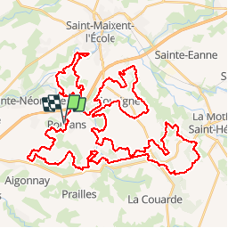
Ruta Bici de montaña de 69 km a descubrir en Nueva Aquitania, Deux-Sèvres, Romans. Esta ruta ha sido propuesta por kipoura.
Descripción
Une boucle VTT de 70 kilomètres, attention bonne condition physique obligatoire ..... http://zevtt.free.fr
Localización
País:
France
Región :
Nueva Aquitania
Departamento/provincia :
Deux-Sèvres
Municipio :
Romans
Localidad:
Unknown
Salida:(Dec)
Salida:(UTM)
713152 ; 5137835 (30T) N.
Comentarios
Excursiones cerca
![Excursión Senderismo Fressines - Fressines-8,5km - Photo](https://media.geolcdn.com/t/375/260/ext.jpg?maxdim=2&url=https%3A%2F%2Fservices.sitytrail.com%2FGeolivesWS%2FDownloadMedia.ashx%3FTrailID%3D1043610%26Media%3D0965c3c4-63c0-4683-9b04-1ba1cf7b8e11.jpg)
![Senderismo Senderismo](https://static1.geolcdn.com/sitytour/trail-icons/101.png)
Fressines-8,5km
Senderismo
Medio
Fressines,
Nueva Aquitania,
Deux-Sèvres,
France
![](/images/other/stat-length.png)
8,5 km | 10,2 km-effort
2h 12min
![](https://static1.geolcdn.com/siteimages/upload/files/16400158638029165_repeat_loop_refresh_sync_direction_icon.png)
Sí
![Excursión Senderismo Fressines - Fressines-8,5km - Photo](https://media.geolcdn.com/t/375/260/ext.jpg?maxdim=2&url=https%3A%2F%2Fservices.sitytrail.com%2FGeolivesWS%2FDownloadMedia.ashx%3FTrailID%3D224755%26Media%3Dfix__20131001161142.jpg)
![Senderismo Senderismo](https://static1.geolcdn.com/sitytour/trail-icons/101.png)
Fressines-8,5km
Senderismo
Medio
Fressines,
Nueva Aquitania,
Deux-Sèvres,
France
![](/images/other/stat-length.png)
8,5 km | 10,2 km-effort
2h 12min
![](https://static1.geolcdn.com/siteimages/upload/files/16400158638029165_repeat_loop_refresh_sync_direction_icon.png)
Sí
![Excursión Senderismo Fressines - Fressines-11,7km - Photo](https://media.geolcdn.com/t/375/260/ext.jpg?maxdim=2&url=https%3A%2F%2Fservices.sitytrail.com%2FGeolivesWS%2FDownloadMedia.ashx%3FTrailID%3D132266%26Media%3D20120605143055.jpeg)
![Senderismo Senderismo](https://static1.geolcdn.com/sitytour/trail-icons/101.png)
Fressines-11,7km
Senderismo
Fácil
Fressines,
Nueva Aquitania,
Deux-Sèvres,
France
![](/images/other/stat-length.png)
11,7 km | 13,7 km-effort
3h 0min
![](https://static1.geolcdn.com/siteimages/upload/files/16400158638029165_repeat_loop_refresh_sync_direction_icon.png)
Sí
![Excursión Senderismo Fressines - 2021-09-29 Vers Fressines - Photo](https://media.geolcdn.com/t/375/260/28378c98-0e8f-4c16-b712-2d642594c8be.jpg&format=jpg&maxdim=2)
![Senderismo Senderismo](https://static1.geolcdn.com/sitytour/trail-icons/101.png)
2021-09-29 Vers Fressines
Senderismo
Medio
Fressines,
Nueva Aquitania,
Deux-Sèvres,
France
![](/images/other/stat-length.png)
8,4 km | 10,3 km-effort
2h 16min
![](https://static1.geolcdn.com/siteimages/upload/files/16400158638029165_repeat_loop_refresh_sync_direction_icon.png)
Sí
![Excursión Senderismo Aigondigné - 2021-07-26 Autour d'Aigonnay - Photo](https://media.geolcdn.com/t/375/260/99508bdd-92a4-49de-b540-92127da4177f.jpg&format=jpg&maxdim=2)
![Senderismo Senderismo](https://static1.geolcdn.com/sitytour/trail-icons/101.png)
2021-07-26 Autour d'Aigonnay
Senderismo
Medio
Aigondigné,
Nueva Aquitania,
Deux-Sèvres,
France
![](/images/other/stat-length.png)
19,2 km | 22 km-effort
2h 0min
![](https://static1.geolcdn.com/siteimages/upload/files/16400158638029165_repeat_loop_refresh_sync_direction_icon.png)
No
![Excursión Senderismo Aigondigné - 2019-09-09 Vers Aigonnay - Photo](https://media.geolcdn.com/t/375/260/75f33146-3b96-48ab-adc9-e41bf617b277.jpg&format=jpg&maxdim=2)
![Senderismo Senderismo](https://static1.geolcdn.com/sitytour/trail-icons/101.png)
2019-09-09 Vers Aigonnay
Senderismo
Medio
(1)
Aigondigné,
Nueva Aquitania,
Deux-Sèvres,
France
![](/images/other/stat-length.png)
8,7 km | 10,3 km-effort
2h 15min
![](https://static1.geolcdn.com/siteimages/upload/files/16400158638029165_repeat_loop_refresh_sync_direction_icon.png)
Sí
![Excursión Senderismo Fressines - Fressines-8,5km - Photo](https://media.geolcdn.com/t/375/260/cf59bf8b-5ee0-4871-899c-76be2f40d87d.jpg&format=jpg&maxdim=2)
![Senderismo Senderismo](https://static1.geolcdn.com/sitytour/trail-icons/101.png)
Fressines-8,5km
Senderismo
Medio
Fressines,
Nueva Aquitania,
Deux-Sèvres,
France
![](/images/other/stat-length.png)
8 km | 9,6 km-effort
2h 12min
![](https://static1.geolcdn.com/siteimages/upload/files/16400158638029165_repeat_loop_refresh_sync_direction_icon.png)
Sí
![Excursión Senderismo Aigondigné - AIGONNAY. 2017 - Photo](https://media.geolcdn.com/t/375/260/ext.jpg?maxdim=2&url=https%3A%2F%2Fservices.sitytrail.com%2FGeolivesWS%2FDownloadMedia.ashx%3FTrailID%3D831911%26Media%3Dfix__20170919160802.jpg)
![Senderismo Senderismo](https://static1.geolcdn.com/sitytour/trail-icons/101.png)
AIGONNAY. 2017
Senderismo
Medio
(1)
Aigondigné,
Nueva Aquitania,
Deux-Sèvres,
France
![](/images/other/stat-length.png)
8,8 km | 10,5 km-effort
2h 6min
![](https://static1.geolcdn.com/siteimages/upload/files/16400158638029165_repeat_loop_refresh_sync_direction_icon.png)
Sí
![Excursión Senderismo Sainte-Néomaye - 13-09-11 Sainte-Néomaye - Photo](https://media.geolcdn.com/t/375/260/ext.jpg?maxdim=2&url=https%3A%2F%2Fservices.sitytrail.com%2FGeolivesWS%2FDownloadMedia.ashx%3FTrailID%3D85215%26Media%3D20110913162224.jpeg)
![Senderismo Senderismo](https://static1.geolcdn.com/sitytour/trail-icons/101.png)
13-09-11 Sainte-Néomaye
Senderismo
Fácil
(1)
Sainte-Néomaye,
Nueva Aquitania,
Deux-Sèvres,
France
![](/images/other/stat-length.png)
7,7 km | 9,5 km-effort
Desconocido
![](https://static1.geolcdn.com/siteimages/upload/files/16400158638029165_repeat_loop_refresh_sync_direction_icon.png)
Sí