![](/images/other/stat-length.png)
![Excursión Senderismo Merville-Franceville-Plage - Sentier nature du Gros Banc - Photo](https://media.geolcdn.com/t/1900/400/ext.pjpeg?maxdim=2&url=https%3A%2F%2Fstatic1.geolcdn.com%2Fsiteimages%2Fupload%2Ffiles%2F1553511878bg_sport_marche.png)
Sentier nature du Gros Banc
neoroll44
Usuario
![Longitud](/images/other/stat-length.png)
![Altitud máxima](https://static1.geolcdn.com/siteimages/upload/files/1508320355ic_sort_altitude_max_24dp.png)
![Desnivel positivo](https://static1.geolcdn.com/siteimages/upload/files/1508320355ic_sort_den_pos_24dp.png)
![Km-Effort](/images/other/stat-length.png)
![Altitud mínima](https://static1.geolcdn.com/siteimages/upload/files/1508320355ic_sort_altitude_min_24dp.png)
![Desnivel negativo](https://static1.geolcdn.com/siteimages/upload/files/1508320355ic_sort_den_neg_24dp.png)
![Boucle](https://static1.geolcdn.com/siteimages/upload/files/16400158638029165_repeat_loop_refresh_sync_direction_icon.png)
![Senderismo](https://static1.geolcdn.com/sitytour/trail-icons/101.png)
45m
Dificultad : Fácil
![Escanee este código QR para abrir la excursión en la aplicación SityTrail](https://capi.geolives.com/qq0zvz2zws4bq2lad0pu/sitytour/trails/1128676/qr.png?size=200)
Aplicación GPS de excursión GRATIS
A propósito
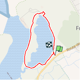
Ruta Senderismo de 3 km a descubrir en Normandía, Calvados, Merville-Franceville-Plage. Esta ruta ha sido propuesta por neoroll44.
Descripción
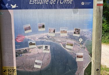
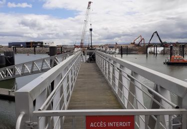
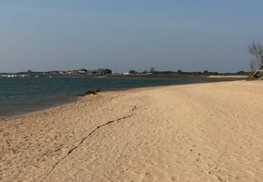
Lors de la marée haute, le Gros banc accueille de nombreux oiseaux, que vous pouvez observer depuis l’observatoire Beaulieu de Merville-Franceville. Il est interdit de pénétrer dans le Gros Banc et de franchir les clôtures. Cette boucle est à faire à marée de coefficient inférieur à 80.
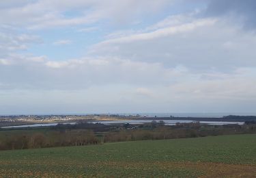
1. Du parking près de la station d'épuration, faire 80 m pour arriver à l'observatoire Beaulieu puis partir sur votre gauche, en longeant le Gros banc sur 370 m.
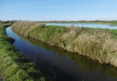
2. A l'intersection, prendre sur votre droite pour contourner le Gros banc et faire 360 m jusqu'à la palissade d'observation.
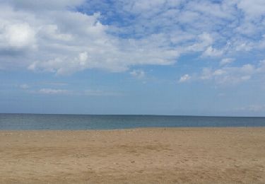
3. A partir de cette palissade, à marée haute de coefficient supérieur à 80 le sentier est recouvert par la mer. Dans les autres cas, vous pouvez poursuivre la boucle en marchant sur la plage du Gros Banc sur 760 m.
4. Avant d'arriver à la digue de l'école de voile, monter le talus et prendre le petit sentier et faire 460 m avant d'arriver à l'extrémité Nord du Gros banc. Sur le trajet, 2 palissades vous permettront de jeter un oeil à l'intérieur du Gros Banc.
5. En traversant la route, vous pourrez aller voir la fortification type Vauban, la Redoute et également monter sur un blockhaus.
Localización
Comentarios
Excursiones cerca
![Excursión Senderismo Merville-Franceville-Plage - Balade découverte autour de Merville - Photo](https://media.geolcdn.com/t/375/260/d0b7039c-e1ac-4daf-b212-abb8614d96e7.jpg&format=jpg&maxdim=2)
![Senderismo Senderismo](https://static1.geolcdn.com/sitytour/trail-icons/101.png)
Senderismo
![](/images/other/stat-length.png)
![](https://static1.geolcdn.com/siteimages/upload/files/16400158638029165_repeat_loop_refresh_sync_direction_icon.png)
![Excursión Senderismo Merville-Franceville-Plage - HONFLEUR 06 - OUISTREHAM : Les Dunes - La Redoute (Normandie) - Photo](https://media.geolcdn.com/t/375/260/3672140d-5a9b-46d0-a351-c2d13b398b9e.jpg&format=jpg&maxdim=2)
![Senderismo Senderismo](https://static1.geolcdn.com/sitytour/trail-icons/101.png)
Senderismo
![](/images/other/stat-length.png)
![](https://static1.geolcdn.com/siteimages/upload/files/16400158638029165_repeat_loop_refresh_sync_direction_icon.png)
![Excursión Bici de carretera Merville-Franceville-Plage - Merville Caen - Photo](https://media.geolcdn.com/t/375/260/c81a8d40-bd2c-4971-b1f0-ce64fccb30d4.jpg&format=jpg&maxdim=2)
![Bici de carretera Bici de carretera](https://static1.geolcdn.com/sitytour/trail-icons/201.png)
Bici de carretera
![](/images/other/stat-length.png)
![](https://static1.geolcdn.com/siteimages/upload/files/16400158638029165_repeat_loop_refresh_sync_direction_icon.png)
![Excursión Senderismo Ouistreham - Oustreham - Photo](https://media.geolcdn.com/t/375/260/45ffe55d-02b7-4967-8287-a80bed6a58aa.jpg&format=jpg&maxdim=2)
![Senderismo Senderismo](https://static1.geolcdn.com/sitytour/trail-icons/101.png)
Senderismo
![](/images/other/stat-length.png)
![](https://static1.geolcdn.com/siteimages/upload/files/16400158638029165_repeat_loop_refresh_sync_direction_icon.png)
![Excursión Senderismo Bénouville - Benouville - Photo](https://media.geolcdn.com/t/375/260/d049fb97-5aff-4d4c-9c12-dd0a62c22fc4.jpg&format=jpg&maxdim=2)
![Senderismo Senderismo](https://static1.geolcdn.com/sitytour/trail-icons/101.png)
Senderismo
![](/images/other/stat-length.png)
![](https://static1.geolcdn.com/siteimages/upload/files/16400158638029165_repeat_loop_refresh_sync_direction_icon.png)
![Senderismo Senderismo](https://static1.geolcdn.com/sitytour/trail-icons/101.png)
Senderismo
![](/images/other/stat-length.png)
![](https://static1.geolcdn.com/siteimages/upload/files/16400158638029165_repeat_loop_refresh_sync_direction_icon.png)
![Excursión Senderismo Sallenelles - Sellenelles à Franceville Merville - Photo](https://media.geolcdn.com/t/375/260/ext.jpg?maxdim=2&url=https%3A%2F%2Fservices.sitytrail.com%2FGeolivesWS%2FDownloadMedia.ashx%3FTrailID%3D756905%26Media%3Dfix__20170513120035.jpg)
![Senderismo Senderismo](https://static1.geolcdn.com/sitytour/trail-icons/101.png)
Senderismo
![](/images/other/stat-length.png)
![](https://static1.geolcdn.com/siteimages/upload/files/16400158638029165_repeat_loop_refresh_sync_direction_icon.png)
![Excursión Carrera Merville-Franceville-Plage - circuit autour de merville - Photo](https://media.geolcdn.com/t/375/260/ext.jpg?maxdim=2&url=https%3A%2F%2Fservices.sitytrail.com%2FGeolivesWS%2FDownloadMedia.ashx%3FTrailID%3D736587%26Media%3D20170420180024.jpg)
![Carrera Carrera](https://static1.geolcdn.com/sitytour/trail-icons/103.png)
Carrera
![](/images/other/stat-length.png)
![](https://static1.geolcdn.com/siteimages/upload/files/16400158638029165_repeat_loop_refresh_sync_direction_icon.png)
![Excursión Senderismo Petiville - 2013-07-17 Rando Les cigognes des marais - Photo](https://media.geolcdn.com/t/375/260/ext.jpg?maxdim=2&url=https%3A%2F%2Fstatic1.geolcdn.com%2Fsiteimages%2Fupload%2Ffiles%2F1553511878bg_sport_marche.png)
![Senderismo Senderismo](https://static1.geolcdn.com/sitytour/trail-icons/101.png)
Senderismo
![](/images/other/stat-length.png)
![](https://static1.geolcdn.com/siteimages/upload/files/16400158638029165_repeat_loop_refresh_sync_direction_icon.png)