![](/images/other/stat-length.png)
![Excursión Senderismo Turriers - La Carraire du bois de Gierre - Turriers - Photo](https://media.geolcdn.com/t/1900/400/ext.pjpeg?maxdim=2&url=https%3A%2F%2Fservices.sitytrail.com%2FGeolivesWS%2FDownloadMedia.ashx%3FTrailID%3D112783%26Media%3D12382_5.jpg)
La Carraire du bois de Gierre - Turriers
tracegps
Usuario
![Longitud](/images/other/stat-length.png)
![Altitud máxima](https://static1.geolcdn.com/siteimages/upload/files/1508320355ic_sort_altitude_max_24dp.png)
![Desnivel positivo](https://static1.geolcdn.com/siteimages/upload/files/1508320355ic_sort_den_pos_24dp.png)
![Km-Effort](/images/other/stat-length.png)
![Altitud mínima](https://static1.geolcdn.com/siteimages/upload/files/1508320355ic_sort_altitude_min_24dp.png)
![Desnivel negativo](https://static1.geolcdn.com/siteimages/upload/files/1508320355ic_sort_den_neg_24dp.png)
![Boucle](https://static1.geolcdn.com/siteimages/upload/files/16400158638029165_repeat_loop_refresh_sync_direction_icon.png)
![Senderismo](https://static1.geolcdn.com/sitytour/trail-icons/101.png)
3h00
Dificultad : Difícil
![Escanee este código QR para abrir la excursión en la aplicación SityTrail](https://capi.geolives.com/qq0zvz2zws4bq2lad0pu/sitytour/trails/112783/qr.png?size=200)
Aplicación GPS de excursión GRATIS
A propósito
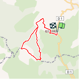
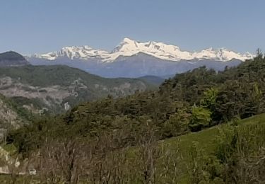
Ruta Senderismo de 7,9 km a descubrir en Provenza-Alpes-Costa Azul, Alpes de Alta Provenza, Turriers. Esta ruta ha sido propuesta por tracegps.
Descripción
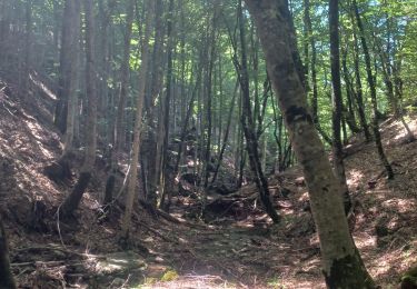
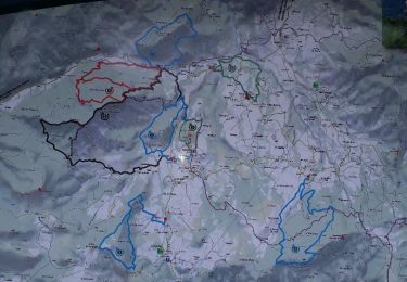
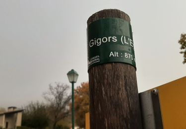
Se garer de préférence avant le hameau de Gierre. Traverser celui-ci et poursuivre son chemin par la piste du grand bois. Au croisement du bois de Gierre,rester sur la piste de gauche jusqu’au bout de celle-ci. Descendre ensuite à travers les hêtres pour rejoindre une autre piste. Attention, vous entrez sur des propriétés privées, veuillez ne pas vous éloignez du sentier balisé. Prendre ensuite la piste sur votre droite jusqu’à un petit col que vous atteignez rapidement. De là, s’engager à droite par piste, sentier puis à nouveau piste jusqu’aux pâturages de la crête de Picouse. De suite après le dernier bosquet de pins, bifurquer à droite sur un sentier au départ peu visible, pour descendre à travers la hêtraie vers votre lieu de départ. Retrouvez le circuit sur le site des Hautes Terres de Provence.
Localización
Comentarios
Excursiones cerca
![Excursión Senderismo Faucon-du-Caire - FAUCON DU CAIRE RAVIN DE L ECHELLE . CRETES DES ROUYERES - Photo](https://media.geolcdn.com/t/375/260/9f83695f-f8d0-4892-a12b-1f657877f2be.jpg&format=jpg&maxdim=2)
![Senderismo Senderismo](https://static1.geolcdn.com/sitytour/trail-icons/101.png)
Senderismo
![](/images/other/stat-length.png)
![](https://static1.geolcdn.com/siteimages/upload/files/16400158638029165_repeat_loop_refresh_sync_direction_icon.png)
![Excursión Senderismo Gigors - GIGORS Cretes des Barses par variante n - Photo](https://media.geolcdn.com/t/375/260/dbf914d6-b25f-4023-818e-fa0613cb7f91.jpg&format=jpg&maxdim=2)
![Senderismo Senderismo](https://static1.geolcdn.com/sitytour/trail-icons/101.png)
Senderismo
![](/images/other/stat-length.png)
![](https://static1.geolcdn.com/siteimages/upload/files/16400158638029165_repeat_loop_refresh_sync_direction_icon.png)
![Excursión Senderismo Turriers - Turriers - Très Pébès - Photo](https://media.geolcdn.com/t/375/260/ext.jpg?maxdim=2&url=https%3A%2F%2Fservices.sitytrail.com%2FGeolivesWS%2FDownloadMedia.ashx%3FTrailID%3D934747%26Media%3D0ff6cfaf-90a9-4052-989f-84a73c7930cd.jpg)
![Senderismo Senderismo](https://static1.geolcdn.com/sitytour/trail-icons/101.png)
Senderismo
![](/images/other/stat-length.png)
![](https://static1.geolcdn.com/siteimages/upload/files/16400158638029165_repeat_loop_refresh_sync_direction_icon.png)
![Excursión Senderismo Turriers - Grande Gautière - Photo](https://media.geolcdn.com/t/375/260/ext.jpg?maxdim=2&url=https%3A%2F%2Fstatic1.geolcdn.com%2Fsiteimages%2Fupload%2Ffiles%2F1553511878bg_sport_marche.png)
![Senderismo Senderismo](https://static1.geolcdn.com/sitytour/trail-icons/101.png)
Senderismo
![](/images/other/stat-length.png)
![](https://static1.geolcdn.com/siteimages/upload/files/16400158638029165_repeat_loop_refresh_sync_direction_icon.png)
![Excursión Senderismo Turriers - Grande-gautiere-et-pointe-d-eyrolle - Photo](https://media.geolcdn.com/t/375/260/6e425574-af27-4f46-bb96-fdf0de28bd88.jpg&format=jpg&maxdim=2)
![Senderismo Senderismo](https://static1.geolcdn.com/sitytour/trail-icons/101.png)
Senderismo
![](/images/other/stat-length.png)
![](https://static1.geolcdn.com/siteimages/upload/files/16400158638029165_repeat_loop_refresh_sync_direction_icon.png)
![Excursión Senderismo Gigors - sabots de venus gigors 860m 12kms - Photo](https://media.geolcdn.com/t/375/260/4376e0fb-d973-434a-abc5-b70530b4e185.jpg&format=jpg&maxdim=2)
![Senderismo Senderismo](https://static1.geolcdn.com/sitytour/trail-icons/101.png)
Senderismo
![](/images/other/stat-length.png)
![](https://static1.geolcdn.com/siteimages/upload/files/16400158638029165_repeat_loop_refresh_sync_direction_icon.png)
![Excursión Senderismo Bellaffaire - BELLAFAIRE les Dorats, Pierre des 5 Croix . Crete des Mélèzes o l m - Photo](https://media.geolcdn.com/t/375/260/2927be7f-25e3-4f71-a8dc-7d35d28bed12.jpg&format=jpg&maxdim=2)
![Senderismo Senderismo](https://static1.geolcdn.com/sitytour/trail-icons/101.png)
Senderismo
![](/images/other/stat-length.png)
![](https://static1.geolcdn.com/siteimages/upload/files/16400158638029165_repeat_loop_refresh_sync_direction_icon.png)
![Excursión Senderismo Bayons - BAYONS . col des Sagnes , Peyrouret , Picouse , bergerie de Gautiere , Piaure , Giaire n - Photo](https://media.geolcdn.com/t/375/260/c050d173-a686-4803-af6f-ac29cf2dab0f.jpg&format=jpg&maxdim=2)
![Senderismo Senderismo](https://static1.geolcdn.com/sitytour/trail-icons/101.png)
Senderismo
![](/images/other/stat-length.png)
![](https://static1.geolcdn.com/siteimages/upload/files/16400158638029165_repeat_loop_refresh_sync_direction_icon.png)
![Excursión Senderismo Gigors - GIGORS Champas Crête de la Colle o l - Photo](https://media.geolcdn.com/t/375/260/a7149cd2-a00c-452d-877e-7c1b4b5dc430.jpg&format=jpg&maxdim=2)
![Senderismo Senderismo](https://static1.geolcdn.com/sitytour/trail-icons/101.png)
Senderismo
![](/images/other/stat-length.png)
![](https://static1.geolcdn.com/siteimages/upload/files/16400158638029165_repeat_loop_refresh_sync_direction_icon.png)