![](/images/other/stat-length.png)
Orgnac - Pommier-Gorges Vézère
houbart
Usuario
![Longitud](/images/other/stat-length.png)
Longitud
6,7 km
![Altitud máxima](https://static1.geolcdn.com/siteimages/upload/files/1508320355ic_sort_altitude_max_24dp.png)
Altitud máxima
358 m
![Desnivel positivo](https://static1.geolcdn.com/siteimages/upload/files/1508320355ic_sort_den_pos_24dp.png)
Desnivel positivo
191 m
![Km-Effort](/images/other/stat-length.png)
Km-Effort
9,3 km
![Altitud mínima](https://static1.geolcdn.com/siteimages/upload/files/1508320355ic_sort_altitude_min_24dp.png)
Altitud mínima
197 m
![Desnivel negativo](https://static1.geolcdn.com/siteimages/upload/files/1508320355ic_sort_den_neg_24dp.png)
Desnivel negativo
191 m
![Boucle](https://static1.geolcdn.com/siteimages/upload/files/16400158638029165_repeat_loop_refresh_sync_direction_icon.png)
Boucle
Sí
Fecha de creación :
2019-03-28 15:46:57.402
Última modificación :
2019-03-28 16:39:34.505
![Senderismo](https://static1.geolcdn.com/sitytour/trail-icons/101.png)
1h59
Dificultad : Desconocido
![Escanee este código QR para abrir la excursión en la aplicación SityTrail](https://capi.geolives.com/qq0zvz2zws4bq2lad0pu/sitytour/trails/1126379/qr.png?size=200)
Aplicación GPS de excursión GRATIS
A propósito
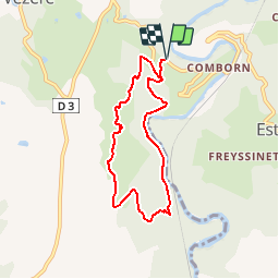
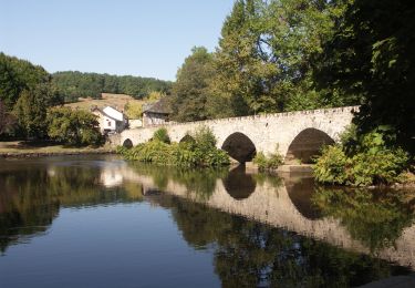
Ruta Senderismo de 6,7 km a descubrir en Nueva Aquitania, Corrèze, Orgnac-sur-Vézère. Esta ruta ha sido propuesta por houbart.
Descripción
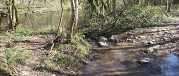
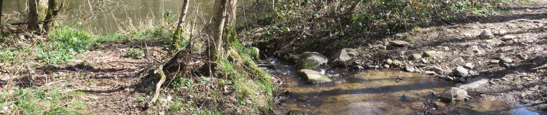
Départ de l'aire de pique-nique sur la route (D9E2) de Comborn. Plusieurs gués à passer le long de la Vézère.
Localización
País:
France
Región :
Nueva Aquitania
Departamento/provincia :
Corrèze
Municipio :
Orgnac-sur-Vézère
Localidad:
Unknown
Salida:(Dec)
Salida:(UTM)
379759 ; 5019989 (31T) N.
Comentarios
Excursiones cerca
![Excursión Senderismo Saint-Bonnet-l'Enfantier - Fred BC st bonnet l enfantier - Photo](https://media.geolcdn.com/t/375/260/fc207c1c-36d3-460d-b658-91346cacf652.jpg&format=jpg&maxdim=2)
![Senderismo Senderismo](https://static1.geolcdn.com/sitytour/trail-icons/101.png)
Fred BC st bonnet l enfantier
Senderismo
Medio
Saint-Bonnet-l'Enfantier,
Nueva Aquitania,
Corrèze,
France
![](/images/other/stat-length.png)
9,1 km | 11,5 km-effort
3h 17min
![](https://static1.geolcdn.com/siteimages/upload/files/16400158638029165_repeat_loop_refresh_sync_direction_icon.png)
Sí
![Senderismo Senderismo](https://static1.geolcdn.com/sitytour/trail-icons/101.png)
Estivaux_Le Saillant-Gorges de la Vézère
Senderismo
Difícil
Estivaux,
Nueva Aquitania,
Corrèze,
France
![](/images/other/stat-length.png)
20 km | 30 km-effort
6h 0min
![](https://static1.geolcdn.com/siteimages/upload/files/16400158638029165_repeat_loop_refresh_sync_direction_icon.png)
Sí
![Excursión Senderismo Voutezac - Ayen-160623 - Ceyrat-FontaineCrozes - Photo](https://media.geolcdn.com/t/375/260/ext.jpg?maxdim=2&url=https%3A%2F%2Fservices.sitytrail.com%2FGeolivesWS%2FDownloadMedia.ashx%3FTrailID%3D588114%26Media%3Dfix__20160623115501.jpg)
![Senderismo Senderismo](https://static1.geolcdn.com/sitytour/trail-icons/101.png)
Ayen-160623 - Ceyrat-FontaineCrozes
Senderismo
Medio
Voutezac,
Nueva Aquitania,
Corrèze,
France
![](/images/other/stat-length.png)
7,5 km | 10,7 km-effort
2h 35min
![](https://static1.geolcdn.com/siteimages/upload/files/16400158638029165_repeat_loop_refresh_sync_direction_icon.png)
Sí
![Excursión Senderismo Voutezac - Les coteaux de Vertougit - Voutezac - Photo](https://media.geolcdn.com/t/375/260/ext.jpg?maxdim=2&url=https%3A%2F%2Fservices.sitytrail.com%2FGeolivesWS%2FDownloadMedia.ashx%3FTrailID%3D318028%26Media%3D17491_3.jpg)
![Senderismo Senderismo](https://static1.geolcdn.com/sitytour/trail-icons/101.png)
Les coteaux de Vertougit - Voutezac
Senderismo
Medio
Voutezac,
Nueva Aquitania,
Corrèze,
France
![](/images/other/stat-length.png)
10,9 km | 15,3 km-effort
3h 30min
![](https://static1.geolcdn.com/siteimages/upload/files/16400158638029165_repeat_loop_refresh_sync_direction_icon.png)
Sí
![Excursión Senderismo Voutezac - La fontaine des Crozes - Voutezac - Photo](https://media.geolcdn.com/t/375/260/ext.jpg?maxdim=2&url=https%3A%2F%2Fservices.sitytrail.com%2FGeolivesWS%2FDownloadMedia.ashx%3FTrailID%3D318027%26Media%3D17490_3.jpg)
![Senderismo Senderismo](https://static1.geolcdn.com/sitytour/trail-icons/101.png)
La fontaine des Crozes - Voutezac
Senderismo
Difícil
(1)
Voutezac,
Nueva Aquitania,
Corrèze,
France
![](/images/other/stat-length.png)
11,8 km | 16,7 km-effort
3h 0min
![](https://static1.geolcdn.com/siteimages/upload/files/16400158638029165_repeat_loop_refresh_sync_direction_icon.png)
Sí
![Excursión Moto Allassac - Rocher du diable - Photo](https://media.geolcdn.com/t/375/260/0a13996c-2b51-4b44-aa5b-663accdc6b35.jpg&format=jpg&maxdim=2)
![Moto Moto](https://static1.geolcdn.com/sitytour/trail-icons/402.png)
Rocher du diable
Moto
Muy difícil
Allassac,
Nueva Aquitania,
Corrèze,
France
![](/images/other/stat-length.png)
3,8 km | 5,4 km-effort
28min
![](https://static1.geolcdn.com/siteimages/upload/files/16400158638029165_repeat_loop_refresh_sync_direction_icon.png)
No
![Senderismo Senderismo](https://static1.geolcdn.com/sitytour/trail-icons/101.png)
Gorges de la Vézère : Boucle Comborn-le Saillant
Senderismo
Muy difícil
Orgnac-sur-Vézère,
Nueva Aquitania,
Corrèze,
France
![](/images/other/stat-length.png)
21 km | 32 km-effort
7h 13min
![](https://static1.geolcdn.com/siteimages/upload/files/16400158638029165_repeat_loop_refresh_sync_direction_icon.png)
Sí
![Excursión Senderismo Voutezac - saillant - Photo](https://media.geolcdn.com/t/375/260/92ea7a9c-fe1b-4e0e-8888-a7e07b3090ca.jpg&format=jpg&maxdim=2)
![Senderismo Senderismo](https://static1.geolcdn.com/sitytour/trail-icons/101.png)
saillant
Senderismo
Fácil
Voutezac,
Nueva Aquitania,
Corrèze,
France
![](/images/other/stat-length.png)
10,9 km | 16,6 km-effort
3h 11min
![](https://static1.geolcdn.com/siteimages/upload/files/16400158638029165_repeat_loop_refresh_sync_direction_icon.png)
Sí
![Excursión Senderismo Beyssac - Beyssac (19230)- Chartreuse du Glandier et Canal des moines - Photo](https://media.geolcdn.com/t/375/260/ext.jpg?maxdim=2&url=https%3A%2F%2Fservices.sitytrail.com%2FGeolivesWS%2FDownloadMedia.ashx%3FTrailID%3D1049026%26Media%3D8558f252-1a38-414b-9a0d-e1468deabb1c.JPG)
![Senderismo Senderismo](https://static1.geolcdn.com/sitytour/trail-icons/101.png)
Beyssac (19230)- Chartreuse du Glandier et Canal des moines
Senderismo
Muy fácil
(1)
Beyssac,
Nueva Aquitania,
Corrèze,
France
![](/images/other/stat-length.png)
4,6 km | 6,4 km-effort
1h 13min
![](https://static1.geolcdn.com/siteimages/upload/files/16400158638029165_repeat_loop_refresh_sync_direction_icon.png)
Sí