![](/images/other/stat-length.png)
![Excursión Senderismo Tréhorenteuc - La Porte du Ciel - Tréhorenteuc - Photo](https://media.geolcdn.com/t/1900/400/ext.pjpeg?maxdim=2&url=https%3A%2F%2Fstatic1.geolcdn.com%2Fsiteimages%2Fupload%2Ffiles%2F1553511878bg_sport_marche.png)
La Porte du Ciel - Tréhorenteuc
tracegps
Usuario
![Longitud](/images/other/stat-length.png)
![Altitud máxima](https://static1.geolcdn.com/siteimages/upload/files/1508320355ic_sort_altitude_max_24dp.png)
![Desnivel positivo](https://static1.geolcdn.com/siteimages/upload/files/1508320355ic_sort_den_pos_24dp.png)
![Km-Effort](/images/other/stat-length.png)
![Altitud mínima](https://static1.geolcdn.com/siteimages/upload/files/1508320355ic_sort_altitude_min_24dp.png)
![Desnivel negativo](https://static1.geolcdn.com/siteimages/upload/files/1508320355ic_sort_den_neg_24dp.png)
![Boucle](https://static1.geolcdn.com/siteimages/upload/files/16400158638029165_repeat_loop_refresh_sync_direction_icon.png)
![Senderismo](https://static1.geolcdn.com/sitytour/trail-icons/101.png)
4h00
Dificultad : Medio
![Escanee este código QR para abrir la excursión en la aplicación SityTrail](https://capi.geolives.com/qq0zvz2zws4bq2lad0pu/sitytour/trails/112535/qr.png?size=200)
Aplicación GPS de excursión GRATIS
A propósito
Ruta Senderismo de 16 km a descubrir en Bretaña, Morbihan, Tréhorenteuc. Esta ruta ha sido propuesta por tracegps.
Descripción
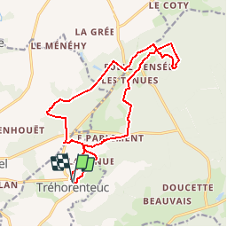
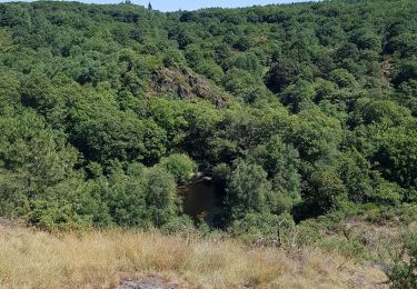
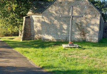
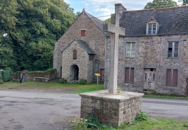
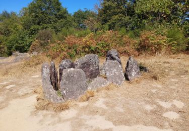
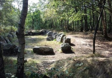
Point de départ : église de Tréhorenteuc - Coordonnées GPS : 02°17’14’’O / 48°00’28’’N - Distance : 15 km – 4 h 00 A voir en chemin: 1. Église de Tréhorenteuc : rénovée par l’Abbé Gillard dès 1942, cette petite église est un véritable musée du Graal. Elle abrite 3 symboliques (chrétienne, celte et légendaire) qui s’entremêlent dans les tableaux, mosaïques, vitraux, nous permettant d’entrevoir la signification de la phrase mystérieuse écrite au-dessus de la porte, « La Porte est en dedans »… Une visite s’impose ! 2. Fontaine de Barenton : lieu de rencontre entre Merlin et Viviane et centre de l’action du roman Yvain le Chevalier au Lion (Chrétien de Troyes, XIIème siècle). Gare aux imprudents : on déclenche ici des orages terribles, en arrosant la margelle. Les druides y soignaient les malades mentaux (d’où le nom du village de Folle Pensée à proximité). 3. Tumulus du Jardin aux Moines : site mégalithique composé de blocs de schiste rouge et de quartzite blanc. La partie la plus ancienne daterait de 4000 ans, au début de l’âge du bronze. On y retrouve des êtres indélicats pétrifiés : certains disent que ce seraient des religieux menant une vie de débauche, d’autres qu’il s’agirait d’un seigneur de Tréhorenteuc et sa bande qui auraient engagé une sauvage chasse à courre le jour de la fête des morts... Office de tourisme du pays de Mauron en Brocéliande. Tel : 02 97 93 05 12 - Email : tourisme (at) valsansretour.com
Localización
Comentarios
Excursiones cerca
![Excursión Paseo ecuestre Néant-sur-Yvel - Broceliande - Photo](https://media.geolcdn.com/t/375/260/203abf06-19c3-4c8f-9ce2-990712cb0787.jpg&format=jpg&maxdim=2)
![Paseo ecuestre Paseo ecuestre](https://static1.geolcdn.com/sitytour/trail-icons/301.png)
Paseo ecuestre
![](/images/other/stat-length.png)
![](https://static1.geolcdn.com/siteimages/upload/files/16400158638029165_repeat_loop_refresh_sync_direction_icon.png)
![Excursión Senderismo Campénéac - Château de TRECESSON - Tombeau du Géant - L'Hotié de la Fée Viviane - (8/2019) - Photo](https://media.geolcdn.com/t/375/260/6dc55585-1341-4962-8006-32206bea207b.jpg&format=jpg&maxdim=2)
![Senderismo Senderismo](https://static1.geolcdn.com/sitytour/trail-icons/101.png)
Senderismo
![](/images/other/stat-length.png)
![](https://static1.geolcdn.com/siteimages/upload/files/16400158638029165_repeat_loop_refresh_sync_direction_icon.png)
![Excursión Senderismo Tréhorenteuc - les landes de Gurwant et le Val sans retour - Photo](https://media.geolcdn.com/t/375/260/8ebdb65c-0df1-4e76-a908-0321b1ff5945.jpg&format=jpg&maxdim=2)
![Senderismo Senderismo](https://static1.geolcdn.com/sitytour/trail-icons/101.png)
Senderismo
![](/images/other/stat-length.png)
![](https://static1.geolcdn.com/siteimages/upload/files/16400158638029165_repeat_loop_refresh_sync_direction_icon.png)
![Excursión Senderismo Tréhorenteuc - Tréhorenteuc - Photo](https://media.geolcdn.com/t/375/260/d78e64c2-e4c4-446d-80e9-2d94e7737353.jpg&format=jpg&maxdim=2)
![Senderismo Senderismo](https://static1.geolcdn.com/sitytour/trail-icons/101.png)
![Excursión Senderismo Mauron - GR_37_CF_40_Mauron_Taupont_20220925 - Photo](https://media.geolcdn.com/t/375/260/5934c0c6-bee8-44fc-9fe2-148a0c004337.jpg&format=jpg&maxdim=2)
![Senderismo Senderismo](https://static1.geolcdn.com/sitytour/trail-icons/101.png)
Senderismo
![](/images/other/stat-length.png)
![](https://static1.geolcdn.com/siteimages/upload/files/16400158638029165_repeat_loop_refresh_sync_direction_icon.png)
![Excursión Senderismo Paimpont - GR_37_CE_39_Paimpont_Mauron_20220924 - Photo](https://media.geolcdn.com/t/375/260/d0e9fad4-0af6-4e10-b643-661a6c1313a8.jpg&format=jpg&maxdim=2)
![Senderismo Senderismo](https://static1.geolcdn.com/sitytour/trail-icons/101.png)
Senderismo
![](/images/other/stat-length.png)
![](https://static1.geolcdn.com/siteimages/upload/files/16400158638029165_repeat_loop_refresh_sync_direction_icon.png)
![Excursión Senderismo Tréhorenteuc - Broceliande - Photo](https://media.geolcdn.com/t/375/260/81018fdd-76b5-4b1a-8652-c9a532731623.jpg&format=jpg&maxdim=2)
![Senderismo Senderismo](https://static1.geolcdn.com/sitytour/trail-icons/101.png)
Senderismo
![](/images/other/stat-length.png)
![](https://static1.geolcdn.com/siteimages/upload/files/16400158638029165_repeat_loop_refresh_sync_direction_icon.png)
![Excursión A pie Campénéac - Les Landes de Gurwan - Photo](https://media.geolcdn.com/t/375/260/b737382d-2b17-4f2d-90a4-5777864a81d4.jpeg&format=jpg&maxdim=2)
![A pie A pie](https://static1.geolcdn.com/sitytour/trail-icons/100.png)
A pie
![](/images/other/stat-length.png)
![](https://static1.geolcdn.com/siteimages/upload/files/16400158638029165_repeat_loop_refresh_sync_direction_icon.png)
![Excursión Senderismo Néant-sur-Yvel - TUMULUS DU JARDIN AUX MOINES (9/20) - Photo](https://media.geolcdn.com/t/375/260/7bb9903b-d90a-4ad2-bb6c-2c00df8bd974.jpg&format=jpg&maxdim=2)
![Senderismo Senderismo](https://static1.geolcdn.com/sitytour/trail-icons/101.png)
Senderismo
![](/images/other/stat-length.png)
![](https://static1.geolcdn.com/siteimages/upload/files/16400158638029165_repeat_loop_refresh_sync_direction_icon.png)
parcours tres sympathique