![](/images/other/stat-length.png)
![Excursión Senderismo Chaux-lès-Passavant - sur les terres de Louis Pergaud. - Chaux passavant - Photo](https://media.geolcdn.com/t/1900/400/ext.pjpeg?maxdim=2&url=https%3A%2F%2Fstatic1.geolcdn.com%2Fsiteimages%2Fupload%2Ffiles%2F1553511878bg_sport_marche.png)
sur les terres de Louis Pergaud. - Chaux passavant
eltonnermou
Usuario
![Longitud](/images/other/stat-length.png)
Longitud
14,7 km
![Altitud máxima](https://static1.geolcdn.com/siteimages/upload/files/1508320355ic_sort_altitude_max_24dp.png)
Altitud máxima
612 m
![Desnivel positivo](https://static1.geolcdn.com/siteimages/upload/files/1508320355ic_sort_den_pos_24dp.png)
Desnivel positivo
231 m
![Km-Effort](/images/other/stat-length.png)
Km-Effort
17,7 km
![Altitud mínima](https://static1.geolcdn.com/siteimages/upload/files/1508320355ic_sort_altitude_min_24dp.png)
Altitud mínima
499 m
![Desnivel negativo](https://static1.geolcdn.com/siteimages/upload/files/1508320355ic_sort_den_neg_24dp.png)
Desnivel negativo
231 m
![Boucle](https://static1.geolcdn.com/siteimages/upload/files/16400158638029165_repeat_loop_refresh_sync_direction_icon.png)
Boucle
Sí
Fecha de creación :
2019-05-06 22:29:56.066
Última modificación :
2019-05-06 22:29:56.066
![Senderismo](https://static1.geolcdn.com/sitytour/trail-icons/101.png)
2h23
Dificultad : Medio
![Escanee este código QR para abrir la excursión en la aplicación SityTrail](https://capi.geolives.com/qq0zvz2zws4bq2lad0pu/sitytour/trails/1119914/qr.png?size=200)
Aplicación GPS de excursión GRATIS
A propósito
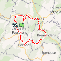
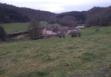
Ruta Senderismo de 14,7 km a descubrir en Borgoña-Franco Condado, Doubs, Chaux-lès-Passavant. Esta ruta ha sido propuesta por eltonnermou.
Descripción
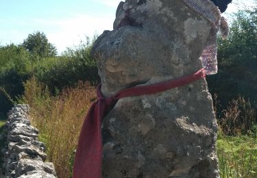
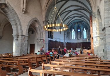
beaucoup de sentiers routes (très calmes), randonnée à travers prairies et bois, quelques belles demeures, 3 beaux belvédères sur l'audeux.
Localización
País:
France
Región :
Borgoña-Franco Condado
Departamento/provincia :
Doubs
Municipio :
Chaux-lès-Passavant
Localidad:
Unknown
Salida:(Dec)
Salida:(UTM)
300036 ; 5234826 (32T) N.
Comentarios
Excursiones cerca
![Excursión Senderismo - aissey - Photo](https://media.geolcdn.com/t/375/260/d2f9f8ee-468c-49d5-a74e-0ffbcd469a5c.jpg&format=jpg&maxdim=2)
![Senderismo Senderismo](https://static1.geolcdn.com/sitytour/trail-icons/101.png)
aissey
Senderismo
Muy difícil
(1)
,
Borgoña-Franco Condado,
Doubs,
France
![](/images/other/stat-length.png)
18,2 km | 23 km-effort
5h 17min
![](https://static1.geolcdn.com/siteimages/upload/files/16400158638029165_repeat_loop_refresh_sync_direction_icon.png)
Sí
![Excursión A pie - L'Abbaye de Grâce-Dieu - Photo](https://media.geolcdn.com/t/375/260/e7047298-0680-4d34-84a3-c0c34f4c6e9f.jpeg&format=jpg&maxdim=2)
![A pie A pie](https://static1.geolcdn.com/sitytour/trail-icons/100.png)
L'Abbaye de Grâce-Dieu
A pie
Fácil
,
Borgoña-Franco Condado,
Doubs,
France
![](/images/other/stat-length.png)
12,5 km | 17,4 km-effort
3h 57min
![](https://static1.geolcdn.com/siteimages/upload/files/16400158638029165_repeat_loop_refresh_sync_direction_icon.png)
Sí
![Excursión Senderismo Chaux-lès-Passavant - grâce diable - Photo](https://media.geolcdn.com/t/375/260/3906cd7f-8baa-4f7d-b4ba-81e39160b911.jpg&format=jpg&maxdim=2)
![Senderismo Senderismo](https://static1.geolcdn.com/sitytour/trail-icons/101.png)
grâce diable
Senderismo
Muy fácil
Chaux-lès-Passavant,
Borgoña-Franco Condado,
Doubs,
France
![](/images/other/stat-length.png)
7,7 km | 9,9 km-effort
1h 16min
![](https://static1.geolcdn.com/siteimages/upload/files/16400158638029165_repeat_loop_refresh_sync_direction_icon.png)
Sí
![Excursión Senderismo Chaux-lès-Passavant - grâce diable retour par coteau opposé - Photo](https://media.geolcdn.com/t/375/260/43b503a9-1ee4-4f7f-8af2-470efd4cb143.jpg&format=jpg&maxdim=2)
![Senderismo Senderismo](https://static1.geolcdn.com/sitytour/trail-icons/101.png)
grâce diable retour par coteau opposé
Senderismo
Fácil
Chaux-lès-Passavant,
Borgoña-Franco Condado,
Doubs,
France
![](/images/other/stat-length.png)
8,5 km | 11,1 km-effort
2h 11min
![](https://static1.geolcdn.com/siteimages/upload/files/16400158638029165_repeat_loop_refresh_sync_direction_icon.png)
Sí
![Excursión Senderismo Eysson - Eysson Moulin de Creuse 1 août 2019 CAF - Photo](https://media.geolcdn.com/t/375/260/5ca7af0d-da65-48eb-aa17-a0a013cc4d8f.jpg&format=jpg&maxdim=2)
![Senderismo Senderismo](https://static1.geolcdn.com/sitytour/trail-icons/101.png)
Eysson Moulin de Creuse 1 août 2019 CAF
Senderismo
Difícil
Eysson,
Borgoña-Franco Condado,
Doubs,
France
![](/images/other/stat-length.png)
19,6 km | 26 km-effort
7h 14min
![](https://static1.geolcdn.com/siteimages/upload/files/16400158638029165_repeat_loop_refresh_sync_direction_icon.png)
Sí
![Excursión Senderismo Gonsans - 14 juillet 2023 - Photo](https://media.geolcdn.com/t/375/260/ext.jpg?maxdim=2&url=https%3A%2F%2Fstatic1.geolcdn.com%2Fsiteimages%2Fupload%2Ffiles%2F1553511878bg_sport_marche.png)
![Senderismo Senderismo](https://static1.geolcdn.com/sitytour/trail-icons/101.png)
14 juillet 2023
Senderismo
Medio
Gonsans,
Borgoña-Franco Condado,
Doubs,
France
![](/images/other/stat-length.png)
6,2 km | 7,7 km-effort
2h 3min
![](https://static1.geolcdn.com/siteimages/upload/files/16400158638029165_repeat_loop_refresh_sync_direction_icon.png)
Sí
![Excursión Senderismo Chaux-lès-Passavant - Abbaye Grâce Dieu Glacière et belvédères et visites - Photo](https://media.geolcdn.com/t/375/260/ae3d9a5f-3eb4-4836-ad72-16e0db1c63e1.jpg&format=jpg&maxdim=2)
![Senderismo Senderismo](https://static1.geolcdn.com/sitytour/trail-icons/101.png)
Abbaye Grâce Dieu Glacière et belvédères et visites
Senderismo
Fácil
Chaux-lès-Passavant,
Borgoña-Franco Condado,
Doubs,
France
![](/images/other/stat-length.png)
9,1 km | 11,5 km-effort
3h 56min
![](https://static1.geolcdn.com/siteimages/upload/files/16400158638029165_repeat_loop_refresh_sync_direction_icon.png)
Sí
![Excursión Bici de montaña Gonsans - Vélo gonsans - Photo](https://media.geolcdn.com/t/375/260/ext.jpg?maxdim=2&url=https%3A%2F%2Fstatic1.geolcdn.com%2Fsiteimages%2Fupload%2Ffiles%2F1524743154velo.jpg)
![Bici de montaña Bici de montaña](https://static1.geolcdn.com/sitytour/trail-icons/202.png)
Vélo gonsans
Bici de montaña
Fácil
Gonsans,
Borgoña-Franco Condado,
Doubs,
France
![](/images/other/stat-length.png)
12,3 km | 15,3 km-effort
1h 29min
![](https://static1.geolcdn.com/siteimages/upload/files/16400158638029165_repeat_loop_refresh_sync_direction_icon.png)
Sí
![Excursión Senderismo Gonsans - Gonsans 7 - Photo](https://media.geolcdn.com/t/375/260/ext.jpg?maxdim=2&url=https%3A%2F%2Fstatic1.geolcdn.com%2Fsiteimages%2Fupload%2Ffiles%2F1553511878bg_sport_marche.png)
![Senderismo Senderismo](https://static1.geolcdn.com/sitytour/trail-icons/101.png)
Gonsans 7
Senderismo
Medio
Gonsans,
Borgoña-Franco Condado,
Doubs,
France
![](/images/other/stat-length.png)
8,6 km | 10,1 km-effort
1h 56min
![](https://static1.geolcdn.com/siteimages/upload/files/16400158638029165_repeat_loop_refresh_sync_direction_icon.png)
Sí