![](/images/other/stat-length.png)
![Excursión Senderismo Chanteloup - Le chant des Loups - Chanteloup - Photo](https://media.geolcdn.com/t/1900/400/ext.pjpeg?maxdim=2&url=https%3A%2F%2Fservices.sitytrail.com%2FGeolivesWS%2FDownloadMedia.ashx%3FTrailID%3D111880%26Media%3D8727_2.jpg)
Le chant des Loups - Chanteloup
tracegps
Usuario
![Longitud](/images/other/stat-length.png)
Longitud
9 km
![Altitud máxima](https://static1.geolcdn.com/siteimages/upload/files/1508320355ic_sort_altitude_max_24dp.png)
Altitud máxima
72 m
![Desnivel positivo](https://static1.geolcdn.com/siteimages/upload/files/1508320355ic_sort_den_pos_24dp.png)
Desnivel positivo
106 m
![Km-Effort](/images/other/stat-length.png)
Km-Effort
10,4 km
![Altitud mínima](https://static1.geolcdn.com/siteimages/upload/files/1508320355ic_sort_altitude_min_24dp.png)
Altitud mínima
25 m
![Desnivel negativo](https://static1.geolcdn.com/siteimages/upload/files/1508320355ic_sort_den_neg_24dp.png)
Desnivel negativo
106 m
![Boucle](https://static1.geolcdn.com/siteimages/upload/files/16400158638029165_repeat_loop_refresh_sync_direction_icon.png)
Boucle
Sí
Fecha de creación :
2014-12-10 00:00:00.0
Última modificación :
2014-12-10 00:00:00.0
![Senderismo](https://static1.geolcdn.com/sitytour/trail-icons/101.png)
2h00
Dificultad : Medio
![Escanee este código QR para abrir la excursión en la aplicación SityTrail](https://capi.geolives.com/qq0zvz2zws4bq2lad0pu/sitytour/trails/111880/qr.png?size=200)
Aplicación GPS de excursión GRATIS
A propósito
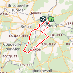
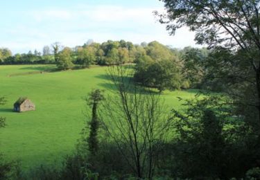
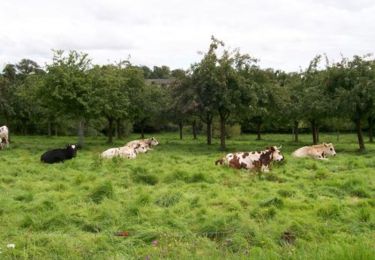
Ruta Senderismo de 9 km a descubrir en Normandía, Mancha, Chanteloup. Esta ruta ha sido propuesta por tracegps.
Descripción
Départ de la place de la mairie de Chanteloup vers le village Duprey puis le Mesnil et retour par le Village Bouillon et Le Gaillarbois.
Localización
País:
France
Región :
Normandía
Departamento/provincia :
Mancha
Municipio :
Chanteloup
Localidad:
Unknown
Salida:(Dec)
Salida:(UTM)
610928 ; 5417318 (30U) N.
Comentarios
Excursiones cerca
![Excursión Senderismo Cérences - Le Moulin de Guelle - Cérences - Photo](https://media.geolcdn.com/t/375/260/ext.jpg?maxdim=2&url=https%3A%2F%2Fservices.sitytrail.com%2FGeolivesWS%2FDownloadMedia.ashx%3FTrailID%3D111861%26Media%3D8638_3.jpg)
![Senderismo Senderismo](https://static1.geolcdn.com/sitytour/trail-icons/101.png)
Le Moulin de Guelle - Cérences
Senderismo
Medio
Cérences,
Normandía,
Mancha,
France
![](/images/other/stat-length.png)
12,6 km | 15,8 km-effort
3h 0min
![](https://static1.geolcdn.com/siteimages/upload/files/16400158638029165_repeat_loop_refresh_sync_direction_icon.png)
Sí
![Excursión Paseo ecuestre Lingreville - Balade Sarah samedi - Photo](https://media.geolcdn.com/t/375/260/1ff22927-12ef-4acd-8c7d-2098b1cdad3c.jpg&format=jpg&maxdim=2)
![Paseo ecuestre Paseo ecuestre](https://static1.geolcdn.com/sitytour/trail-icons/301.png)
Balade Sarah samedi
Paseo ecuestre
Medio
Lingreville,
Normandía,
Mancha,
France
![](/images/other/stat-length.png)
19,7 km | 21 km-effort
45min
![](https://static1.geolcdn.com/siteimages/upload/files/16400158638029165_repeat_loop_refresh_sync_direction_icon.png)
Sí
![Excursión Bici de montaña Cérences - VTT de Cérences à Beauchamps - Photo](https://media.geolcdn.com/t/375/260/ext.jpg?maxdim=2&url=https%3A%2F%2Fservices.sitytrail.com%2FGeolivesWS%2FDownloadMedia.ashx%3FTrailID%3D172449%26Media%3D13805_1.jpg)
![Bici de montaña Bici de montaña](https://static1.geolcdn.com/sitytour/trail-icons/202.png)
VTT de Cérences à Beauchamps
Bici de montaña
Muy difícil
Cérences,
Normandía,
Mancha,
France
![](/images/other/stat-length.png)
52 km | 65 km-effort
4h 0min
![](https://static1.geolcdn.com/siteimages/upload/files/16400158638029165_repeat_loop_refresh_sync_direction_icon.png)
Sí
![Excursión Senderismo Hudimesnil - Le Moulin du Pont - Hudimesnil - Photo](https://media.geolcdn.com/t/375/260/ext.jpg?maxdim=2&url=https%3A%2F%2Fservices.sitytrail.com%2FGeolivesWS%2FDownloadMedia.ashx%3FTrailID%3D111879%26Media%3D8726_1.jpg)
![Senderismo Senderismo](https://static1.geolcdn.com/sitytour/trail-icons/101.png)
Le Moulin du Pont - Hudimesnil
Senderismo
Medio
(1)
Hudimesnil,
Normandía,
Mancha,
France
![](/images/other/stat-length.png)
14,8 km | 17,3 km-effort
3h 30min
![](https://static1.geolcdn.com/siteimages/upload/files/16400158638029165_repeat_loop_refresh_sync_direction_icon.png)
Sí
![Excursión Senderismo Hudimesnil - La Chapelle Sainte Suzanne - Hudimesnil - Photo](https://media.geolcdn.com/t/375/260/ext.jpg?maxdim=2&url=https%3A%2F%2Fservices.sitytrail.com%2FGeolivesWS%2FDownloadMedia.ashx%3FTrailID%3D111877%26Media%3D8720_1.jpg)
![Senderismo Senderismo](https://static1.geolcdn.com/sitytour/trail-icons/101.png)
La Chapelle Sainte Suzanne - Hudimesnil
Senderismo
Medio
Hudimesnil,
Normandía,
Mancha,
France
![](/images/other/stat-length.png)
5,2 km | 6,2 km-effort
1h 4min
![](https://static1.geolcdn.com/siteimages/upload/files/16400158638029165_repeat_loop_refresh_sync_direction_icon.png)
Sí
![Excursión Senderismo Le Loreur - La jambe de Loup - Le Loreur - Photo](https://media.geolcdn.com/t/375/260/ext.jpg?maxdim=2&url=https%3A%2F%2Fservices.sitytrail.com%2FGeolivesWS%2FDownloadMedia.ashx%3FTrailID%3D111866%26Media%3D8669_1.jpg)
![Senderismo Senderismo](https://static1.geolcdn.com/sitytour/trail-icons/101.png)
La jambe de Loup - Le Loreur
Senderismo
Medio
Le Loreur,
Normandía,
Mancha,
France
![](/images/other/stat-length.png)
7 km | 8,3 km-effort
1h 30min
![](https://static1.geolcdn.com/siteimages/upload/files/16400158638029165_repeat_loop_refresh_sync_direction_icon.png)
Sí
![Excursión Senderismo Cérences - La Voie Romaine - Cérences - Photo](https://media.geolcdn.com/t/375/260/ext.jpg?maxdim=2&url=https%3A%2F%2Fservices.sitytrail.com%2FGeolivesWS%2FDownloadMedia.ashx%3FTrailID%3D111865%26Media%3D8668_1.jpg)
![Senderismo Senderismo](https://static1.geolcdn.com/sitytour/trail-icons/101.png)
La Voie Romaine - Cérences
Senderismo
Medio
Cérences,
Normandía,
Mancha,
France
![](/images/other/stat-length.png)
6,6 km | 7,7 km-effort
1h 30min
![](https://static1.geolcdn.com/siteimages/upload/files/16400158638029165_repeat_loop_refresh_sync_direction_icon.png)
Sí
![Excursión Senderismo Cérences - Entre Batterel et Sienne - Cérences - Photo](https://media.geolcdn.com/t/375/260/ext.jpg?maxdim=2&url=https%3A%2F%2Fservices.sitytrail.com%2FGeolivesWS%2FDownloadMedia.ashx%3FTrailID%3D111864%26Media%3D8667_1.jpg)
![Senderismo Senderismo](https://static1.geolcdn.com/sitytour/trail-icons/101.png)
Entre Batterel et Sienne - Cérences
Senderismo
Medio
Cérences,
Normandía,
Mancha,
France
![](/images/other/stat-length.png)
11,7 km | 14 km-effort
2h 19min
![](https://static1.geolcdn.com/siteimages/upload/files/16400158638029165_repeat_loop_refresh_sync_direction_icon.png)
Sí
![Excursión Senderismo Cérences - Les Vallons de Cérences - Photo](https://media.geolcdn.com/t/375/260/ext.jpg?maxdim=2&url=https%3A%2F%2Fservices.sitytrail.com%2FGeolivesWS%2FDownloadMedia.ashx%3FTrailID%3D111863%26Media%3D8666_1.jpg)
![Senderismo Senderismo](https://static1.geolcdn.com/sitytour/trail-icons/101.png)
Les Vallons de Cérences
Senderismo
Medio
Cérences,
Normandía,
Mancha,
France
![](/images/other/stat-length.png)
19,3 km | 23 km-effort
4h 15min
![](https://static1.geolcdn.com/siteimages/upload/files/16400158638029165_repeat_loop_refresh_sync_direction_icon.png)
Sí