![](/images/other/stat-length.png)
![Excursión Senderismo Campénéac - Circuit des Landes Rennaises - Campénéac - Photo](https://media.geolcdn.com/t/1900/400/ext.pjpeg?maxdim=2&url=https%3A%2F%2Fservices.sitytrail.com%2FGeolivesWS%2FDownloadMedia.ashx%3FTrailID%3D111741%26Media%3D8143_5.jpg)
Circuit des Landes Rennaises - Campénéac
tracegps
Usuario
![Longitud](/images/other/stat-length.png)
![Altitud máxima](https://static1.geolcdn.com/siteimages/upload/files/1508320355ic_sort_altitude_max_24dp.png)
![Desnivel positivo](https://static1.geolcdn.com/siteimages/upload/files/1508320355ic_sort_den_pos_24dp.png)
![Km-Effort](/images/other/stat-length.png)
![Altitud mínima](https://static1.geolcdn.com/siteimages/upload/files/1508320355ic_sort_altitude_min_24dp.png)
![Desnivel negativo](https://static1.geolcdn.com/siteimages/upload/files/1508320355ic_sort_den_neg_24dp.png)
![Boucle](https://static1.geolcdn.com/siteimages/upload/files/16400158638029165_repeat_loop_refresh_sync_direction_icon.png)
![Senderismo](https://static1.geolcdn.com/sitytour/trail-icons/101.png)
3h04
Dificultad : Difícil
![Escanee este código QR para abrir la excursión en la aplicación SityTrail](https://capi.geolives.com/qq0zvz2zws4bq2lad0pu/sitytour/trails/111741/qr.png?size=200)
Aplicación GPS de excursión GRATIS
A propósito
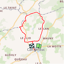
Ruta Senderismo de 12,2 km a descubrir en Bretaña, Morbihan, Campénéac. Esta ruta ha sido propuesta por tracegps.
Descripción
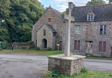
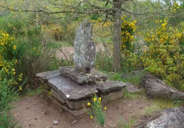
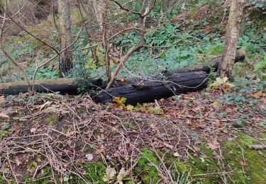
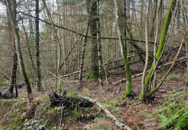
Circuit proposé par la communauté de communes de Ploërmel. Départ de l’église de Campénéac. Au sud de la forêt de Brocéliande, ce circuit vous conduit dans les landes de Campénéac d'où l'on voit les moulins de Rohan au milieu des ajoncs et des bruyères. Prenez le temps de faire une halte gourmande et spirituelle à l'Abbaye la Joie Notre Dame. Retrouvez le circuit sur le site du Pays Touristique de l’Oust à Brocéliande.
Localización
Comentarios
Excursiones cerca
![Excursión Senderismo Campénéac - Château de TRECESSON - Tombeau du Géant - L'Hotié de la Fée Viviane - (8/2019) - Photo](https://media.geolcdn.com/t/375/260/6dc55585-1341-4962-8006-32206bea207b.jpg&format=jpg&maxdim=2)
![Senderismo Senderismo](https://static1.geolcdn.com/sitytour/trail-icons/101.png)
Senderismo
![](/images/other/stat-length.png)
![](https://static1.geolcdn.com/siteimages/upload/files/16400158638029165_repeat_loop_refresh_sync_direction_icon.png)
![Excursión Senderismo Paimpont - GR_37_CE_39_Paimpont_Mauron_20220924 - Photo](https://media.geolcdn.com/t/375/260/d0e9fad4-0af6-4e10-b643-661a6c1313a8.jpg&format=jpg&maxdim=2)
![Senderismo Senderismo](https://static1.geolcdn.com/sitytour/trail-icons/101.png)
Senderismo
![](/images/other/stat-length.png)
![](https://static1.geolcdn.com/siteimages/upload/files/16400158638029165_repeat_loop_refresh_sync_direction_icon.png)
![Excursión A pie Campénéac - Les Landes de Gurwan - Photo](https://media.geolcdn.com/t/375/260/b737382d-2b17-4f2d-90a4-5777864a81d4.jpeg&format=jpg&maxdim=2)
![A pie A pie](https://static1.geolcdn.com/sitytour/trail-icons/100.png)
A pie
![](/images/other/stat-length.png)
![](https://static1.geolcdn.com/siteimages/upload/files/16400158638029165_repeat_loop_refresh_sync_direction_icon.png)
![Excursión Senderismo Campénéac - l'arbre d'or Val sans retour - Photo](https://media.geolcdn.com/t/375/260/1799521b-97a1-40bd-ba1e-99ab40d78482.jpg&format=jpg&maxdim=2)
![Senderismo Senderismo](https://static1.geolcdn.com/sitytour/trail-icons/101.png)
Senderismo
![](/images/other/stat-length.png)
![](https://static1.geolcdn.com/siteimages/upload/files/16400158638029165_repeat_loop_refresh_sync_direction_icon.png)
![Excursión Senderismo Paimpont - Paimpont 1 - Photo](https://media.geolcdn.com/t/375/260/83bfaa3b-4047-4ce0-8e02-90ebcbcc185a.jpg&format=jpg&maxdim=2)
![Senderismo Senderismo](https://static1.geolcdn.com/sitytour/trail-icons/101.png)
Senderismo
![](/images/other/stat-length.png)
![](https://static1.geolcdn.com/siteimages/upload/files/16400158638029165_repeat_loop_refresh_sync_direction_icon.png)
![Excursión Senderismo Campénéac - campe2 - Photo](https://media.geolcdn.com/t/375/260/7199eabc-bee6-4cb5-bea0-8b880964cd40.jpg&format=jpg&maxdim=2)
![Senderismo Senderismo](https://static1.geolcdn.com/sitytour/trail-icons/101.png)
![Excursión Carrera Campénéac - joie nd arbre d or val sans retour - Photo](https://media.geolcdn.com/t/375/260/c11e82d2-d80a-45d2-9e0c-433f6b59cdf3.jpg&format=jpg&maxdim=2)
![Carrera Carrera](https://static1.geolcdn.com/sitytour/trail-icons/103.png)
Carrera
![](/images/other/stat-length.png)
![](https://static1.geolcdn.com/siteimages/upload/files/16400158638029165_repeat_loop_refresh_sync_direction_icon.png)
![Excursión Senderismo Campénéac - campe - Photo](https://media.geolcdn.com/t/375/260/805b4dfd-5102-48a1-8e35-9b2469201689.jpg&format=jpg&maxdim=2)
![Senderismo Senderismo](https://static1.geolcdn.com/sitytour/trail-icons/101.png)
![Excursión Marcha nórdica Campénéac - CAMPENEAC 08-07-2012 - Photo](https://media.geolcdn.com/t/375/260/ext.jpg?maxdim=2&url=https%3A%2F%2Fstatic1.geolcdn.com%2Fsiteimages%2Fupload%2Ffiles%2F1545311037marcheuse_200dpi.jpg)
![Marcha nórdica Marcha nórdica](https://static1.geolcdn.com/sitytour/trail-icons/102.png)
Marcha nórdica
![](/images/other/stat-length.png)
![](https://static1.geolcdn.com/siteimages/upload/files/16400158638029165_repeat_loop_refresh_sync_direction_icon.png)