![](/images/other/stat-length.png)
![Excursión Senderismo Plessé - Circuit de la Marquise - Plessé - Photo](https://media.geolcdn.com/t/1900/400/ext.pjpeg?maxdim=2&url=https%3A%2F%2Fservices.sitytrail.com%2FGeolivesWS%2FDownloadMedia.ashx%3FTrailID%3D111706%26Media%3D8014_1.jpg)
Circuit de la Marquise - Plessé
tracegps
Usuario
![Longitud](/images/other/stat-length.png)
Longitud
11,8 km
![Altitud máxima](https://static1.geolcdn.com/siteimages/upload/files/1508320355ic_sort_altitude_max_24dp.png)
Altitud máxima
58 m
![Desnivel positivo](https://static1.geolcdn.com/siteimages/upload/files/1508320355ic_sort_den_pos_24dp.png)
Desnivel positivo
80 m
![Km-Effort](/images/other/stat-length.png)
Km-Effort
12,9 km
![Altitud mínima](https://static1.geolcdn.com/siteimages/upload/files/1508320355ic_sort_altitude_min_24dp.png)
Altitud mínima
26 m
![Desnivel negativo](https://static1.geolcdn.com/siteimages/upload/files/1508320355ic_sort_den_neg_24dp.png)
Desnivel negativo
80 m
![Boucle](https://static1.geolcdn.com/siteimages/upload/files/16400158638029165_repeat_loop_refresh_sync_direction_icon.png)
Boucle
Sí
Fecha de creación :
2014-12-10 00:00:00.0
Última modificación :
2014-12-10 00:00:00.0
![Senderismo](https://static1.geolcdn.com/sitytour/trail-icons/101.png)
3h00
Dificultad : Medio
![Escanee este código QR para abrir la excursión en la aplicación SityTrail](https://capi.geolives.com/qq0zvz2zws4bq2lad0pu/sitytour/trails/111706/qr.png?size=200)
Aplicación GPS de excursión GRATIS
A propósito
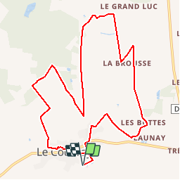
Ruta Senderismo de 11,8 km a descubrir en Países del Loira, Loira-Atlántico, Plessé. Esta ruta ha sido propuesta por tracegps.
Descripción
Circuit proposé par la maison du tourisme du Pays de Redon. Départ de l’aire de repos du hameau de Le Coudray de la commune de Plessé. Retrouvez le circuit sur le site du Pays de Redon.
Localización
País:
France
Región :
Países del Loira
Departamento/provincia :
Loira-Atlántico
Municipio :
Plessé
Localidad:
Unknown
Salida:(Dec)
Salida:(UTM)
587760 ; 5267595 (30T) N.
Comentarios
Excursiones cerca
![Excursión Senderismo Le Gâvre - 7.8.2019 Forêt du Gavre - Photo](https://media.geolcdn.com/t/375/260/f9cf14e8-928c-443f-a037-337d0befb490.jpg&format=jpg&maxdim=2)
![Senderismo Senderismo](https://static1.geolcdn.com/sitytour/trail-icons/101.png)
7.8.2019 Forêt du Gavre
Senderismo
Medio
Le Gâvre,
Países del Loira,
Loira-Atlántico,
France
![](/images/other/stat-length.png)
22 km | 25 km-effort
7h 48min
![](https://static1.geolcdn.com/siteimages/upload/files/16400158638029165_repeat_loop_refresh_sync_direction_icon.png)
Sí
![Excursión Senderismo Le Gâvre - 07.08.2019 - GÂVRE nord et Clégreuc - Photo](https://media.geolcdn.com/t/375/260/50e63918-d990-4d20-974b-f7cef55e5682.jpg&format=jpg&maxdim=2)
![Senderismo Senderismo](https://static1.geolcdn.com/sitytour/trail-icons/101.png)
07.08.2019 - GÂVRE nord et Clégreuc
Senderismo
Medio
Le Gâvre,
Países del Loira,
Loira-Atlántico,
France
![](/images/other/stat-length.png)
24 km | 27 km-effort
8h 8min
![](https://static1.geolcdn.com/siteimages/upload/files/16400158638029165_repeat_loop_refresh_sync_direction_icon.png)
Sí
![Excursión Senderismo Guémené-Penfao - 03.07.2019 - AUTOUR DE GUÉMENÉ-PENFAO - Photo](https://media.geolcdn.com/t/375/260/ac57c8d4-c307-429a-b3e2-ff98749136b0.jpg&format=jpg&maxdim=2)
![Senderismo Senderismo](https://static1.geolcdn.com/sitytour/trail-icons/101.png)
03.07.2019 - AUTOUR DE GUÉMENÉ-PENFAO
Senderismo
Difícil
Guémené-Penfao,
Países del Loira,
Loira-Atlántico,
France
![](/images/other/stat-length.png)
28 km | 0 m-effort
6h 55min
![](https://static1.geolcdn.com/siteimages/upload/files/16400158638029165_repeat_loop_refresh_sync_direction_icon.png)
Sí
![Excursión Caballo Le Gâvre - gavre072016 - Photo](https://media.geolcdn.com/t/375/260/ext.jpg?maxdim=2&url=https%3A%2F%2Fservices.sitytrail.com%2FGeolivesWS%2FDownloadMedia.ashx%3FTrailID%3D606974%26Media%3Dfix__20160701105728.jpg)
![Caballo Caballo](https://static1.geolcdn.com/sitytour/trail-icons/300.png)
gavre072016
Caballo
Muy fácil
Le Gâvre,
Países del Loira,
Loira-Atlántico,
France
![](/images/other/stat-length.png)
32 km | 36 km-effort
4h 36min
![](https://static1.geolcdn.com/siteimages/upload/files/16400158638029165_repeat_loop_refresh_sync_direction_icon.png)
Sí
![Excursión Caballo Le Gâvre - gavre juillet 2016 - Photo](https://media.geolcdn.com/t/375/260/ext.jpg?maxdim=2&url=https%3A%2F%2Fservices.sitytrail.com%2FGeolivesWS%2FDownloadMedia.ashx%3FTrailID%3D591466%26Media%3Dfix__20160701164833.jpg)
![Caballo Caballo](https://static1.geolcdn.com/sitytour/trail-icons/300.png)
gavre juillet 2016
Caballo
Muy fácil
Le Gâvre,
Países del Loira,
Loira-Atlántico,
France
![](/images/other/stat-length.png)
31 km | 35 km-effort
4h 31min
![](https://static1.geolcdn.com/siteimages/upload/files/16400158638029165_repeat_loop_refresh_sync_direction_icon.png)
Sí
![Excursión Coche Le Gâvre - 2024-10-29 RB l eGavre - Photo](https://media.geolcdn.com/t/375/260/ext.jpg?maxdim=2&url=https%3A%2F%2Fstatic1.geolcdn.com%2Fsiteimages%2Fupload%2Ffiles%2F15247431544x4.jpg)
![Coche Coche](https://static1.geolcdn.com/sitytour/trail-icons/401.png)
2024-10-29 RB l eGavre
Coche
Le Gâvre,
Países del Loira,
Loira-Atlántico,
France
![](/images/other/stat-length.png)
24 km | 26 km-effort
2h 41min
![](https://static1.geolcdn.com/siteimages/upload/files/16400158638029165_repeat_loop_refresh_sync_direction_icon.png)
Sí
![Excursión Coche Le Gâvre - 2024-10-01 RB Le Gavre - Photo](https://media.geolcdn.com/t/375/260/ext.jpg?maxdim=2&url=https%3A%2F%2Fstatic1.geolcdn.com%2Fsiteimages%2Fupload%2Ffiles%2F15247431544x4.jpg)
![Coche Coche](https://static1.geolcdn.com/sitytour/trail-icons/401.png)
2024-10-01 RB Le Gavre
Coche
Le Gâvre,
Países del Loira,
Loira-Atlántico,
France
![](/images/other/stat-length.png)
47 km | 52 km-effort
3h 58min
![](https://static1.geolcdn.com/siteimages/upload/files/16400158638029165_repeat_loop_refresh_sync_direction_icon.png)
No
![Excursión Paseo ecuestre Le Gâvre - Le gavre 7km - Photo](https://media.geolcdn.com/t/375/260/ext.jpg?maxdim=2&url=https%3A%2F%2Fstatic1.geolcdn.com%2Fsiteimages%2Fupload%2Ffiles%2F1524743154cheval.jpg)
![Paseo ecuestre Paseo ecuestre](https://static1.geolcdn.com/sitytour/trail-icons/301.png)
Le gavre 7km
Paseo ecuestre
Fácil
Le Gâvre,
Países del Loira,
Loira-Atlántico,
France
![](/images/other/stat-length.png)
6,8 km | 7,5 km-effort
1h 6min
![](https://static1.geolcdn.com/siteimages/upload/files/16400158638029165_repeat_loop_refresh_sync_direction_icon.png)
Sí
![Excursión Senderismo Le Gâvre - Forêt du Gavre La Maillardais - Photo](https://media.geolcdn.com/t/375/260/ext.jpg?maxdim=2&url=https%3A%2F%2Fstatic1.geolcdn.com%2Fsiteimages%2Fupload%2Ffiles%2F1553511878bg_sport_marche.png)
![Senderismo Senderismo](https://static1.geolcdn.com/sitytour/trail-icons/101.png)
Forêt du Gavre La Maillardais
Senderismo
Fácil
Le Gâvre,
Países del Loira,
Loira-Atlántico,
France
![](/images/other/stat-length.png)
7,4 km | 8,3 km-effort
2h 1min
![](https://static1.geolcdn.com/siteimages/upload/files/16400158638029165_repeat_loop_refresh_sync_direction_icon.png)
Sí