![](/images/other/stat-length.png)
![Excursión Senderismo Écromagny - Le sentier des Epoissets - Ecromagny - Photo](https://media.geolcdn.com/t/1900/400/ext.pjpeg?maxdim=2&url=https%3A%2F%2Fservices.sitytrail.com%2FGeolivesWS%2FDownloadMedia.ashx%3FTrailID%3D111425%26Media%3D7227_4.jpg)
Le sentier des Epoissets - Ecromagny
tracegps
Usuario
![Longitud](/images/other/stat-length.png)
![Altitud máxima](https://static1.geolcdn.com/siteimages/upload/files/1508320355ic_sort_altitude_max_24dp.png)
![Desnivel positivo](https://static1.geolcdn.com/siteimages/upload/files/1508320355ic_sort_den_pos_24dp.png)
![Km-Effort](/images/other/stat-length.png)
![Altitud mínima](https://static1.geolcdn.com/siteimages/upload/files/1508320355ic_sort_altitude_min_24dp.png)
![Desnivel negativo](https://static1.geolcdn.com/siteimages/upload/files/1508320355ic_sort_den_neg_24dp.png)
![Boucle](https://static1.geolcdn.com/siteimages/upload/files/16400158638029165_repeat_loop_refresh_sync_direction_icon.png)
![Senderismo](https://static1.geolcdn.com/sitytour/trail-icons/101.png)
1h45
Dificultad : Medio
![Escanee este código QR para abrir la excursión en la aplicación SityTrail](https://capi.geolives.com/qq0zvz2zws4bq2lad0pu/sitytour/trails/111425/qr.png?size=200)
Aplicación GPS de excursión GRATIS
A propósito
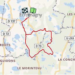
Ruta Senderismo de 6,9 km a descubrir en Borgoña-Franco Condado, Alto Saona, Écromagny. Esta ruta ha sido propuesta por tracegps.
Descripción
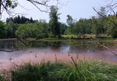
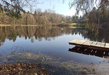
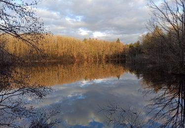
Circuit proposé par l’Office de Tourisme de la Haute Vallée de l’Ognon et de la Communauté de Communes de la Haute Vallée de l'Ognon. Départ de la place de la mairie d’Ecromagny. Retrouvez le circuit sur le site de l’Office de Tourisme de la Haute Vallée de l’Ognon. Ce circuit a été numérisé par les randonneurs du CODEPEM. Merci à Jean-Marie.
Localización
Comentarios
Excursiones cerca
![Excursión Senderismo Écromagny - Milles Étangs 18.06.2020 - Photo](https://media.geolcdn.com/t/375/260/bf565706-8d63-40d1-ae7b-2fe3d9e04a9b.jpg&format=jpg&maxdim=2)
![Senderismo Senderismo](https://static1.geolcdn.com/sitytour/trail-icons/101.png)
Senderismo
![](/images/other/stat-length.png)
![](https://static1.geolcdn.com/siteimages/upload/files/16400158638029165_repeat_loop_refresh_sync_direction_icon.png)
![Excursión Senderismo Faucogney-et-la-Mer - 08-02-20 La mer, étang de Pierre Plate et retour. - Photo](https://media.geolcdn.com/t/375/260/1db8c6b9-2ea1-4f8e-aef5-d4d9373f14e8.jpg&format=jpg&maxdim=2)
![Senderismo Senderismo](https://static1.geolcdn.com/sitytour/trail-icons/101.png)
Senderismo
![](/images/other/stat-length.png)
![](https://static1.geolcdn.com/siteimages/upload/files/16400158638029165_repeat_loop_refresh_sync_direction_icon.png)
![Excursión Bici de montaña Mélisey - 1000 2tangs 54km 935ml - Photo](https://media.geolcdn.com/t/375/260/ext.jpg?maxdim=2&url=https%3A%2F%2Fstatic1.geolcdn.com%2Fsiteimages%2Fupload%2Ffiles%2F1524743154velo.jpg)
![Bici de montaña Bici de montaña](https://static1.geolcdn.com/sitytour/trail-icons/202.png)
Bici de montaña
![](/images/other/stat-length.png)
![](https://static1.geolcdn.com/siteimages/upload/files/16400158638029165_repeat_loop_refresh_sync_direction_icon.png)
![Excursión Senderismo Écromagny - Étang de plate pierre - Photo](https://media.geolcdn.com/t/375/260/750a5518-1d11-451b-bbbc-0f0268ba730a.jpg&format=jpg&maxdim=2)
![Senderismo Senderismo](https://static1.geolcdn.com/sitytour/trail-icons/101.png)
Senderismo
![](/images/other/stat-length.png)
![](https://static1.geolcdn.com/siteimages/upload/files/16400158638029165_repeat_loop_refresh_sync_direction_icon.png)
![Excursión Senderismo Écromagny - Ecromagny Rando réelle - Photo](https://media.geolcdn.com/t/375/260/2b0a0f79-95d7-465e-83b4-b1169e1c19ae.jpg&format=jpg&maxdim=2)
![Senderismo Senderismo](https://static1.geolcdn.com/sitytour/trail-icons/101.png)
Senderismo
![](/images/other/stat-length.png)
![](https://static1.geolcdn.com/siteimages/upload/files/16400158638029165_repeat_loop_refresh_sync_direction_icon.png)
![Excursión Senderismo Belmont - 4-03-22 circuit du bois des hauts, Belmont - Photo](https://media.geolcdn.com/t/375/260/c685d17a-ab2b-45db-94e8-f03a20c0660c.jpg&format=jpg&maxdim=2)
![Senderismo Senderismo](https://static1.geolcdn.com/sitytour/trail-icons/101.png)
Senderismo
![](/images/other/stat-length.png)
![](https://static1.geolcdn.com/siteimages/upload/files/16400158638029165_repeat_loop_refresh_sync_direction_icon.png)
![Excursión Senderismo Mélisey - melissey - Photo](https://media.geolcdn.com/t/375/260/5d917a29-e862-4707-9a23-b18515e6ef08.jpg&format=jpg&maxdim=2)
![Senderismo Senderismo](https://static1.geolcdn.com/sitytour/trail-icons/101.png)
Senderismo
![](/images/other/stat-length.png)
![](https://static1.geolcdn.com/siteimages/upload/files/16400158638029165_repeat_loop_refresh_sync_direction_icon.png)
![Excursión Senderismo Faucogney-et-la-Mer - la mzr - Photo](https://media.geolcdn.com/t/375/260/4085d514-fed2-4f1a-a225-1e5c9d3a718a.jpg&format=jpg&maxdim=2)
![Senderismo Senderismo](https://static1.geolcdn.com/sitytour/trail-icons/101.png)
Senderismo
![](/images/other/stat-length.png)
![](https://static1.geolcdn.com/siteimages/upload/files/16400158638029165_repeat_loop_refresh_sync_direction_icon.png)
![Excursión Senderismo Faucogney-et-la-Mer - 23-02-22 marche Oroz, étangs... - Photo](https://media.geolcdn.com/t/375/260/65fda660-2809-43eb-960c-29389fba8610.jpg&format=jpg&maxdim=2)
![Senderismo Senderismo](https://static1.geolcdn.com/sitytour/trail-icons/101.png)
Senderismo
![](/images/other/stat-length.png)
![](https://static1.geolcdn.com/siteimages/upload/files/16400158638029165_repeat_loop_refresh_sync_direction_icon.png)