![](/images/other/stat-length.png)
![Excursión Senderismo Estissac - Entre Vanne et Forêt d'Othe - Estissac - Photo](https://media.geolcdn.com/t/1900/400/ext.pjpeg?maxdim=2&url=https%3A%2F%2Fservices.sitytrail.com%2FGeolivesWS%2FDownloadMedia.ashx%3FTrailID%3D111293%26Media%3D6935_4.jpg)
Entre Vanne et Forêt d'Othe - Estissac
tracegps
Usuario
![Longitud](/images/other/stat-length.png)
Longitud
19,5 km
![Altitud máxima](https://static1.geolcdn.com/siteimages/upload/files/1508320355ic_sort_altitude_max_24dp.png)
Altitud máxima
241 m
![Desnivel positivo](https://static1.geolcdn.com/siteimages/upload/files/1508320355ic_sort_den_pos_24dp.png)
Desnivel positivo
323 m
![Km-Effort](/images/other/stat-length.png)
Km-Effort
24 km
![Altitud mínima](https://static1.geolcdn.com/siteimages/upload/files/1508320355ic_sort_altitude_min_24dp.png)
Altitud mínima
122 m
![Desnivel negativo](https://static1.geolcdn.com/siteimages/upload/files/1508320355ic_sort_den_neg_24dp.png)
Desnivel negativo
324 m
![Boucle](https://static1.geolcdn.com/siteimages/upload/files/16400158638029165_repeat_loop_refresh_sync_direction_icon.png)
Boucle
Sí
Fecha de creación :
2014-12-10 00:00:00.0
Última modificación :
2014-12-10 00:00:00.0
![Senderismo](https://static1.geolcdn.com/sitytour/trail-icons/101.png)
5h00
Dificultad : Muy difícil
![Escanee este código QR para abrir la excursión en la aplicación SityTrail](https://capi.geolives.com/qq0zvz2zws4bq2lad0pu/sitytour/trails/111293/qr.png?size=200)
Aplicación GPS de excursión GRATIS
A propósito
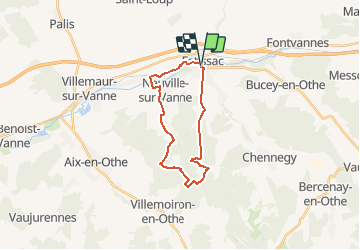
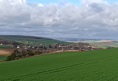
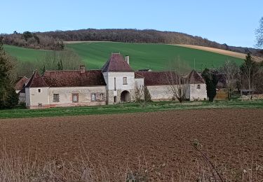
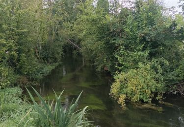
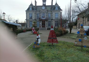
Ruta Senderismo de 19,5 km a descubrir en Gran Este, Aube, Estissac. Esta ruta ha sido propuesta por tracegps.
Descripción
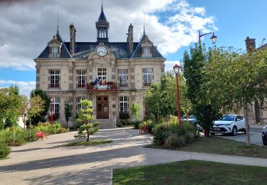
Circuit proposé par l’Office de Tourisme du Pays d’Othe. Départ de la place de la salle des fêtes d'Estissac. Retrouvez ce circuit sur le site de l’Office du Tourisme. Ce circuit a été numérisé par les randonneurs du CODEPEM. Merci à Jean-Marie.
Localización
País:
France
Región :
Gran Este
Departamento/provincia :
Aube
Municipio :
Estissac
Localidad:
Unknown
Salida:(Dec)
Salida:(UTM)
559830 ; 5346331 (31U) N.
Comentarios
Excursiones cerca
![Excursión Senderismo Bucey-en-Othe - Au dessus de BUCEY EN OTHE - Photo](https://media.geolcdn.com/t/375/260/35008645-73de-4efb-a96c-d0d684570ae0.jpg&format=jpg&maxdim=2)
![Senderismo Senderismo](https://static1.geolcdn.com/sitytour/trail-icons/101.png)
Au dessus de BUCEY EN OTHE
Senderismo
Medio
Bucey-en-Othe,
Gran Este,
Aube,
France
![](/images/other/stat-length.png)
9 km | 11,1 km-effort
2h 44min
![](https://static1.geolcdn.com/siteimages/upload/files/16400158638029165_repeat_loop_refresh_sync_direction_icon.png)
Sí
![Excursión Senderismo Bucey-en-Othe - Bucey en Othe - Photo](https://media.geolcdn.com/t/375/260/5c3adecb-99f2-402f-8840-28b9ce614624.jpg&format=jpg&maxdim=2)
![Senderismo Senderismo](https://static1.geolcdn.com/sitytour/trail-icons/101.png)
Bucey en Othe
Senderismo
Difícil
Bucey-en-Othe,
Gran Este,
Aube,
France
![](/images/other/stat-length.png)
10 km | 12,6 km-effort
3h 0min
![](https://static1.geolcdn.com/siteimages/upload/files/16400158638029165_repeat_loop_refresh_sync_direction_icon.png)
Sí
![Excursión Senderismo Chennegy - Randonnée à Chennegy - Photo](https://media.geolcdn.com/t/375/260/666caa5e-9668-4e17-9e4d-980944e36ad5.jpg&format=jpg&maxdim=2)
![Senderismo Senderismo](https://static1.geolcdn.com/sitytour/trail-icons/101.png)
Randonnée à Chennegy
Senderismo
Difícil
Chennegy,
Gran Este,
Aube,
France
![](/images/other/stat-length.png)
10,6 km | 12,4 km-effort
3h 5min
![](https://static1.geolcdn.com/siteimages/upload/files/16400158638029165_repeat_loop_refresh_sync_direction_icon.png)
Sí
![Excursión Senderismo Bucey-en-Othe - Balade autour de Bicey - Photo](https://media.geolcdn.com/t/375/260/98615ad1-cbf1-4979-baef-35b7e1343f2e.jpg&format=jpg&maxdim=2)
![Senderismo Senderismo](https://static1.geolcdn.com/sitytour/trail-icons/101.png)
Balade autour de Bicey
Senderismo
Difícil
Bucey-en-Othe,
Gran Este,
Aube,
France
![](/images/other/stat-length.png)
9,6 km | 12,5 km-effort
2h 50min
![](https://static1.geolcdn.com/siteimages/upload/files/16400158638029165_repeat_loop_refresh_sync_direction_icon.png)
Sí
![Excursión Senderismo Bucey-en-Othe - Bucey en Othe - Photo](https://media.geolcdn.com/t/375/260/3a00c592-7942-4888-b55e-9a28bdf9eb19.jpg&format=jpg&maxdim=2)
![Senderismo Senderismo](https://static1.geolcdn.com/sitytour/trail-icons/101.png)
Bucey en Othe
Senderismo
Medio
Bucey-en-Othe,
Gran Este,
Aube,
France
![](/images/other/stat-length.png)
6,7 km | 8,6 km-effort
1h 46min
![](https://static1.geolcdn.com/siteimages/upload/files/16400158638029165_repeat_loop_refresh_sync_direction_icon.png)
Sí
![Excursión Senderismo Estissac - Randonnée Bucey 01 août, 2023 - Photo](https://media.geolcdn.com/t/375/260/73372dab-7bdc-4eae-ba52-6410be568c17.jpg&format=jpg&maxdim=2)
![Senderismo Senderismo](https://static1.geolcdn.com/sitytour/trail-icons/101.png)
Randonnée Bucey 01 août, 2023
Senderismo
Medio
Estissac,
Gran Este,
Aube,
France
![](/images/other/stat-length.png)
8,3 km | 9,4 km-effort
2h 13min
![](https://static1.geolcdn.com/siteimages/upload/files/16400158638029165_repeat_loop_refresh_sync_direction_icon.png)
Sí
![Excursión Senderismo Estissac - Randonnée Club - Photo](https://media.geolcdn.com/t/375/260/3f183a86-fb71-4e1c-bc68-3aefbf52e304.jpg&format=jpg&maxdim=2)
![Senderismo Senderismo](https://static1.geolcdn.com/sitytour/trail-icons/101.png)
![Excursión Bici de carretera Estissac - EXT125 Estissac-01 - Photo](https://media.geolcdn.com/t/375/260/ac8a0968-d794-4f70-8e18-1fd419623ff1.jpg&format=jpg&maxdim=2)
![Bici de carretera Bici de carretera](https://static1.geolcdn.com/sitytour/trail-icons/201.png)
EXT125 Estissac-01
Bici de carretera
Medio
Estissac,
Gran Este,
Aube,
France
![](/images/other/stat-length.png)
126 km | 144 km-effort
6h 8min
![](https://static1.geolcdn.com/siteimages/upload/files/16400158638029165_repeat_loop_refresh_sync_direction_icon.png)
Sí
![Excursión Senderismo Bucey-en-Othe - Au dessus de Bucey et Messon - Photo](https://media.geolcdn.com/t/375/260/60700a73-91d2-41e6-ac18-57bc0b49cc95.jpg&format=jpg&maxdim=2)
![Senderismo Senderismo](https://static1.geolcdn.com/sitytour/trail-icons/101.png)
Au dessus de Bucey et Messon
Senderismo
Medio
Bucey-en-Othe,
Gran Este,
Aube,
France
![](/images/other/stat-length.png)
10,9 km | 13,5 km-effort
2h 47min
![](https://static1.geolcdn.com/siteimages/upload/files/16400158638029165_repeat_loop_refresh_sync_direction_icon.png)
Sí