![](/images/other/stat-length.png)
![Excursión Senderismo Bucey-en-Othe - La Tours des Roises - Bucey en Othe - Photo](https://media.geolcdn.com/t/1900/400/ext.pjpeg?maxdim=2&url=https%3A%2F%2Fservices.sitytrail.com%2FGeolivesWS%2FDownloadMedia.ashx%3FTrailID%3D111257%26Media%3D6846_2.jpg)
La Tours des Roises - Bucey en Othe
tracegps
Usuario
![Longitud](/images/other/stat-length.png)
Longitud
6,6 km
![Altitud máxima](https://static1.geolcdn.com/siteimages/upload/files/1508320355ic_sort_altitude_max_24dp.png)
Altitud máxima
226 m
![Desnivel positivo](https://static1.geolcdn.com/siteimages/upload/files/1508320355ic_sort_den_pos_24dp.png)
Desnivel positivo
137 m
![Km-Effort](/images/other/stat-length.png)
Km-Effort
8,4 km
![Altitud mínima](https://static1.geolcdn.com/siteimages/upload/files/1508320355ic_sort_altitude_min_24dp.png)
Altitud mínima
141 m
![Desnivel negativo](https://static1.geolcdn.com/siteimages/upload/files/1508320355ic_sort_den_neg_24dp.png)
Desnivel negativo
138 m
![Boucle](https://static1.geolcdn.com/siteimages/upload/files/16400158638029165_repeat_loop_refresh_sync_direction_icon.png)
Boucle
Sí
Fecha de creación :
2014-12-10 00:00:00.0
Última modificación :
2014-12-10 00:00:00.0
![Senderismo](https://static1.geolcdn.com/sitytour/trail-icons/101.png)
1h40
Dificultad : Medio
![Escanee este código QR para abrir la excursión en la aplicación SityTrail](https://capi.geolives.com/qq0zvz2zws4bq2lad0pu/sitytour/trails/111257/qr.png?size=200)
Aplicación GPS de excursión GRATIS
A propósito
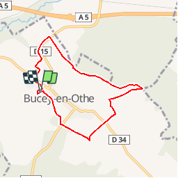
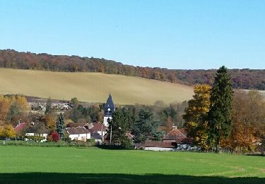
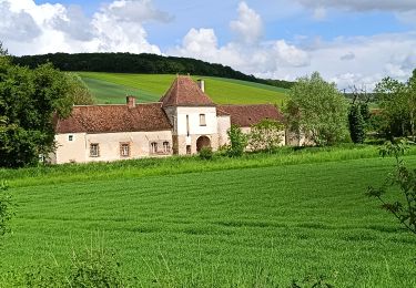
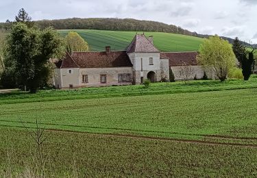
Ruta Senderismo de 6,6 km a descubrir en Gran Este, Aube, Bucey-en-Othe. Esta ruta ha sido propuesta por tracegps.
Descripción
Circuit proposé par l’Office de Tourisme du Pays d’Othe. Départ de l’église de Bucey-en-Othe. Retrouvez ce circuit sur le site de l’Office du Tourisme. Ce circuit a été numérisé par les randonneurs du CODEPEM. Merci à Jean-Marie.
Localización
País:
France
Región :
Gran Este
Departamento/provincia :
Aube
Municipio :
Bucey-en-Othe
Localidad:
Unknown
Salida:(Dec)
Salida:(UTM)
563804 ; 5345567 (31U) N.
Comentarios
Excursiones cerca
![Excursión Senderismo Chennegy - Le chemin du patrimoine du Valdreux - Photo](https://media.geolcdn.com/t/375/260/ext.jpg?maxdim=2&url=https%3A%2F%2Fservices.sitytrail.com%2FGeolivesWS%2FDownloadMedia.ashx%3FTrailID%3D487691%26Media%3Dfix__20151031115944.jpg)
![Senderismo Senderismo](https://static1.geolcdn.com/sitytour/trail-icons/101.png)
Le chemin du patrimoine du Valdreux
Senderismo
Muy fácil
(1)
Chennegy,
Gran Este,
Aube,
France
![](/images/other/stat-length.png)
8,6 km | 10,5 km-effort
1h 57min
![](https://static1.geolcdn.com/siteimages/upload/files/16400158638029165_repeat_loop_refresh_sync_direction_icon.png)
Sí
![Excursión Senderismo Vauchassis - Vauchassis Bercenay - Photo](https://media.geolcdn.com/t/375/260/3bc01075-f320-46fc-861d-82d815a161ca.jpg&format=jpg&maxdim=2)
![Senderismo Senderismo](https://static1.geolcdn.com/sitytour/trail-icons/101.png)
Vauchassis Bercenay
Senderismo
Difícil
Vauchassis,
Gran Este,
Aube,
France
![](/images/other/stat-length.png)
9,6 km | 12,3 km-effort
2h 44min
![](https://static1.geolcdn.com/siteimages/upload/files/16400158638029165_repeat_loop_refresh_sync_direction_icon.png)
Sí
![Excursión Senderismo Macey - Macey Rotarienne 2024 - Photo](https://media.geolcdn.com/t/375/260/1693199d-461d-4ebf-9a1b-95bea200eb4b.jpg&format=jpg&maxdim=2)
![Senderismo Senderismo](https://static1.geolcdn.com/sitytour/trail-icons/101.png)
Macey Rotarienne 2024
Senderismo
Medio
Macey,
Gran Este,
Aube,
France
![](/images/other/stat-length.png)
15,6 km | 19,6 km-effort
4h 50min
![](https://static1.geolcdn.com/siteimages/upload/files/16400158638029165_repeat_loop_refresh_sync_direction_icon.png)
Sí
![Excursión Senderismo Bucey-en-Othe - Au dessus de BUCEY EN OTHE - Photo](https://media.geolcdn.com/t/375/260/35008645-73de-4efb-a96c-d0d684570ae0.jpg&format=jpg&maxdim=2)
![Senderismo Senderismo](https://static1.geolcdn.com/sitytour/trail-icons/101.png)
Au dessus de BUCEY EN OTHE
Senderismo
Medio
Bucey-en-Othe,
Gran Este,
Aube,
France
![](/images/other/stat-length.png)
9 km | 11,1 km-effort
2h 44min
![](https://static1.geolcdn.com/siteimages/upload/files/16400158638029165_repeat_loop_refresh_sync_direction_icon.png)
Sí
![Excursión Senderismo Vauchassis - Randonnée Bucey 23 04 2024 - Photo](https://media.geolcdn.com/t/375/260/68155dde-7682-460a-a2d4-c9db32b7927e.jpg&format=jpg&maxdim=2)
![Senderismo Senderismo](https://static1.geolcdn.com/sitytour/trail-icons/101.png)
Randonnée Bucey 23 04 2024
Senderismo
Difícil
Vauchassis,
Gran Este,
Aube,
France
![](/images/other/stat-length.png)
10,5 km | 13,4 km-effort
3h 5min
![](https://static1.geolcdn.com/siteimages/upload/files/16400158638029165_repeat_loop_refresh_sync_direction_icon.png)
Sí
![Excursión Senderismo Bucey-en-Othe - Bucey en Othe - Photo](https://media.geolcdn.com/t/375/260/5c3adecb-99f2-402f-8840-28b9ce614624.jpg&format=jpg&maxdim=2)
![Senderismo Senderismo](https://static1.geolcdn.com/sitytour/trail-icons/101.png)
Bucey en Othe
Senderismo
Difícil
Bucey-en-Othe,
Gran Este,
Aube,
France
![](/images/other/stat-length.png)
10 km | 12,6 km-effort
3h 0min
![](https://static1.geolcdn.com/siteimages/upload/files/16400158638029165_repeat_loop_refresh_sync_direction_icon.png)
Sí
![Excursión Senderismo Vauchassis - Balade Forêt communale de Vauchassis - Photo](https://media.geolcdn.com/t/375/260/60154d9b-5182-45e8-96d5-ba2683475c3b.jpg&format=jpg&maxdim=2)
![Senderismo Senderismo](https://static1.geolcdn.com/sitytour/trail-icons/101.png)
Balade Forêt communale de Vauchassis
Senderismo
Medio
Vauchassis,
Gran Este,
Aube,
France
![](/images/other/stat-length.png)
7,5 km | 9,1 km-effort
2h 26min
![](https://static1.geolcdn.com/siteimages/upload/files/16400158638029165_repeat_loop_refresh_sync_direction_icon.png)
Sí
![Excursión Senderismo Vauchassis - Vauchassis Bercenay Vauchassis - Photo](https://media.geolcdn.com/t/375/260/47a3c001-c9e0-442d-bf86-fe83ec300e69.jpg&format=jpg&maxdim=2)
![Senderismo Senderismo](https://static1.geolcdn.com/sitytour/trail-icons/101.png)
Vauchassis Bercenay Vauchassis
Senderismo
Difícil
Vauchassis,
Gran Este,
Aube,
France
![](/images/other/stat-length.png)
10,3 km | 13 km-effort
3h 2min
![](https://static1.geolcdn.com/siteimages/upload/files/16400158638029165_repeat_loop_refresh_sync_direction_icon.png)
Sí
![Excursión Senderismo Vauchassis - Randonnée Grands Bois Vauchassis - Photo](https://media.geolcdn.com/t/375/260/9d027c1e-e535-409f-87d7-d0acadfbd13f.jpg&format=jpg&maxdim=2)
![Senderismo Senderismo](https://static1.geolcdn.com/sitytour/trail-icons/101.png)
Randonnée Grands Bois Vauchassis
Senderismo
Medio
Vauchassis,
Gran Este,
Aube,
France
![](/images/other/stat-length.png)
9,7 km | 12 km-effort
2h 51min
![](https://static1.geolcdn.com/siteimages/upload/files/16400158638029165_repeat_loop_refresh_sync_direction_icon.png)
Sí