![](/images/other/stat-length.png)
![Excursión Senderismo La Goulafrière - Circuit de la Grande Vallée - La Goulafrière - Photo](https://media.geolcdn.com/t/1900/400/ext.pjpeg?maxdim=2&url=https%3A%2F%2Fservices.sitytrail.com%2FGeolivesWS%2FDownloadMedia.ashx%3FTrailID%3D110461%26Media%3D5968_1.jpg)
Circuit de la Grande Vallée - La Goulafrière
tracegps
Usuario
![Longitud](/images/other/stat-length.png)
Longitud
11,2 km
![Altitud máxima](https://static1.geolcdn.com/siteimages/upload/files/1508320355ic_sort_altitude_max_24dp.png)
Altitud máxima
205 m
![Desnivel positivo](https://static1.geolcdn.com/siteimages/upload/files/1508320355ic_sort_den_pos_24dp.png)
Desnivel positivo
144 m
![Km-Effort](/images/other/stat-length.png)
Km-Effort
13,1 km
![Altitud mínima](https://static1.geolcdn.com/siteimages/upload/files/1508320355ic_sort_altitude_min_24dp.png)
Altitud mínima
145 m
![Desnivel negativo](https://static1.geolcdn.com/siteimages/upload/files/1508320355ic_sort_den_neg_24dp.png)
Desnivel negativo
144 m
![Boucle](https://static1.geolcdn.com/siteimages/upload/files/16400158638029165_repeat_loop_refresh_sync_direction_icon.png)
Boucle
Sí
Fecha de creación :
2014-12-10 00:00:00.0
Última modificación :
2014-12-10 00:00:00.0
![Senderismo](https://static1.geolcdn.com/sitytour/trail-icons/101.png)
2h45
Dificultad : Medio
![Escanee este código QR para abrir la excursión en la aplicación SityTrail](https://capi.geolives.com/qq0zvz2zws4bq2lad0pu/sitytour/trails/110461/qr.png?size=200)
Aplicación GPS de excursión GRATIS
A propósito
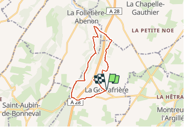
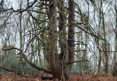
Ruta Senderismo de 11,2 km a descubrir en Normandía, Eure, La Goulafrière. Esta ruta ha sido propuesta por tracegps.
Descripción
Circuit proposé par la Communauté de Communes du canton de Broglie. Départ de la mairie de La Goulafrière. Ce circuit a été numérisé par les randonneurs du CODEPEM. Merci à Jean-Marie.
Localización
País:
France
Región :
Normandía
Departamento/provincia :
Eure
Municipio :
La Goulafrière
Localidad:
Unknown
Salida:(Dec)
Salida:(UTM)
312310 ; 5425045 (31U) N.
Comentarios
Excursiones cerca
![Excursión Senderismo La Chapelle-Gauthier - La Mare Péreuse - La Chapelle-Gauthier - Photo](https://media.geolcdn.com/t/375/260/ext.jpg?maxdim=2&url=https%3A%2F%2Fservices.sitytrail.com%2FGeolivesWS%2FDownloadMedia.ashx%3FTrailID%3D110446%26Media%3D5936_3.jpg)
![Senderismo Senderismo](https://static1.geolcdn.com/sitytour/trail-icons/101.png)
La Mare Péreuse - La Chapelle-Gauthier
Senderismo
Medio
La Chapelle-Gauthier,
Normandía,
Eure,
France
![](/images/other/stat-length.png)
10,3 km | 11,9 km-effort
2h 45min
![](https://static1.geolcdn.com/siteimages/upload/files/16400158638029165_repeat_loop_refresh_sync_direction_icon.png)
Sí
![Excursión Senderismo Montreuil-l'Argillé - autour de Montreuil l argilleé - Photo](https://media.geolcdn.com/t/375/260/38c38167-b310-406a-995f-a8d9a500d0cd.jpg&format=jpg&maxdim=2)
![Senderismo Senderismo](https://static1.geolcdn.com/sitytour/trail-icons/101.png)
autour de Montreuil l argilleé
Senderismo
Muy fácil
Montreuil-l'Argillé,
Normandía,
Eure,
France
![](/images/other/stat-length.png)
5,3 km | 6,2 km-effort
1h 11min
![](https://static1.geolcdn.com/siteimages/upload/files/16400158638029165_repeat_loop_refresh_sync_direction_icon.png)
Sí
![Excursión Bicicleta Montreuil-l'Argillé - Boucle des mottes féodales - Montreuil-l'Argillé - Photo](https://media.geolcdn.com/t/375/260/ext.jpg?maxdim=2&url=https%3A%2F%2Fservices.sitytrail.com%2FGeolivesWS%2FDownloadMedia.ashx%3FTrailID%3D110415%26Media%3D5889_1.jpg)
![Bicicleta Bicicleta](https://static1.geolcdn.com/sitytour/trail-icons/200.png)
Boucle des mottes féodales - Montreuil-l'Argillé
Bicicleta
Difícil
Montreuil-l'Argillé,
Normandía,
Eure,
France
![](/images/other/stat-length.png)
24 km | 27 km-effort
1h 30min
![](https://static1.geolcdn.com/siteimages/upload/files/16400158638029165_repeat_loop_refresh_sync_direction_icon.png)
Sí
![Excursión Senderismo La Folletière-Abenon - Source de l'Orbiquet avec Cressonnière - Photo](https://media.geolcdn.com/t/375/260/ext.jpg?maxdim=2&url=https%3A%2F%2Fstatic1.geolcdn.com%2Fsiteimages%2Fupload%2Ffiles%2F1553511878bg_sport_marche.png)
![Senderismo Senderismo](https://static1.geolcdn.com/sitytour/trail-icons/101.png)
Source de l'Orbiquet avec Cressonnière
Senderismo
Fácil
La Folletière-Abenon,
Normandía,
Calvados,
France
![](/images/other/stat-length.png)
14,1 km | 17,5 km-effort
3h 58min
![](https://static1.geolcdn.com/siteimages/upload/files/16400158638029165_repeat_loop_refresh_sync_direction_icon.png)
Sí
![Excursión Senderismo Montreuil-l'Argillé - Montreuil L'Argillė - Photo](https://media.geolcdn.com/t/375/260/ext.jpg?maxdim=2&url=https%3A%2F%2Fstatic1.geolcdn.com%2Fsiteimages%2Fupload%2Ffiles%2F1553511878bg_sport_marche.png)
![Senderismo Senderismo](https://static1.geolcdn.com/sitytour/trail-icons/101.png)
Montreuil L'Argillė
Senderismo
Medio
Montreuil-l'Argillé,
Normandía,
Eure,
France
![](/images/other/stat-length.png)
9,2 km | 10,8 km-effort
2h 20min
![](https://static1.geolcdn.com/siteimages/upload/files/16400158638029165_repeat_loop_refresh_sync_direction_icon.png)
Sí
![Excursión A pie La Folletière-Abenon - Les Sources de l'Orbiquet - Photo](https://media.geolcdn.com/t/375/260/ext.jpg?maxdim=2&url=https%3A%2F%2Fstatic1.geolcdn.com%2Fsiteimages%2Fupload%2Ffiles%2F1545311037marcheuse_200dpi.jpg)
![A pie A pie](https://static1.geolcdn.com/sitytour/trail-icons/100.png)
Les Sources de l'Orbiquet
A pie
Fácil
La Folletière-Abenon,
Normandía,
Calvados,
France
![](/images/other/stat-length.png)
3,7 km | 4,4 km-effort
59min
![](https://static1.geolcdn.com/siteimages/upload/files/16400158638029165_repeat_loop_refresh_sync_direction_icon.png)
No
![Excursión Senderismo La Folletière-Abenon - la folletière abenon - Photo](https://media.geolcdn.com/t/375/260/ext.jpg?maxdim=2&url=https%3A%2F%2Fstatic1.geolcdn.com%2Fsiteimages%2Fupload%2Ffiles%2F1553511878bg_sport_marche.png)
![Senderismo Senderismo](https://static1.geolcdn.com/sitytour/trail-icons/101.png)
la folletière abenon
Senderismo
Medio
La Folletière-Abenon,
Normandía,
Calvados,
France
![](/images/other/stat-length.png)
12,1 km | 14,6 km-effort
3h 17min
![](https://static1.geolcdn.com/siteimages/upload/files/16400158638029165_repeat_loop_refresh_sync_direction_icon.png)
Sí
![Excursión Senderismo La Folletière-Abenon - la folletière abenon - Photo](https://media.geolcdn.com/t/375/260/ext.jpg?maxdim=2&url=https%3A%2F%2Fstatic1.geolcdn.com%2Fsiteimages%2Fupload%2Ffiles%2F1553511878bg_sport_marche.png)
![Senderismo Senderismo](https://static1.geolcdn.com/sitytour/trail-icons/101.png)
la folletière abenon
Senderismo
Fácil
La Folletière-Abenon,
Normandía,
Calvados,
France
![](/images/other/stat-length.png)
36 km | 42 km-effort
4h 25min
![](https://static1.geolcdn.com/siteimages/upload/files/16400158638029165_repeat_loop_refresh_sync_direction_icon.png)
No
![Excursión Senderismo La Goulafrière - La Goulafriere 27 - Photo](https://media.geolcdn.com/t/375/260/57bcf86c-5668-45d7-9473-13e9f837b6a9.jpg&format=jpg&maxdim=2)
![Senderismo Senderismo](https://static1.geolcdn.com/sitytour/trail-icons/101.png)
La Goulafriere 27
Senderismo
Fácil
La Goulafrière,
Normandía,
Eure,
France
![](/images/other/stat-length.png)
11,9 km | 13,9 km-effort
3h 8min
![](https://static1.geolcdn.com/siteimages/upload/files/16400158638029165_repeat_loop_refresh_sync_direction_icon.png)
Sí