![](/images/other/stat-length.png)
![Excursión Bici de montaña Benoîtville - De Benoîtville à Saint Christophe du Foc - Circuit n° 12 - Photo](https://media.geolcdn.com/t/1900/400/ext.pjpeg?maxdim=2&url=https%3A%2F%2Fservices.sitytrail.com%2FGeolivesWS%2FDownloadMedia.ashx%3FTrailID%3D110389%26Media%3D5846_1.jpg)
De Benoîtville à Saint Christophe du Foc - Circuit n° 12
tracegps
Usuario
![Longitud](/images/other/stat-length.png)
![Altitud máxima](https://static1.geolcdn.com/siteimages/upload/files/1508320355ic_sort_altitude_max_24dp.png)
![Desnivel positivo](https://static1.geolcdn.com/siteimages/upload/files/1508320355ic_sort_den_pos_24dp.png)
![Km-Effort](/images/other/stat-length.png)
![Altitud mínima](https://static1.geolcdn.com/siteimages/upload/files/1508320355ic_sort_altitude_min_24dp.png)
![Desnivel negativo](https://static1.geolcdn.com/siteimages/upload/files/1508320355ic_sort_den_neg_24dp.png)
![Boucle](https://static1.geolcdn.com/siteimages/upload/files/16400158638029165_repeat_loop_refresh_sync_direction_icon.png)
![Bici de montaña](https://static1.geolcdn.com/sitytour/trail-icons/202.png)
1h45
Dificultad : Medio
![Escanee este código QR para abrir la excursión en la aplicación SityTrail](https://capi.geolives.com/qq0zvz2zws4bq2lad0pu/sitytour/trails/110389/qr.png?size=200)
Aplicación GPS de excursión GRATIS
A propósito
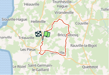
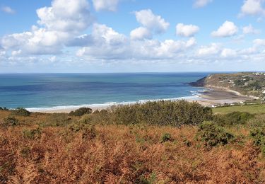
Ruta Bici de montaña de 21 km a descubrir en Normandía, Mancha, Benoîtville. Esta ruta ha sido propuesta por tracegps.
Descripción
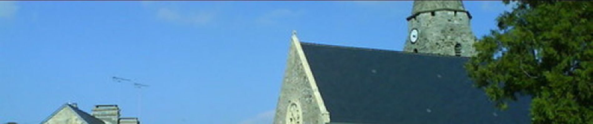
Départ : Bourg de Benoîtville Église paroissiale Saint-Martin. Datant du XIIIème siècle, elle comporte un curieux clocher avec une tour carrée et une flèche à huit pans qui porte à sa base l’inscription « Sainte Barbe priez pour nous ». La nef de l’église fût restaurée en 1870. A l’intérieur on peut y voir, une perche datant du XII-XIIIème, un petit Saint Fiacre et de chaque côté de l’autel une très belle Vierge à l’enfant. Château de Sotteville. Construit entre 1593 et 1610, il aurait une origine plus ancienne. Il ne subsiste cependant plus aucun renseignement concernant ses fondations qui remonteraient au Haut Moyen-Age. SAINT CHRISTOPHE DU FOC : Manoir de la Barguignerie. Il fut sans doute construit à deux époques différentes. La partie gauche évoque le style renaissance, contrairement à l’aile droite de ce bâtiment, de structure plus simple (1645). La façade du milieu du XVIIème succède à l’aile renaissance qui comporte une petite tourelle coiffée d’un toit en poivrière. Un petit escalier mène à la porte principale, elle-même entourée de très élégantes colonnes. Il est à noter sur la partie la plus récente, la présence de deux écussons : celui des Le Filastre, et celui des Ravalets qui surmonte une porte. Église de Grosville. Elle date de la deuxième moitié du XIIIème siècle et possède une nef unique : les chapelles formant un transept et un très joli chœur à fenêtres rayonnantes. La tour carrée est à flèche octogonale. Elle possède également des statues XVème. « Éducation de la Vierge » XIVème (Sainte Anne et la Vierge en pierre calcaire polychrome, œuvre anciennement datée de la fin du XVIème, ou début XVème). « Crucifixion » XVIIIème. On trouve au cimetière la sépulture de l’abbé Mabire, plus connu comme ayant été le chapelin de Louis XVI. Manoir des Tourelles. C’est une des curiosités de Grosville, inscrit à l’Inventaire des Monuments historiques depuis 1975. Façades et toitures des 3 pavillons XVII / XVIIIème, plafond à la française. Trois tourelles carrées sont coiffés de beaux épis de faîtages en poterie de Saint Jacques de Néhou ou de Sauxemesnil.
Localización
Comentarios
Excursiones cerca
![Excursión Senderismo Les Pieux - Entre terre et mer - Les Pieux - Photo](https://media.geolcdn.com/t/375/260/ext.jpg?maxdim=2&url=https%3A%2F%2Fservices.sitytrail.com%2FGeolivesWS%2FDownloadMedia.ashx%3FTrailID%3D173114%26Media%3D14665_6.jpg)
![Senderismo Senderismo](https://static1.geolcdn.com/sitytour/trail-icons/101.png)
Senderismo
![](/images/other/stat-length.png)
![](https://static1.geolcdn.com/siteimages/upload/files/16400158638029165_repeat_loop_refresh_sync_direction_icon.png)
![Excursión Senderismo Les Pieux - Séjour Cotentin Etape 5 Les Pieux - Barneville - Photo](https://media.geolcdn.com/t/375/260/ccdd36f2-a9ba-4c0c-9e04-9fc802c2ab0c.jpg&format=jpg&maxdim=2)
![Senderismo Senderismo](https://static1.geolcdn.com/sitytour/trail-icons/101.png)
Senderismo
![](/images/other/stat-length.png)
![](https://static1.geolcdn.com/siteimages/upload/files/16400158638029165_repeat_loop_refresh_sync_direction_icon.png)
![Excursión Carrera Les Pieux - Entre terre et mer - Les Pieux - Photo](https://media.geolcdn.com/t/375/260/ext.jpg?maxdim=2&url=https%3A%2F%2Fservices.sitytrail.com%2FGeolivesWS%2FDownloadMedia.ashx%3FTrailID%3D173115%26Media%3D14665_6.jpg)
![Carrera Carrera](https://static1.geolcdn.com/sitytour/trail-icons/103.png)
Carrera
![](/images/other/stat-length.png)
![](https://static1.geolcdn.com/siteimages/upload/files/16400158638029165_repeat_loop_refresh_sync_direction_icon.png)
![Excursión Senderismo Le Rozel - Le Rozel - Cap de Rozel - Photo](https://media.geolcdn.com/t/375/260/17f16fb5-4314-4722-bdde-11b6422eaa01.jpg&format=jpg&maxdim=2)
![Senderismo Senderismo](https://static1.geolcdn.com/sitytour/trail-icons/101.png)
Senderismo
![](/images/other/stat-length.png)
![](https://static1.geolcdn.com/siteimages/upload/files/16400158638029165_repeat_loop_refresh_sync_direction_icon.png)
![Excursión Senderismo Les Pieux - Les Pieux, Le Rozel, Flamanville - Photo](https://media.geolcdn.com/t/375/260/de1683a4-2ee2-4c07-a12a-146098a9e135.jpg&format=jpg&maxdim=2)
![Senderismo Senderismo](https://static1.geolcdn.com/sitytour/trail-icons/101.png)
Senderismo
![](/images/other/stat-length.png)
![](https://static1.geolcdn.com/siteimages/upload/files/16400158638029165_repeat_loop_refresh_sync_direction_icon.png)
![Excursión Bici de montaña Bricquebosq - People are strange track - MTB from Bricquebosc - Photo](https://media.geolcdn.com/t/375/260/ext.jpg?maxdim=2&url=https%3A%2F%2Fservices.sitytrail.com%2FGeolivesWS%2FDownloadMedia.ashx%3FTrailID%3D107481%26Media%3D12425_1.jpg)
![Bici de montaña Bici de montaña](https://static1.geolcdn.com/sitytour/trail-icons/202.png)
Bici de montaña
![](/images/other/stat-length.png)
![](https://static1.geolcdn.com/siteimages/upload/files/16400158638029165_repeat_loop_refresh_sync_direction_icon.png)
![Excursión Senderismo Saint-Christophe-du-Foc - St christophecdu foc - Photo](https://media.geolcdn.com/t/375/260/ext.jpg?maxdim=2&url=https%3A%2F%2Fstatic1.geolcdn.com%2Fsiteimages%2Fupload%2Ffiles%2F1553511878bg_sport_marche.png)
![Senderismo Senderismo](https://static1.geolcdn.com/sitytour/trail-icons/101.png)
Senderismo
![](/images/other/stat-length.png)
![](https://static1.geolcdn.com/siteimages/upload/files/16400158638029165_repeat_loop_refresh_sync_direction_icon.png)
![Excursión Senderismo Siouville-Hague - siouville - biville - siouville - Photo](https://media.geolcdn.com/t/375/260/ext.jpg?maxdim=2&url=https%3A%2F%2Fstatic1.geolcdn.com%2Fsiteimages%2Fupload%2Ffiles%2F1553511878bg_sport_marche.png)
![Senderismo Senderismo](https://static1.geolcdn.com/sitytour/trail-icons/101.png)
Senderismo
![](/images/other/stat-length.png)
![](https://static1.geolcdn.com/siteimages/upload/files/16400158638029165_repeat_loop_refresh_sync_direction_icon.png)
![Excursión Senderismo Siouville-Hague - Goury-Port Racine - Photo](https://media.geolcdn.com/t/375/260/ext.jpg?maxdim=2&url=https%3A%2F%2Fstatic1.geolcdn.com%2Fsiteimages%2Fupload%2Ffiles%2F1553511878bg_sport_marche.png)
![Senderismo Senderismo](https://static1.geolcdn.com/sitytour/trail-icons/101.png)
Senderismo
![](/images/other/stat-length.png)
![](https://static1.geolcdn.com/siteimages/upload/files/16400158638029165_repeat_loop_refresh_sync_direction_icon.png)
Excellent