![](/images/other/stat-length.png)
![Excursión Senderismo Saint-Jacques-en-Valgodemard - Tour du Vieux Chaillol 1/5 - Gite Les Paris au Gite Le Casset - Photo](https://media.geolcdn.com/t/1900/400/ext.pjpeg?maxdim=2&url=https%3A%2F%2Fservices.sitytrail.com%2FGeolivesWS%2FDownloadMedia.ashx%3FTrailID%3D110177%26Media%3D5385_2.jpg)
Tour du Vieux Chaillol 1/5 - Gite Les Paris au Gite Le Casset
tracegps
Usuario
![Longitud](/images/other/stat-length.png)
![Altitud máxima](https://static1.geolcdn.com/siteimages/upload/files/1508320355ic_sort_altitude_max_24dp.png)
![Desnivel positivo](https://static1.geolcdn.com/siteimages/upload/files/1508320355ic_sort_den_pos_24dp.png)
![Km-Effort](/images/other/stat-length.png)
![Altitud mínima](https://static1.geolcdn.com/siteimages/upload/files/1508320355ic_sort_altitude_min_24dp.png)
![Desnivel negativo](https://static1.geolcdn.com/siteimages/upload/files/1508320355ic_sort_den_neg_24dp.png)
![Boucle](https://static1.geolcdn.com/siteimages/upload/files/16400158638029165_repeat_loop_refresh_sync_direction_icon.png)
![Senderismo](https://static1.geolcdn.com/sitytour/trail-icons/101.png)
6h30
Dificultad : Medio
![Escanee este código QR para abrir la excursión en la aplicación SityTrail](https://capi.geolives.com/qq0zvz2zws4bq2lad0pu/sitytour/trails/110177/qr.png?size=200)
Aplicación GPS de excursión GRATIS
A propósito
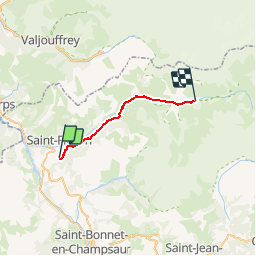
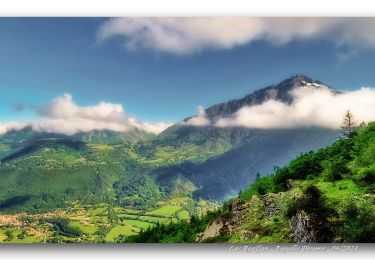
Ruta Senderismo de 20 km a descubrir en Provenza-Alpes-Costa Azul, Altos Alpes, Saint-Jacques-en-Valgodemard. Esta ruta ha sido propuesta por tracegps.
Descripción
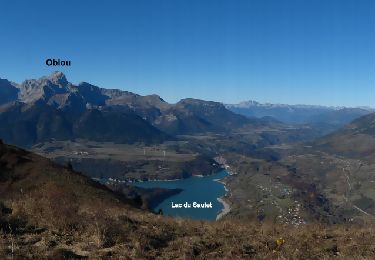
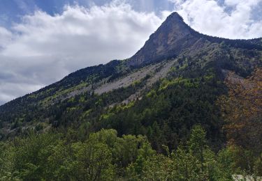
Première étape du Gite d’étape « Les Paris » au Gite du Casset. Nous vous proposons un itinéraire préservé et varié, reliant la vallée du Valgaudemar aux paysages de bocage de montagne du Champsaur. Au cœur du Parc National des Ecrins, vous découvrirez la richesse de la faune et de la flore, chamois, marmottes, aigles, lys orangés... Vous serez accueillis en gîte d'étape et en refuge où vous trouverez confort, authenticité, convivialité. Renseignements et réservations centralisés au 04 92 55 30 07 Le portage des sacs : Vos bagages peuvent être transportés dans la journée pour les retrouver le soir dans chaque gîte (sauf refuge). Possibilité de circuit avec un accompagnateur. Possibilité de portage des bagages avec des ânes.
Localización
Comentarios
Excursiones cerca
![Excursión Senderismo Aspres-lès-Corps - Aspres les corps - Roche Courbe - Photo](https://media.geolcdn.com/t/375/260/ext.jpg?maxdim=2&url=https%3A%2F%2Fservices.sitytrail.com%2FGeolivesWS%2FDownloadMedia.ashx%3FTrailID%3D655638%26Media%3Dd468d5e8-71c8-44e5-98f2-217554c35ba5.JPG)
![Senderismo Senderismo](https://static1.geolcdn.com/sitytour/trail-icons/101.png)
Senderismo
![](/images/other/stat-length.png)
![](https://static1.geolcdn.com/siteimages/upload/files/16400158638029165_repeat_loop_refresh_sync_direction_icon.png)
![Excursión Esquí de fondo Aspres-lès-Corps - tentative du Laton, pic gazonné - Photo](https://media.geolcdn.com/t/375/260/bb214dca-e6e7-4564-b147-bec3a550b510.jpg&format=jpg&maxdim=2)
![Esquí de fondo Esquí de fondo](https://static1.geolcdn.com/sitytour/trail-icons/503.png)
Esquí de fondo
![](/images/other/stat-length.png)
![](https://static1.geolcdn.com/siteimages/upload/files/16400158638029165_repeat_loop_refresh_sync_direction_icon.png)
![Excursión Senderismo Saint-Firmin - YHH081 Vallon de Prentiq - Photo](https://media.geolcdn.com/t/375/260/ext.jpg?maxdim=2&url=https%3A%2F%2Fstatic1.geolcdn.com%2Fsiteimages%2Fupload%2Ffiles%2F1553511878bg_sport_marche.png)
![Senderismo Senderismo](https://static1.geolcdn.com/sitytour/trail-icons/101.png)
Senderismo
![](/images/other/stat-length.png)
![](https://static1.geolcdn.com/siteimages/upload/files/16400158638029165_repeat_loop_refresh_sync_direction_icon.png)
![Excursión Senderismo Aubessagne - Aiguille_Péoume_Via_Lac_Roaffan - Photo](https://media.geolcdn.com/t/375/260/4f886363-c9aa-4398-ba00-b9eb10a848b9.jpg&format=jpg&maxdim=2)
![Senderismo Senderismo](https://static1.geolcdn.com/sitytour/trail-icons/101.png)
Senderismo
![](/images/other/stat-length.png)
![](https://static1.geolcdn.com/siteimages/upload/files/16400158638029165_repeat_loop_refresh_sync_direction_icon.png)
![Excursión Senderismo Aspres-lès-Corps - Roche Courbe en circuit - Photo](https://media.geolcdn.com/t/375/260/d98dbc92-c0e3-4883-814f-4596e6fce13d.jpg&format=jpg&maxdim=2)
![Senderismo Senderismo](https://static1.geolcdn.com/sitytour/trail-icons/101.png)
Senderismo
![](/images/other/stat-length.png)
![](https://static1.geolcdn.com/siteimages/upload/files/16400158638029165_repeat_loop_refresh_sync_direction_icon.png)
![Excursión Senderismo Saint-Firmin - Les pres hauts 6 kms - Photo](https://media.geolcdn.com/t/375/260/acf69bfd-b45f-4a67-8613-3852a16cd78f.jpg&format=jpg&maxdim=2)
![Senderismo Senderismo](https://static1.geolcdn.com/sitytour/trail-icons/101.png)
Senderismo
![](/images/other/stat-length.png)
![](https://static1.geolcdn.com/siteimages/upload/files/16400158638029165_repeat_loop_refresh_sync_direction_icon.png)
![Excursión Senderismo Le Glaizil - 20190528_Chapeau de l'évêque via Le Glaizil - Photo](https://media.geolcdn.com/t/375/260/ea70badd-d667-47d7-be30-49da918fa297.jpg&format=jpg&maxdim=2)
![Senderismo Senderismo](https://static1.geolcdn.com/sitytour/trail-icons/101.png)
Senderismo
![](/images/other/stat-length.png)
![](https://static1.geolcdn.com/siteimages/upload/files/16400158638029165_repeat_loop_refresh_sync_direction_icon.png)
![Excursión Senderismo Saint-Jacques-en-Valgodemard - 20190409_Lac de Roaffan - Photo](https://media.geolcdn.com/t/375/260/9022de43-54f4-44a8-9678-8541607672ee.jpg&format=jpg&maxdim=2)
![Senderismo Senderismo](https://static1.geolcdn.com/sitytour/trail-icons/101.png)
Senderismo
![](/images/other/stat-length.png)
![](https://static1.geolcdn.com/siteimages/upload/files/16400158638029165_repeat_loop_refresh_sync_direction_icon.png)
![Excursión Senderismo Le Glaizil - Chapeau de l'évêque via le Glaizil - Photo](https://media.geolcdn.com/t/375/260/4547cba4-2d7b-4a86-be10-1613c25f7722.jpg&format=jpg&maxdim=2)
![Senderismo Senderismo](https://static1.geolcdn.com/sitytour/trail-icons/101.png)
Senderismo
![](/images/other/stat-length.png)
![](https://static1.geolcdn.com/siteimages/upload/files/16400158638029165_repeat_loop_refresh_sync_direction_icon.png)
Débutant mais je l'ai fais avec sac de 20kilos ;) Hard quand même.