![](/images/other/stat-length.png)
![Excursión Senderismo Le Hohwald - Du Hohwald au Champ du Feu - Photo](https://media.geolcdn.com/t/1900/400/ext.pjpeg?maxdim=2&url=https%3A%2F%2Fservices.sitytrail.com%2FGeolivesWS%2FDownloadMedia.ashx%3FTrailID%3D109958%26Media%3D5025_1.jpg)
Du Hohwald au Champ du Feu
tracegps
Usuario
![Longitud](/images/other/stat-length.png)
![Altitud máxima](https://static1.geolcdn.com/siteimages/upload/files/1508320355ic_sort_altitude_max_24dp.png)
![Desnivel positivo](https://static1.geolcdn.com/siteimages/upload/files/1508320355ic_sort_den_pos_24dp.png)
![Km-Effort](/images/other/stat-length.png)
![Altitud mínima](https://static1.geolcdn.com/siteimages/upload/files/1508320355ic_sort_altitude_min_24dp.png)
![Desnivel negativo](https://static1.geolcdn.com/siteimages/upload/files/1508320355ic_sort_den_neg_24dp.png)
![Boucle](https://static1.geolcdn.com/siteimages/upload/files/16400158638029165_repeat_loop_refresh_sync_direction_icon.png)
![Senderismo](https://static1.geolcdn.com/sitytour/trail-icons/101.png)
6h00
Dificultad : Muy difícil
![Escanee este código QR para abrir la excursión en la aplicación SityTrail](https://capi.geolives.com/qq0zvz2zws4bq2lad0pu/sitytour/trails/109958/qr.png?size=200)
Aplicación GPS de excursión GRATIS
A propósito
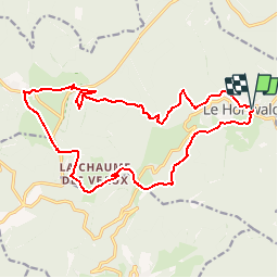
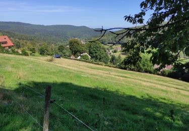
Ruta Senderismo de 17,8 km a descubrir en Gran Este, Bajo-Rin, Le Hohwald. Esta ruta ha sido propuesta por tracegps.
Descripción
Du Hohwald au Champ du Feu. Des forêts du Hohwald aux chaumes du Champ de Feu en passant par la cascade de l’Andlau. Pour toute information complémentaire sur la randonnée : Comité départemental du Bas Rhin: 9 RUE MEYER 67500 HAGUENAU Tél. : 0388907606
Localización
Comentarios
Excursiones cerca
![Excursión Paseo ecuestre Ottrott - 2024-09-03_17h19m14_suuntoapp-HorsebackRiding-2024-09-03T08-25-34Z-track - Photo](https://media.geolcdn.com/t/375/260/83371a81-1c5b-4988-84fb-7fd3471a6a57.jpg&format=jpg&maxdim=2)
![Paseo ecuestre Paseo ecuestre](https://static1.geolcdn.com/sitytour/trail-icons/301.png)
Paseo ecuestre
![](/images/other/stat-length.png)
![](https://static1.geolcdn.com/siteimages/upload/files/16400158638029165_repeat_loop_refresh_sync_direction_icon.png)
![Excursión Senderismo Le Hohwald - suuntoapp-Hiking-2024-04-27T09-12-29Z - Photo](https://media.geolcdn.com/t/375/260/d8b206f8-0969-498e-bcc6-fd799e0e40cd.jpg&format=jpg&maxdim=2)
![Senderismo Senderismo](https://static1.geolcdn.com/sitytour/trail-icons/101.png)
Senderismo
![](/images/other/stat-length.png)
![](https://static1.geolcdn.com/siteimages/upload/files/16400158638029165_repeat_loop_refresh_sync_direction_icon.png)
![Excursión Senderismo Reichsfeld - 2019-12-28 Marche Reichsfeld Ungersberg Gruckert - Photo](https://media.geolcdn.com/t/375/260/42eae20f-c3f4-4c06-9edb-b597f2c7a1bb.jpg&format=jpg&maxdim=2)
![Senderismo Senderismo](https://static1.geolcdn.com/sitytour/trail-icons/101.png)
Senderismo
![](/images/other/stat-length.png)
![](https://static1.geolcdn.com/siteimages/upload/files/16400158638029165_repeat_loop_refresh_sync_direction_icon.png)
![Excursión Senderismo Le Hohwald - Tour du Hohwald - Photo](https://media.geolcdn.com/t/375/260/ext.jpg?maxdim=2&url=https%3A%2F%2Fstatic1.geolcdn.com%2Fsiteimages%2Fupload%2Ffiles%2F1553511878bg_sport_marche.png)
![Senderismo Senderismo](https://static1.geolcdn.com/sitytour/trail-icons/101.png)
Senderismo
![](/images/other/stat-length.png)
![](https://static1.geolcdn.com/siteimages/upload/files/16400158638029165_repeat_loop_refresh_sync_direction_icon.png)
![Excursión Senderismo Ottrott - 2013-12-29 Marche Mt Ste Odile Maennelstein Birkenfels - Photo](https://media.geolcdn.com/t/375/260/ext.jpg?maxdim=2&url=https%3A%2F%2Fstatic1.geolcdn.com%2Fsiteimages%2Fupload%2Ffiles%2F1553511878bg_sport_marche.png)
![Senderismo Senderismo](https://static1.geolcdn.com/sitytour/trail-icons/101.png)
Senderismo
![](/images/other/stat-length.png)
![](https://static1.geolcdn.com/siteimages/upload/files/16400158638029165_repeat_loop_refresh_sync_direction_icon.png)
![Excursión Senderismo Le Hohwald - Hohwald - Rothlach - Neuntelstein - Photo](https://media.geolcdn.com/t/375/260/0ea7410a-d32d-4905-9369-a48f058188e6.jpg&format=jpg&maxdim=2)
![Senderismo Senderismo](https://static1.geolcdn.com/sitytour/trail-icons/101.png)
Senderismo
![](/images/other/stat-length.png)
![](https://static1.geolcdn.com/siteimages/upload/files/16400158638029165_repeat_loop_refresh_sync_direction_icon.png)
![Excursión A pie Le Hohwald - Champ du feu début - Photo](https://media.geolcdn.com/t/375/260/f322735a-2e98-4355-b067-4845daa855de.jpg&format=jpg&maxdim=2)
![A pie A pie](https://static1.geolcdn.com/sitytour/trail-icons/100.png)
A pie
![](/images/other/stat-length.png)
![](https://static1.geolcdn.com/siteimages/upload/files/16400158638029165_repeat_loop_refresh_sync_direction_icon.png)
![Excursión Senderismo Le Hohwald - le hohwald, boucle](https://media.geolcdn.com/t/375/260/cc43b1d5-9e0d-477b-9cf7-84cc19342b6e.jpg&format=jpg&maxdim=2)
![Senderismo Senderismo](https://static1.geolcdn.com/sitytour/trail-icons/101.png)
Senderismo
![](/images/other/stat-length.png)
![](https://static1.geolcdn.com/siteimages/upload/files/16400158638029165_repeat_loop_refresh_sync_direction_icon.png)
![Excursión Senderismo Le Hohwald - Hohwald (ter) - Photo](https://media.geolcdn.com/t/375/260/3da381bb-faf8-430b-b807-40072fd051a1.jpg&format=jpg&maxdim=2)
![Senderismo Senderismo](https://static1.geolcdn.com/sitytour/trail-icons/101.png)
Senderismo
![](/images/other/stat-length.png)
![](https://static1.geolcdn.com/siteimages/upload/files/16400158638029165_repeat_loop_refresh_sync_direction_icon.png)
Manque les indications sur le fléchage du club vosgiens. Le parcours total fait 21 km pour 5h de marche, 30 min de casse croûte inclus. Cette randonnée est incontournable