![](/images/other/stat-length.png)
![Excursión Senderismo Rochemaure - Rochemaure - Photo](https://media.geolcdn.com/t/1900/400/ext.pjpeg?maxdim=2&url=https%3A%2F%2Fservices.sitytrail.com%2FGeolivesWS%2FDownloadMedia.ashx%3FTrailID%3D109893%26Media%3D4900_1.jpg)
Rochemaure
tracegps
Usuario
![Longitud](/images/other/stat-length.png)
Longitud
8,8 km
![Altitud máxima](https://static1.geolcdn.com/siteimages/upload/files/1508320355ic_sort_altitude_max_24dp.png)
Altitud máxima
388 m
![Desnivel positivo](https://static1.geolcdn.com/siteimages/upload/files/1508320355ic_sort_den_pos_24dp.png)
Desnivel positivo
363 m
![Km-Effort](/images/other/stat-length.png)
Km-Effort
13,6 km
![Altitud mínima](https://static1.geolcdn.com/siteimages/upload/files/1508320355ic_sort_altitude_min_24dp.png)
Altitud mínima
79 m
![Desnivel negativo](https://static1.geolcdn.com/siteimages/upload/files/1508320355ic_sort_den_neg_24dp.png)
Desnivel negativo
360 m
![Boucle](https://static1.geolcdn.com/siteimages/upload/files/16400158638029165_repeat_loop_refresh_sync_direction_icon.png)
Boucle
Sí
Fecha de creación :
2014-12-10 00:00:00.0
Última modificación :
2014-12-10 00:00:00.0
![Senderismo](https://static1.geolcdn.com/sitytour/trail-icons/101.png)
3h00
Dificultad : Medio
![Escanee este código QR para abrir la excursión en la aplicación SityTrail](https://capi.geolives.com/qq0zvz2zws4bq2lad0pu/sitytour/trails/109893/qr.png?size=200)
Aplicación GPS de excursión GRATIS
A propósito
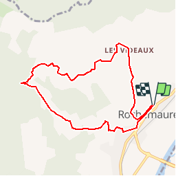
Ruta Senderismo de 8,8 km a descubrir en Auvergne-Rhône-Alpes, Ardecha, Rochemaure. Esta ruta ha sido propuesta por tracegps.
Descripción
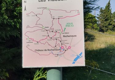
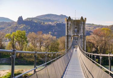
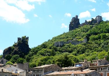
Promenade à Rochemaure sur le sentier botanique et son château perché. La suite et d’autres informations et photos sur le site des Balades de Stéphane.
Localización
País:
France
Región :
Auvergne-Rhône-Alpes
Departamento/provincia :
Ardecha
Municipio :
Rochemaure
Localidad:
Unknown
Salida:(Dec)
Salida:(UTM)
635327 ; 4938712 (31T) N.
Comentarios
Excursiones cerca
![Excursión Senderismo Meysse - Messe - pic chenavari -chateau de rochemaure - Photo](https://media.geolcdn.com/t/375/260/446a9ac6-cc6d-4429-b7ae-6be08bd52b14.jpg&format=jpg&maxdim=2)
![Senderismo Senderismo](https://static1.geolcdn.com/sitytour/trail-icons/101.png)
Messe - pic chenavari -chateau de rochemaure
Senderismo
Medio
(2)
Meysse,
Auvergne-Rhône-Alpes,
Ardecha,
France
![](/images/other/stat-length.png)
15 km | 23 km-effort
3h 51min
![](https://static1.geolcdn.com/siteimages/upload/files/16400158638029165_repeat_loop_refresh_sync_direction_icon.png)
Sí
![Excursión Senderismo Rochemaure - Randonnée entre Rochemaure et Aubignas - Photo](https://media.geolcdn.com/t/375/260/ext.jpg?maxdim=2&url=https%3A%2F%2Fservices.sitytrail.com%2FGeolivesWS%2FDownloadMedia.ashx%3FTrailID%3D104553%26Media%3D7931_3.jpg)
![Senderismo Senderismo](https://static1.geolcdn.com/sitytour/trail-icons/101.png)
Randonnée entre Rochemaure et Aubignas
Senderismo
Difícil
(2)
Rochemaure,
Auvergne-Rhône-Alpes,
Ardecha,
France
![](/images/other/stat-length.png)
16,8 km | 26 km-effort
5h 30min
![](https://static1.geolcdn.com/siteimages/upload/files/16400158638029165_repeat_loop_refresh_sync_direction_icon.png)
Sí
![Excursión Senderismo Rochemaure - Le Chenavary 11km. - Photo](https://media.geolcdn.com/t/375/260/dfb34e99-cb97-4de8-a99a-52eb6b293bd1.jpg&format=jpg&maxdim=2)
![Senderismo Senderismo](https://static1.geolcdn.com/sitytour/trail-icons/101.png)
Le Chenavary 11km.
Senderismo
Difícil
Rochemaure,
Auvergne-Rhône-Alpes,
Ardecha,
France
![](/images/other/stat-length.png)
11 km | 17,3 km-effort
3h 56min
![](https://static1.geolcdn.com/siteimages/upload/files/16400158638029165_repeat_loop_refresh_sync_direction_icon.png)
Sí
![Excursión Senderismo Ancône - 2022-09-27_13h14m41_14402810-1 - Photo](https://media.geolcdn.com/t/375/260/cb008533-e372-48c7-9f09-091e6cae99d0.jpg&format=jpg&maxdim=2)
![Senderismo Senderismo](https://static1.geolcdn.com/sitytour/trail-icons/101.png)
2022-09-27_13h14m41_14402810-1
Senderismo
Medio
Ancône,
Auvergne-Rhône-Alpes,
Drôme,
France
![](/images/other/stat-length.png)
16,1 km | 17,6 km-effort
4h 0min
![](https://static1.geolcdn.com/siteimages/upload/files/16400158638029165_repeat_loop_refresh_sync_direction_icon.png)
Sí
![Excursión Senderismo Le Teil - 2022-03-12_18h03m07_Le Teil 8 km.gpx (2).xml - Photo](https://media.geolcdn.com/t/375/260/ext.jpg?maxdim=2&url=https%3A%2F%2Fstatic1.geolcdn.com%2Fsiteimages%2Fupload%2Ffiles%2F1553511878bg_sport_marche.png)
![Senderismo Senderismo](https://static1.geolcdn.com/sitytour/trail-icons/101.png)
2022-03-12_18h03m07_Le Teil 8 km.gpx (2).xml
Senderismo
Medio
(1)
Le Teil,
Auvergne-Rhône-Alpes,
Ardecha,
France
![](/images/other/stat-length.png)
8,3 km | 10,2 km-effort
2h 17min
![](https://static1.geolcdn.com/siteimages/upload/files/16400158638029165_repeat_loop_refresh_sync_direction_icon.png)
Sí
![Excursión Marcha nórdica Montélimar - 20191002 MN Hymalaya - Photo](https://media.geolcdn.com/t/375/260/ext.jpg?maxdim=2&url=https%3A%2F%2Fstatic1.geolcdn.com%2Fsiteimages%2Fupload%2Ffiles%2F1545311037marcheuse_200dpi.jpg)
![Marcha nórdica Marcha nórdica](https://static1.geolcdn.com/sitytour/trail-icons/102.png)
20191002 MN Hymalaya
Marcha nórdica
Muy fácil
(1)
Montélimar,
Auvergne-Rhône-Alpes,
Drôme,
France
![](/images/other/stat-length.png)
7,7 km | 8,4 km-effort
1h 49min
![](https://static1.geolcdn.com/siteimages/upload/files/16400158638029165_repeat_loop_refresh_sync_direction_icon.png)
Sí
![Excursión Senderismo Rochemaure - tour du chenavari - Photo](https://media.geolcdn.com/t/375/260/ext.jpg?maxdim=2&url=https%3A%2F%2Fstatic1.geolcdn.com%2Fsiteimages%2Fupload%2Ffiles%2F1553511878bg_sport_marche.png)
![Senderismo Senderismo](https://static1.geolcdn.com/sitytour/trail-icons/101.png)
tour du chenavari
Senderismo
Medio
(1)
Rochemaure,
Auvergne-Rhône-Alpes,
Ardecha,
France
![](/images/other/stat-length.png)
6,3 km | 9,5 km-effort
2h 0min
![](https://static1.geolcdn.com/siteimages/upload/files/16400158638029165_repeat_loop_refresh_sync_direction_icon.png)
Sí
![Excursión Senderismo Rochemaure - Château de Rochemaure, Pic de Chenavari. - Photo](https://media.geolcdn.com/t/375/260/6c8a3c6f-4dcf-44b9-a997-a4440eb044c8.jpg&format=jpg&maxdim=2)
![Senderismo Senderismo](https://static1.geolcdn.com/sitytour/trail-icons/101.png)
Château de Rochemaure, Pic de Chenavari.
Senderismo
Difícil
Rochemaure,
Auvergne-Rhône-Alpes,
Ardecha,
France
![](/images/other/stat-length.png)
16,6 km | 26 km-effort
5h 58min
![](https://static1.geolcdn.com/siteimages/upload/files/16400158638029165_repeat_loop_refresh_sync_direction_icon.png)
Sí
![Senderismo Senderismo](https://static1.geolcdn.com/sitytour/trail-icons/101.png)
2024-09-28_21h46m05_13777682
Senderismo
Difícil
Rochemaure,
Auvergne-Rhône-Alpes,
Ardecha,
France
![](/images/other/stat-length.png)
12,2 km | 18,1 km-effort
4h 7min
![](https://static1.geolcdn.com/siteimages/upload/files/16400158638029165_repeat_loop_refresh_sync_direction_icon.png)
Sí
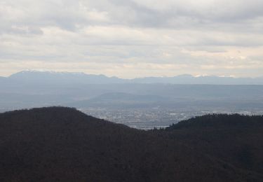
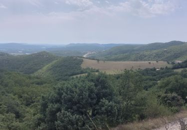
Début un peu difficile (ça monte fort) mais quelle récompense au dessus, des vues sur la vallée du Rhône et sur le château de rochemaure, on croise le chemin de quelques rapaces. très belle promenade
Bien