![](/images/other/stat-length.png)
![Excursión Senderismo Dabo - Dabo le rocher St-Léon - Photo](https://media.geolcdn.com/t/1900/400/ext.pjpeg?maxdim=2&url=https%3A%2F%2Fservices.sitytrail.com%2FGeolivesWS%2FDownloadMedia.ashx%3FTrailID%3D109887%26Media%3D4894_1.jpg)
Dabo le rocher St-Léon
tracegps
Usuario
![Longitud](/images/other/stat-length.png)
Longitud
11,8 km
![Altitud máxima](https://static1.geolcdn.com/siteimages/upload/files/1508320355ic_sort_altitude_max_24dp.png)
Altitud máxima
808 m
![Desnivel positivo](https://static1.geolcdn.com/siteimages/upload/files/1508320355ic_sort_den_pos_24dp.png)
Desnivel positivo
376 m
![Km-Effort](/images/other/stat-length.png)
Km-Effort
16,9 km
![Altitud mínima](https://static1.geolcdn.com/siteimages/upload/files/1508320355ic_sort_altitude_min_24dp.png)
Altitud mínima
470 m
![Desnivel negativo](https://static1.geolcdn.com/siteimages/upload/files/1508320355ic_sort_den_neg_24dp.png)
Desnivel negativo
375 m
![Boucle](https://static1.geolcdn.com/siteimages/upload/files/16400158638029165_repeat_loop_refresh_sync_direction_icon.png)
Boucle
Sí
Fecha de creación :
2014-12-10 00:00:00.0
Última modificación :
2014-12-10 00:00:00.0
![Senderismo](https://static1.geolcdn.com/sitytour/trail-icons/101.png)
3h00
Dificultad : Medio
![Escanee este código QR para abrir la excursión en la aplicación SityTrail](https://capi.geolives.com/qq0zvz2zws4bq2lad0pu/sitytour/trails/109887/qr.png?size=200)
Aplicación GPS de excursión GRATIS
A propósito
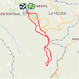
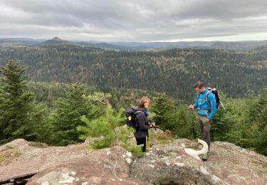
Ruta Senderismo de 11,8 km a descubrir en Gran Este, Mosela, Dabo. Esta ruta ha sido propuesta por tracegps.
Descripción
Promenade depuis le village de Dabo en Moselle vers le col de la Schleif et retour par le rocher St-Léon à travers les forêts du massif des Vosges. D’autres informations et photos sur le site des Balades de Stéphane.
Localización
País:
France
Región :
Gran Este
Departamento/provincia :
Mosela
Municipio :
Dabo
Localidad:
Unknown
Salida:(Dec)
Salida:(UTM)
370120 ; 5390430 (32U) N.
Comentarios
Excursiones cerca
![Excursión Senderismo Reinhardsmunster - 2020-06-13 Marche Ditschelkopf Schweizerberg - Photo](https://media.geolcdn.com/t/375/260/d6670ae9-2bf3-459d-a4b8-1c117627d287.jpg&format=jpg&maxdim=2)
![Senderismo Senderismo](https://static1.geolcdn.com/sitytour/trail-icons/101.png)
2020-06-13 Marche Ditschelkopf Schweizerberg
Senderismo
Muy fácil
Reinhardsmunster,
Gran Este,
Bajo-Rin,
France
![](/images/other/stat-length.png)
14,5 km | 22 km-effort
4h 52min
![](https://static1.geolcdn.com/siteimages/upload/files/16400158638029165_repeat_loop_refresh_sync_direction_icon.png)
Sí
![Excursión Senderismo Wangenbourg-Engenthal - 2020-03-14 Marche Engenthal le bas - Photo](https://media.geolcdn.com/t/375/260/ba70735c-7023-4458-a456-f43a6f2e7606.jpg&format=jpg&maxdim=2)
![Senderismo Senderismo](https://static1.geolcdn.com/sitytour/trail-icons/101.png)
2020-03-14 Marche Engenthal le bas
Senderismo
Muy fácil
Wangenbourg-Engenthal,
Gran Este,
Bajo-Rin,
France
![](/images/other/stat-length.png)
14,3 km | 22 km-effort
4h 27min
![](https://static1.geolcdn.com/siteimages/upload/files/16400158638029165_repeat_loop_refresh_sync_direction_icon.png)
Sí
![Excursión Senderismo Wangenbourg-Engenthal - 2017-02-24 Marche Schneeberg - Photo](https://media.geolcdn.com/t/375/260/ext.jpg?maxdim=2&url=https%3A%2F%2Fstatic1.geolcdn.com%2Fsiteimages%2Fupload%2Ffiles%2F1553511878bg_sport_marche.png)
![Senderismo Senderismo](https://static1.geolcdn.com/sitytour/trail-icons/101.png)
2017-02-24 Marche Schneeberg
Senderismo
Muy fácil
(1)
Wangenbourg-Engenthal,
Gran Este,
Bajo-Rin,
France
![](/images/other/stat-length.png)
12,8 km | 19,9 km-effort
Desconocido
![](https://static1.geolcdn.com/siteimages/upload/files/16400158638029165_repeat_loop_refresh_sync_direction_icon.png)
Sí
![Excursión Senderismo Haselbourg - De Haselbourg au Rocher de Falkenfels - Photo](https://media.geolcdn.com/t/375/260/ext.jpg?maxdim=2&url=https%3A%2F%2Fservices.sitytrail.com%2FGeolivesWS%2FDownloadMedia.ashx%3FTrailID%3D348689%26Media%3Da014c99e-bd4e-468a-9561-eeb2cbdf0f57.JPG)
![Senderismo Senderismo](https://static1.geolcdn.com/sitytour/trail-icons/101.png)
De Haselbourg au Rocher de Falkenfels
Senderismo
Fácil
(2)
Haselbourg,
Gran Este,
Mosela,
France
![](/images/other/stat-length.png)
6,4 km | 9,7 km-effort
2h 6min
![](https://static1.geolcdn.com/siteimages/upload/files/16400158638029165_repeat_loop_refresh_sync_direction_icon.png)
Sí
![Excursión Bici de montaña Dabo - Balcon de Dabo 2010 - Photo](https://media.geolcdn.com/t/375/260/ext.jpg?maxdim=2&url=https%3A%2F%2Fstatic1.geolcdn.com%2Fsiteimages%2Fupload%2Ffiles%2F1524743154velo.jpg)
![Bici de montaña Bici de montaña](https://static1.geolcdn.com/sitytour/trail-icons/202.png)
Balcon de Dabo 2010
Bici de montaña
Muy difícil
(1)
Dabo,
Gran Este,
Mosela,
France
![](/images/other/stat-length.png)
39 km | 54 km-effort
4h 30min
![](https://static1.geolcdn.com/siteimages/upload/files/16400158638029165_repeat_loop_refresh_sync_direction_icon.png)
Sí
![Excursión Senderismo Wangenbourg-Engenthal - obersteigen - Photo](https://media.geolcdn.com/t/375/260/1627429b-7fff-427f-af0e-c37d2da3b0ec.jpg&format=jpg&maxdim=2)
![Senderismo Senderismo](https://static1.geolcdn.com/sitytour/trail-icons/101.png)
obersteigen
Senderismo
Difícil
Wangenbourg-Engenthal,
Gran Este,
Bajo-Rin,
France
![](/images/other/stat-length.png)
44 km | 59 km-effort
5h 56min
![](https://static1.geolcdn.com/siteimages/upload/files/16400158638029165_repeat_loop_refresh_sync_direction_icon.png)
No
![Excursión Paseo ecuestre Dabo - Tour de dabo Tivio Joyeux - Photo](https://media.geolcdn.com/t/375/260/76dac64e-0da6-4de1-a424-f40eae7e5699.jpg&format=jpg&maxdim=2)
![Paseo ecuestre Paseo ecuestre](https://static1.geolcdn.com/sitytour/trail-icons/301.png)
Tour de dabo Tivio Joyeux
Paseo ecuestre
Medio
Dabo,
Gran Este,
Mosela,
France
![](/images/other/stat-length.png)
18 km | 25 km-effort
3h 14min
![](https://static1.geolcdn.com/siteimages/upload/files/16400158638029165_repeat_loop_refresh_sync_direction_icon.png)
No
![Excursión Senderismo Dabo - 2022-11-01 Marche Dabo et ses Rochers - Photo](https://media.geolcdn.com/t/375/260/63c4e37b-f9cd-403d-a535-8b98d78038cb.jpg&format=jpg&maxdim=2)
![Senderismo Senderismo](https://static1.geolcdn.com/sitytour/trail-icons/101.png)
2022-11-01 Marche Dabo et ses Rochers
Senderismo
Muy difícil
Dabo,
Gran Este,
Mosela,
France
![](/images/other/stat-length.png)
26 km | 38 km-effort
7h 8min
![](https://static1.geolcdn.com/siteimages/upload/files/16400158638029165_repeat_loop_refresh_sync_direction_icon.png)
Sí
![Excursión Senderismo Reinhardsmunster - Schuetzenfelsen - Photo](https://media.geolcdn.com/t/375/260/04510d63-cfd1-486f-ab25-499ccfd06d58.jpg&format=jpg&maxdim=2)
![Senderismo Senderismo](https://static1.geolcdn.com/sitytour/trail-icons/101.png)
Schuetzenfelsen
Senderismo
Medio
Reinhardsmunster,
Gran Este,
Bajo-Rin,
France
![](/images/other/stat-length.png)
12,4 km | 17 km-effort
3h 21min
![](https://static1.geolcdn.com/siteimages/upload/files/16400158638029165_repeat_loop_refresh_sync_direction_icon.png)
Sí