![](/images/other/stat-length.png)
![Excursión Senderismo Lendou-en-Quercy - Lascabanes - Montlauzun - Chemin de Compostelle - Photo](https://media.geolcdn.com/t/1900/400/ext.pjpeg?maxdim=2&url=https%3A%2F%2Fservices.sitytrail.com%2FGeolivesWS%2FDownloadMedia.ashx%3FTrailID%3D109553%26Media%3D4157_5.jpg)
Lascabanes - Montlauzun - Chemin de Compostelle
tracegps
Usuario
![Longitud](/images/other/stat-length.png)
![Altitud máxima](https://static1.geolcdn.com/siteimages/upload/files/1508320355ic_sort_altitude_max_24dp.png)
![Desnivel positivo](https://static1.geolcdn.com/siteimages/upload/files/1508320355ic_sort_den_pos_24dp.png)
![Km-Effort](/images/other/stat-length.png)
![Altitud mínima](https://static1.geolcdn.com/siteimages/upload/files/1508320355ic_sort_altitude_min_24dp.png)
![Desnivel negativo](https://static1.geolcdn.com/siteimages/upload/files/1508320355ic_sort_den_neg_24dp.png)
![Boucle](https://static1.geolcdn.com/siteimages/upload/files/16400158638029165_repeat_loop_refresh_sync_direction_icon.png)
![Senderismo](https://static1.geolcdn.com/sitytour/trail-icons/101.png)
6h49
Dificultad : Difícil
![Escanee este código QR para abrir la excursión en la aplicación SityTrail](https://capi.geolives.com/qq0zvz2zws4bq2lad0pu/sitytour/trails/109553/qr.png?size=200)
Aplicación GPS de excursión GRATIS
A propósito
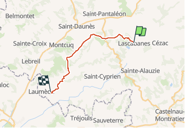
Ruta Senderismo de 14,8 km a descubrir en Occitania, Lot, Lendou-en-Quercy. Esta ruta ha sido propuesta por tracegps.
Descripción
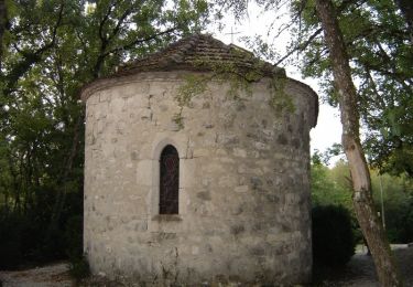
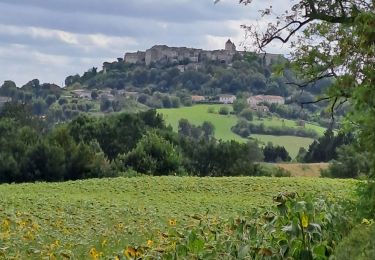
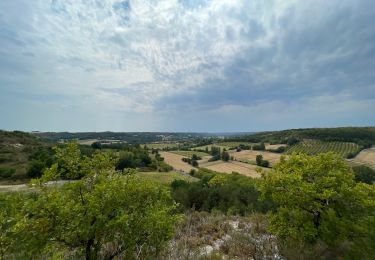
Lever 7H et petit déjeuner au Gîte communal (Gîte d'étape de Lascabanes, Mme Cécile Maupoux, Gîte : 05 65 31 49 12, Domicile : 05 65 31 86 38). Départ 9H pour une petite étape. Prendre à droite de l'église le chemin menant à St Géry et le quitter au bout de 250m pour un chemin de terre à gauche montant à Sabatier (0:10) et rejoignant une route goudronnée qu'il faut prendre à droite sur environ 500m. Prendre à gauche et passer devant la Chapelle St Jean (0:40). Poursuivre globalement vers l'Ouest jusqu'à croiser la D37 (1:20) puis rejoindre la D4 (2 :15). Après 600m environ, le temps étant à la pluie, nous avons pris la variante du GR65 consistant à éviter de passer à Montcuq. Quitter la D4 pour se diriger Sud Ouest et croiser la D55 (2:50). Peu après, nous avons trouvé abris sous un arbre pour notre pique nique (2:50). (4:05) Après avoir dépasser Clos de Vilas et Cantegord, on rattrape la voie normale du GR65. Prendre à gauche la D28 et immédiatement à gauche le chemin menant au Château de Charry (4:35). Après 200m, prendre à droite un sentier longeant la propriété du château, croiser la D28 à Roux et rejoindre la vallée du Tartugulé (5:10). Prendre à droite la route goudronnée et passer sous Rouillac (ou mieux, aller visiter la magnifique chapelle ornée) puis traverser le Tartugulé pour remonter vers Bonal (5:45) où des boissons vous attendent ! Une petite halte s'impose ! Descendre vers Les Grèzes et au croisement, prendre à droite vers Le Sorbier et Colombelle. Dans la cote qui suit, prendre à droite vers Montlauzun (6:50). Nous avions réservé nos nuités et nos repas au gîte de l'Ancien Presbytère (Chris et Eileen Gillon, 05 65 36 04 02 ou 05 65 36 01 31). Très beau gîte avec une vue superbe, on n'est pas à Montlauzun pour rien ! Accueil sympathique et très bonne prestation.
Localización
Comentarios
Excursiones cerca
![Excursión Senderismo Barguelonne-en-Quercy - St-Pantaleon - Photo](https://media.geolcdn.com/t/375/260/0d52d715-f32d-4e06-af5a-3c3459733c5f.jpg&format=jpg&maxdim=2)
![Senderismo Senderismo](https://static1.geolcdn.com/sitytour/trail-icons/101.png)
Senderismo
![](/images/other/stat-length.png)
![](https://static1.geolcdn.com/siteimages/upload/files/16400158638029165_repeat_loop_refresh_sync_direction_icon.png)
![Excursión Senderismo Lendou-en-Quercy - Tronçon St Jacques Lascabane Lauzerte - Photo](https://media.geolcdn.com/t/375/260/36b9e87f-0d07-4ad1-9c3c-e3610bc5a08b.jpg&format=jpg&maxdim=2)
![Senderismo Senderismo](https://static1.geolcdn.com/sitytour/trail-icons/101.png)
Senderismo
![](/images/other/stat-length.png)
![](https://static1.geolcdn.com/siteimages/upload/files/16400158638029165_repeat_loop_refresh_sync_direction_icon.png)
![Senderismo Senderismo](https://static1.geolcdn.com/sitytour/trail-icons/101.png)
Senderismo
![](/images/other/stat-length.png)
![](https://static1.geolcdn.com/siteimages/upload/files/16400158638029165_repeat_loop_refresh_sync_direction_icon.png)
![Excursión Senderismo Lendou-en-Quercy - Circuit de St Jean de Froid et de Marranes - Lascabanes - Photo](https://media.geolcdn.com/t/375/260/ext.jpg?maxdim=2&url=https%3A%2F%2Fservices.sitytrail.com%2FGeolivesWS%2FDownloadMedia.ashx%3FTrailID%3D111753%26Media%3D8191_6.jpg)
![Senderismo Senderismo](https://static1.geolcdn.com/sitytour/trail-icons/101.png)
Senderismo
![](/images/other/stat-length.png)
![](https://static1.geolcdn.com/siteimages/upload/files/16400158638029165_repeat_loop_refresh_sync_direction_icon.png)
![Excursión Senderismo Lendou-en-Quercy - durant lascabanne - Photo](https://media.geolcdn.com/t/375/260/944b0ce0-e2a6-4aad-b62a-68727759867c.jpg&format=jpg&maxdim=2)
![Senderismo Senderismo](https://static1.geolcdn.com/sitytour/trail-icons/101.png)
Senderismo
![](/images/other/stat-length.png)
![](https://static1.geolcdn.com/siteimages/upload/files/16400158638029165_repeat_loop_refresh_sync_direction_icon.png)
![Excursión Senderismo Lendou-en-Quercy - 2-Lascabanes-Lauzerte 25km - Photo](https://media.geolcdn.com/t/375/260/ext.jpg?maxdim=2&url=https%3A%2F%2Fstatic1.geolcdn.com%2Fsiteimages%2Fupload%2Ffiles%2F1553511878bg_sport_marche.png)
![Senderismo Senderismo](https://static1.geolcdn.com/sitytour/trail-icons/101.png)
Senderismo
![](/images/other/stat-length.png)
![](https://static1.geolcdn.com/siteimages/upload/files/16400158638029165_repeat_loop_refresh_sync_direction_icon.png)
![Excursión Senderismo Barguelonne-en-Quercy - Bagat - saint pantaleon - Photo](https://media.geolcdn.com/t/375/260/e2399be1-645f-42c3-8566-c3e24d71c7dc.jpg&format=jpg&maxdim=2)
![Senderismo Senderismo](https://static1.geolcdn.com/sitytour/trail-icons/101.png)
Senderismo
![](/images/other/stat-length.png)
![](https://static1.geolcdn.com/siteimages/upload/files/16400158638029165_repeat_loop_refresh_sync_direction_icon.png)
![Excursión Paseo ecuestre Lendou-en-Quercy - lascabanes - Photo](https://media.geolcdn.com/t/375/260/ext.jpg?maxdim=2&url=https%3A%2F%2Fstatic1.geolcdn.com%2Fsiteimages%2Fupload%2Ffiles%2F1524743154cheval.jpg)
![Paseo ecuestre Paseo ecuestre](https://static1.geolcdn.com/sitytour/trail-icons/301.png)
Paseo ecuestre
![](/images/other/stat-length.png)
![](https://static1.geolcdn.com/siteimages/upload/files/16400158638029165_repeat_loop_refresh_sync_direction_icon.png)
![Excursión Paseo ecuestre Lendou-en-Quercy - montcuq - Photo](https://media.geolcdn.com/t/375/260/ext.jpg?maxdim=2&url=https%3A%2F%2Fstatic1.geolcdn.com%2Fsiteimages%2Fupload%2Ffiles%2F1524743154cheval.jpg)
![Paseo ecuestre Paseo ecuestre](https://static1.geolcdn.com/sitytour/trail-icons/301.png)
Paseo ecuestre
![](/images/other/stat-length.png)
![](https://static1.geolcdn.com/siteimages/upload/files/16400158638029165_repeat_loop_refresh_sync_direction_icon.png)