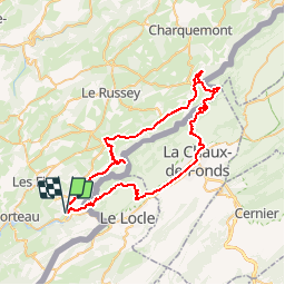
![](/images/other/stat-length.png)
![Excursión Bicicleta Villers-le-Lac - Le Saut du Doubs - Le Châtelot - Doubs - Photo](https://media.geolcdn.com/t/1900/400/ext.pjpeg?maxdim=2&url=https%3A%2F%2Fservices.sitytrail.com%2FGeolivesWS%2FDownloadMedia.ashx%3FTrailID%3D109432%26Media%3D3780_1.jpg)
Le Saut du Doubs - Le Châtelot - Doubs
tracegps
Usuario
![Longitud](/images/other/stat-length.png)
![Altitud máxima](https://static1.geolcdn.com/siteimages/upload/files/1508320355ic_sort_altitude_max_24dp.png)
![Desnivel positivo](https://static1.geolcdn.com/siteimages/upload/files/1508320355ic_sort_den_pos_24dp.png)
![Km-Effort](/images/other/stat-length.png)
![Altitud mínima](https://static1.geolcdn.com/siteimages/upload/files/1508320355ic_sort_altitude_min_24dp.png)
![Desnivel negativo](https://static1.geolcdn.com/siteimages/upload/files/1508320355ic_sort_den_neg_24dp.png)
![Boucle](https://static1.geolcdn.com/siteimages/upload/files/16400158638029165_repeat_loop_refresh_sync_direction_icon.png)
![Bicicleta](https://static1.geolcdn.com/sitytour/trail-icons/200.png)
3h30
Dificultad : Difícil
![Escanee este código QR para abrir la excursión en la aplicación SityTrail](https://capi.geolives.com/qq0zvz2zws4bq2lad0pu/sitytour/trails/109432/qr.png?size=200)
Aplicación GPS de excursión GRATIS
A propósito
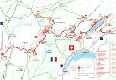
Ruta Bicicleta de 62 km a descubrir en Borgoña-Franco Condado, Doubs, Villers-le-Lac. Esta ruta ha sido propuesta por tracegps.
Descripción
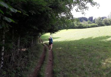
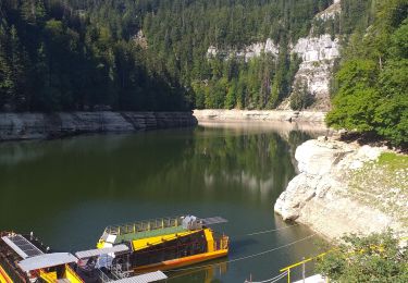
Le Doubs, réserve naturelle d’idées neuves ! Le Saut du Doubs – Le Châtelot Office de tourisme (03 81 68 00 98) - Musée de la Montre (03 81 68 08 00) - Musée de la Radio (03 81 68 00 59) - Embarcadères des compagnies de navigation vers le Saut du Doubs : CNFS Vedettes panoramiques (03 81 68 05 34) et Compagnie Droz-Bartholet (03 81 68 05 34) - Les Calèches du Saut du Doubs (03 81 68 09 03) - Chapelle St-Joseph des Bassots (XVIIe) - Lac de Chaillexon Entrée en Suisse A proximité : Ville du Locle : Musée d’horlogerie du Château des Monts, Moulin souterrain du Col des Roches… Ville de La Chaux-de-Fonds : Art nouveau, Musée international d’horlogerie, Musée des Beaux-Arts, Villa turque (Le Corbusier), Parc zoologique… Site de Biaufond Retour en France A proximité Les échelles de la mort Belvédère de la Cendrée à Charquemont Parc-aventure de la Combe Saint-Pierre Le barrage du Châtelot au Pissoux Le Saut du Doubs, chute d’eau de 27 m , classé Grand site national Les Bassins du Doubs
Localización
Comentarios
Excursiones cerca
![Excursión Senderismo Villers-le-Lac - Le saut du Doubs et le Châtelard - Photo](https://media.geolcdn.com/t/375/260/ext.jpg?maxdim=2&url=https%3A%2F%2Fservices.sitytrail.com%2FGeolivesWS%2FDownloadMedia.ashx%3FTrailID%3D792633%26Media%3Dfix__20170717135052.jpg)
![Senderismo Senderismo](https://static1.geolcdn.com/sitytour/trail-icons/101.png)
Senderismo
![](/images/other/stat-length.png)
![](https://static1.geolcdn.com/siteimages/upload/files/16400158638029165_repeat_loop_refresh_sync_direction_icon.png)
![Excursión A pie Le Locle - Hôtel du Saut du Doubs - Gare des Brenets - Photo](https://media.geolcdn.com/t/375/260/4e2b223b-5d1f-4722-b3d5-d37a87436a7c.jpeg&format=jpg&maxdim=2)
![A pie A pie](https://static1.geolcdn.com/sitytour/trail-icons/100.png)
A pie
![](/images/other/stat-length.png)
![](https://static1.geolcdn.com/siteimages/upload/files/16400158638029165_repeat_loop_refresh_sync_direction_icon.png)
![Excursión A pie Le Locle - Les Frêtes - fixme - Photo](https://media.geolcdn.com/t/375/260/0dfa81c4-ea86-4670-a9e2-4edd9205728f.jpeg&format=jpg&maxdim=2)
![A pie A pie](https://static1.geolcdn.com/sitytour/trail-icons/100.png)
A pie
![](/images/other/stat-length.png)
![](https://static1.geolcdn.com/siteimages/upload/files/16400158638029165_repeat_loop_refresh_sync_direction_icon.png)
![Excursión Senderismo Villers-le-Lac - Le Pisoux - Photo](https://media.geolcdn.com/t/375/260/4a715c23-f970-4542-83cb-bb9163df6e0f.jpg&format=jpg&maxdim=2)
![Senderismo Senderismo](https://static1.geolcdn.com/sitytour/trail-icons/101.png)
Senderismo
![](/images/other/stat-length.png)
![](https://static1.geolcdn.com/siteimages/upload/files/16400158638029165_repeat_loop_refresh_sync_direction_icon.png)
![Excursión Senderismo Villers-le-Lac - Saut du Doubs - Photo](https://media.geolcdn.com/t/375/260/5bf04ea4-00d2-4096-ab82-e6f5e7455237.jpg&format=jpg&maxdim=2)
![Senderismo Senderismo](https://static1.geolcdn.com/sitytour/trail-icons/101.png)
Senderismo
![](/images/other/stat-length.png)
![](https://static1.geolcdn.com/siteimages/upload/files/16400158638029165_repeat_loop_refresh_sync_direction_icon.png)
![Excursión Senderismo Montlebon - montlebon - Photo](https://media.geolcdn.com/t/375/260/157a0c36-6815-469b-9dc0-89ac9fc6cb61.jpg&format=jpg&maxdim=2)
![Senderismo Senderismo](https://static1.geolcdn.com/sitytour/trail-icons/101.png)
Senderismo
![](/images/other/stat-length.png)
![](https://static1.geolcdn.com/siteimages/upload/files/16400158638029165_repeat_loop_refresh_sync_direction_icon.png)
![Excursión Senderismo Villers-le-Lac - les brenets - Photo](https://media.geolcdn.com/t/375/260/a20ac90c-06ca-4725-aa0c-13349df47b73.jpg&format=jpg&maxdim=2)
![Senderismo Senderismo](https://static1.geolcdn.com/sitytour/trail-icons/101.png)
Senderismo
![](/images/other/stat-length.png)
![](https://static1.geolcdn.com/siteimages/upload/files/16400158638029165_repeat_loop_refresh_sync_direction_icon.png)
![Excursión Senderismo Morteau - Via Cluny: de Morteau (Montagnes du Jura) à Cluny (Bourgogne) - Photo](https://media.geolcdn.com/t/375/260/dc7b3bf6-401c-4f73-89ce-a5f06e0e1cb1.jpg&format=jpg&maxdim=2)
![Senderismo Senderismo](https://static1.geolcdn.com/sitytour/trail-icons/101.png)
Senderismo
![](/images/other/stat-length.png)
![](https://static1.geolcdn.com/siteimages/upload/files/16400158638029165_repeat_loop_refresh_sync_direction_icon.png)