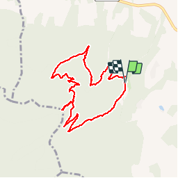
![](/images/other/stat-length.png)
![Excursión Senderismo Grane - Boucle pédestre n°40 - Mont Brian - Photo](https://media.geolcdn.com/t/1900/400/ext.pjpeg?maxdim=2&url=https%3A%2F%2Fservices.sitytrail.com%2FGeolivesWS%2FDownloadMedia.ashx%3FTrailID%3D109059%26Media%3D3081_1.jpg)
Boucle pédestre n°40 - Mont Brian
tracegps
Usuario
![Longitud](/images/other/stat-length.png)
![Altitud máxima](https://static1.geolcdn.com/siteimages/upload/files/1508320355ic_sort_altitude_max_24dp.png)
![Desnivel positivo](https://static1.geolcdn.com/siteimages/upload/files/1508320355ic_sort_den_pos_24dp.png)
![Km-Effort](/images/other/stat-length.png)
![Altitud mínima](https://static1.geolcdn.com/siteimages/upload/files/1508320355ic_sort_altitude_min_24dp.png)
![Desnivel negativo](https://static1.geolcdn.com/siteimages/upload/files/1508320355ic_sort_den_neg_24dp.png)
![Boucle](https://static1.geolcdn.com/siteimages/upload/files/16400158638029165_repeat_loop_refresh_sync_direction_icon.png)
![Senderismo](https://static1.geolcdn.com/sitytour/trail-icons/101.png)
2h45
Dificultad : Medio
![Escanee este código QR para abrir la excursión en la aplicación SityTrail](https://capi.geolives.com/qq0zvz2zws4bq2lad0pu/sitytour/trails/109059/qr.png?size=200)
Aplicación GPS de excursión GRATIS
A propósito
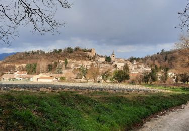
Ruta Senderismo de 8,9 km a descubrir en Auvergne-Rhône-Alpes, Drôme, Grane. Esta ruta ha sido propuesta por tracegps.
Descripción
Les randonnées pédestres de Grâne Rando Loisirs. Départ de l’IME de Val Brian, à 4 km à l’ouest de Grâne en direction de Loriol.: Belle balade entre un ancien couvent et le Mont Brian, mirador sur les vallées du Rhône et de la Drôme jusqu’au Vercors et Diois. Du Parking traverser l’IME vers le sud en direction de Parpaillones» Monchaud» et «Pied de Courcoussat» par un bon chemin qui devient sentier en direction de «Brian Nord» que l'on atteint en 35mn; de là on peu aller en aller-retour au sommet du mont Brian, de «Brian Nord» prendre le sentier en sous bois et en descente en direction de «Fonds de Brian», quitter le bon chemin pour un sentier à droite, descendre jusqu'aux maisons que l'on laisse à gauche, pour un sentier montant jusqu'à «L'Adret», là rester à gauche pour monter encore un peu et trouver une ancienne aire de battage de céréales avec un rouleau à cannelures. Retrouver un bon chemin, puis passer à droite le long du champ pour prendre dans le coin opposé un sentier descendant, vous ramenant au parking de l'IME. (Numérisation par Joël Vachon)
Localización
Comentarios
Excursiones cerca
![Excursión Senderismo Mirmande - Mirmande les Balcons du Rhône 12 km. - Photo](https://media.geolcdn.com/t/375/260/2e19df22-829f-49cb-be0c-e6a169988f7c.jpg&format=jpg&maxdim=2)
![Senderismo Senderismo](https://static1.geolcdn.com/sitytour/trail-icons/101.png)
Senderismo
![](/images/other/stat-length.png)
![](https://static1.geolcdn.com/siteimages/upload/files/16400158638029165_repeat_loop_refresh_sync_direction_icon.png)
![Excursión Senderismo Mirmande - 2023-09-29_07h20m46_Cirkwi-Balcon_du_Rhône(1) - Photo](https://media.geolcdn.com/t/375/260/65f7d0c4-9656-42ca-beca-cf82cff2d6f9.jpg&format=jpg&maxdim=2)
![Senderismo Senderismo](https://static1.geolcdn.com/sitytour/trail-icons/101.png)
Senderismo
![](/images/other/stat-length.png)
![](https://static1.geolcdn.com/siteimages/upload/files/16400158638029165_repeat_loop_refresh_sync_direction_icon.png)
![Excursión Senderismo Grane - Grane-Les Roberts 13km - Photo](https://media.geolcdn.com/t/375/260/5618d6af-4205-4e85-865b-a90a6c161a8c.jpg&format=jpg&maxdim=2)
![Senderismo Senderismo](https://static1.geolcdn.com/sitytour/trail-icons/101.png)
Senderismo
![](/images/other/stat-length.png)
![](https://static1.geolcdn.com/siteimages/upload/files/16400158638029165_repeat_loop_refresh_sync_direction_icon.png)
![Excursión Senderismo Grane - grane bois de la dame Pierre sanglante - Photo](https://media.geolcdn.com/t/375/260/ext.jpg?maxdim=2&url=https%3A%2F%2Fstatic1.geolcdn.com%2Fsiteimages%2Fupload%2Ffiles%2F1553511878bg_sport_marche.png)
![Senderismo Senderismo](https://static1.geolcdn.com/sitytour/trail-icons/101.png)
Senderismo
![](/images/other/stat-length.png)
![](https://static1.geolcdn.com/siteimages/upload/files/16400158638029165_repeat_loop_refresh_sync_direction_icon.png)
![Excursión Senderismo Mirmande - Mirmande - Photo](https://media.geolcdn.com/t/375/260/ext.jpg?maxdim=2&url=https%3A%2F%2Fstatic1.geolcdn.com%2Fsiteimages%2Fupload%2Ffiles%2F1553511878bg_sport_marche.png)
![Senderismo Senderismo](https://static1.geolcdn.com/sitytour/trail-icons/101.png)
Senderismo
![](/images/other/stat-length.png)
![](https://static1.geolcdn.com/siteimages/upload/files/16400158638029165_repeat_loop_refresh_sync_direction_icon.png)
![Excursión Senderismo Allex - Balade des Ramieres à livron - Photo](https://media.geolcdn.com/t/375/260/ext.jpg?maxdim=2&url=https%3A%2F%2Fstatic1.geolcdn.com%2Fsiteimages%2Fupload%2Ffiles%2F1553511878bg_sport_marche.png)
![Senderismo Senderismo](https://static1.geolcdn.com/sitytour/trail-icons/101.png)
Senderismo
![](/images/other/stat-length.png)
![](https://static1.geolcdn.com/siteimages/upload/files/16400158638029165_repeat_loop_refresh_sync_direction_icon.png)
![Excursión Senderismo Mirmande - Mirmande - Photo](https://media.geolcdn.com/t/375/260/2da286aa-7aa8-4366-a5c0-6dbf062bb022.jpg&format=jpg&maxdim=2)
![Senderismo Senderismo](https://static1.geolcdn.com/sitytour/trail-icons/101.png)
Senderismo
![](/images/other/stat-length.png)
![](https://static1.geolcdn.com/siteimages/upload/files/16400158638029165_repeat_loop_refresh_sync_direction_icon.png)
![Excursión Senderismo Livron-sur-Drôme - Livron Tour-du-Diable 10km - Photo](https://media.geolcdn.com/t/375/260/32c47bf7-f18d-4008-9d94-058ad16616d9.jpg&format=jpg&maxdim=2)
![Senderismo Senderismo](https://static1.geolcdn.com/sitytour/trail-icons/101.png)
Senderismo
![](/images/other/stat-length.png)
![](https://static1.geolcdn.com/siteimages/upload/files/16400158638029165_repeat_loop_refresh_sync_direction_icon.png)
![Senderismo Senderismo](https://static1.geolcdn.com/sitytour/trail-icons/101.png)
Senderismo
![](/images/other/stat-length.png)
![](https://static1.geolcdn.com/siteimages/upload/files/16400158638029165_repeat_loop_refresh_sync_direction_icon.png)
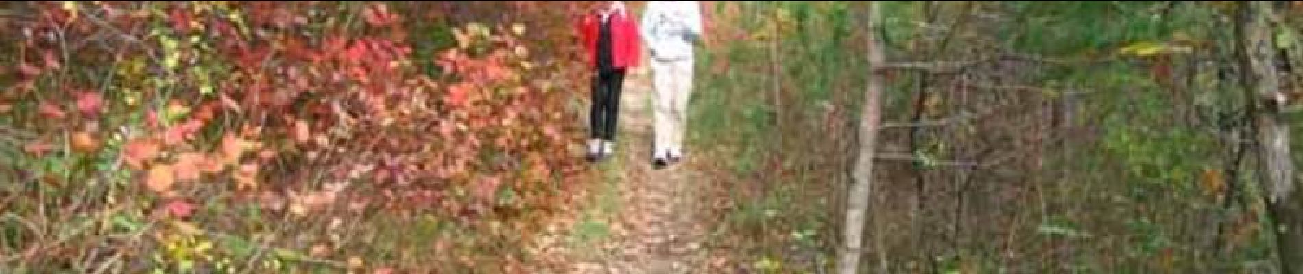
balade bien ombragée et peu fréquentée