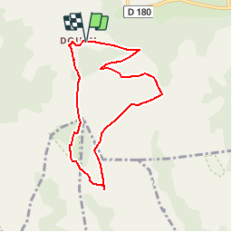
![](/images/other/stat-length.png)
![Excursión Senderismo Rosis - Petit tour du plateau du Caroux - Photo](https://media.geolcdn.com/t/1900/400/ext.pjpeg?maxdim=2&url=https%3A%2F%2Fservices.sitytrail.com%2FGeolivesWS%2FDownloadMedia.ashx%3FTrailID%3D109006%26Media%3D2950_1.jpg)
Petit tour du plateau du Caroux
tracegps
Usuario
![Longitud](/images/other/stat-length.png)
![Altitud máxima](https://static1.geolcdn.com/siteimages/upload/files/1508320355ic_sort_altitude_max_24dp.png)
![Desnivel positivo](https://static1.geolcdn.com/siteimages/upload/files/1508320355ic_sort_den_pos_24dp.png)
![Km-Effort](/images/other/stat-length.png)
![Altitud mínima](https://static1.geolcdn.com/siteimages/upload/files/1508320355ic_sort_altitude_min_24dp.png)
![Desnivel negativo](https://static1.geolcdn.com/siteimages/upload/files/1508320355ic_sort_den_neg_24dp.png)
![Boucle](https://static1.geolcdn.com/siteimages/upload/files/16400158638029165_repeat_loop_refresh_sync_direction_icon.png)
![Senderismo](https://static1.geolcdn.com/sitytour/trail-icons/101.png)
2h30
Dificultad : Medio
![Escanee este código QR para abrir la excursión en la aplicación SityTrail](https://capi.geolives.com/qq0zvz2zws4bq2lad0pu/sitytour/trails/109006/qr.png?size=200)
Aplicación GPS de excursión GRATIS
A propósito
Ruta Senderismo de 7,8 km a descubrir en Occitania, Hérault, Rosis. Esta ruta ha sido propuesta por tracegps.
Descripción
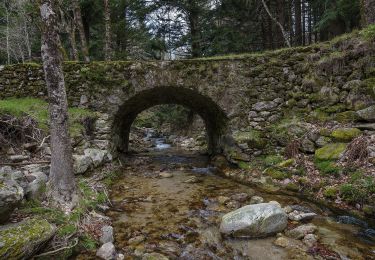
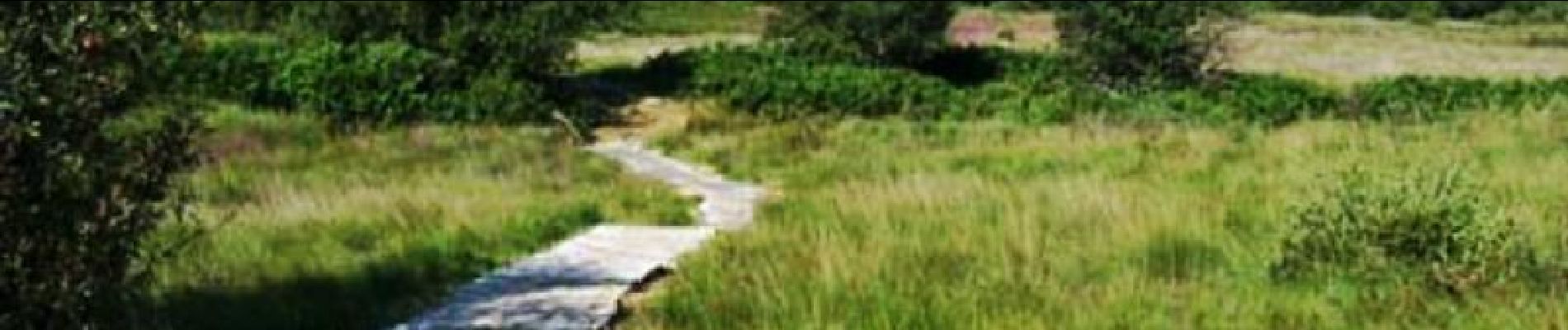
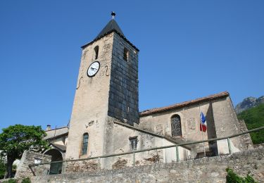
Source La Maison Cévenole des Arts et Traditions Populaires Saint Gervais sur Mare est situé dans le haut Hérault, aux confins du Tarn et de l'Aveyron. Le village qui se trouve à environ 350m d'altitude est entouré de sommets qui atteignent 1000 mètres et qui font la limite de partage des eaux entre les versants méditerranéen et atlantique. Circuit n°10 Courte randonnée agréable permettant de découvrir le plateau du Caroux, et ses panoramas exceptionnels sur le Languedoc. Note sur le parcours en VTT. Quelques passages pénibles entre 2 et 3 (sentier). Le parcours du plateau est très agréable et sans difficulté, nombreuses variantes possibles. La descente finale sur Douch est trop raide et réservée à un public averti. Tourner à droite et contourner la butte 1085 par une piste forestière pour rejoindre ... Redescendre au parking par la « route de la honte ». Toutes les infos sont disponibles sur les fiches téléchargeables ICI
Localización
Comentarios
Excursiones cerca
![Excursión Senderismo Colombières-sur-Orb - Colombières sur Orb - Photo](https://media.geolcdn.com/t/375/260/ext.jpg?maxdim=2&url=https%3A%2F%2Fservices.sitytrail.com%2FGeolivesWS%2FDownloadMedia.ashx%3FTrailID%3D350907%26Media%3Dfix__20140914134818.jpg)
![Senderismo Senderismo](https://static1.geolcdn.com/sitytour/trail-icons/101.png)
Senderismo
![](/images/other/stat-length.png)
![](https://static1.geolcdn.com/siteimages/upload/files/16400158638029165_repeat_loop_refresh_sync_direction_icon.png)
![Excursión Senderismo Colombières-sur-Orb - Les gorges de Colombières - Photo](https://media.geolcdn.com/t/375/260/ext.jpg?maxdim=2&url=https%3A%2F%2Fservices.sitytrail.com%2FGeolivesWS%2FDownloadMedia.ashx%3FTrailID%3D335244%26Media%3Dfix__20140805142334.jpg)
![Senderismo Senderismo](https://static1.geolcdn.com/sitytour/trail-icons/101.png)
Senderismo
![](/images/other/stat-length.png)
![](https://static1.geolcdn.com/siteimages/upload/files/16400158638029165_repeat_loop_refresh_sync_direction_icon.png)
![Excursión Senderismo Colombières-sur-Orb - Les gorges de Colombières - retour sentier de la Buffe - Photo](https://media.geolcdn.com/t/375/260/ext.jpg?maxdim=2&url=https%3A%2F%2Fservices.sitytrail.com%2FGeolivesWS%2FDownloadMedia.ashx%3FTrailID%3D129712%26Media%3D13257_6.jpg)
![Senderismo Senderismo](https://static1.geolcdn.com/sitytour/trail-icons/101.png)
Senderismo
![](/images/other/stat-length.png)
![](https://static1.geolcdn.com/siteimages/upload/files/16400158638029165_repeat_loop_refresh_sync_direction_icon.png)
![Excursión Senderismo Colombières-sur-Orb - 34 colombier sur orb - Photo](https://media.geolcdn.com/t/375/260/ed1e5c61-79a3-4908-ab1a-6d651ba5ba36.jpg&format=jpg&maxdim=2)
![Senderismo Senderismo](https://static1.geolcdn.com/sitytour/trail-icons/101.png)
Senderismo
![](/images/other/stat-length.png)
![](https://static1.geolcdn.com/siteimages/upload/files/16400158638029165_repeat_loop_refresh_sync_direction_icon.png)
![Excursión Senderismo Saint-Martin-de-l'Arçon - 34 caroux - Photo](https://media.geolcdn.com/t/375/260/68524901-f808-4b7c-83cf-daed4ea0a516.jpg&format=jpg&maxdim=2)
![Senderismo Senderismo](https://static1.geolcdn.com/sitytour/trail-icons/101.png)
Senderismo
![](/images/other/stat-length.png)
![](https://static1.geolcdn.com/siteimages/upload/files/16400158638029165_repeat_loop_refresh_sync_direction_icon.png)
![Excursión Senderismo Mons - 34 gorges Heric Mons 07.07.23 - Photo](https://media.geolcdn.com/t/375/260/06d551fc-4779-4ba0-8ab8-14fd17f32f20.jpg&format=jpg&maxdim=2)
![Senderismo Senderismo](https://static1.geolcdn.com/sitytour/trail-icons/101.png)
Senderismo
![](/images/other/stat-length.png)
![](https://static1.geolcdn.com/siteimages/upload/files/16400158638029165_repeat_loop_refresh_sync_direction_icon.png)
![Excursión Senderismo Mons - Le sentier des Gardes / Douch / Héric - Photo](https://media.geolcdn.com/t/375/260/ext.jpg?maxdim=2&url=https%3A%2F%2Fstatic1.geolcdn.com%2Fsiteimages%2Fupload%2Ffiles%2F1553511878bg_sport_marche.png)
![Senderismo Senderismo](https://static1.geolcdn.com/sitytour/trail-icons/101.png)
Senderismo
![](/images/other/stat-length.png)
![](https://static1.geolcdn.com/siteimages/upload/files/16400158638029165_repeat_loop_refresh_sync_direction_icon.png)
![Excursión A pie Colombières-sur-Orb - GRP Les gorges de Colombières - Photo](https://media.geolcdn.com/t/375/260/41796b95-b1ee-46e7-97f8-cdd9e3a51e62.jpeg&format=jpg&maxdim=2)
![A pie A pie](https://static1.geolcdn.com/sitytour/trail-icons/100.png)
A pie
![](/images/other/stat-length.png)
![](https://static1.geolcdn.com/siteimages/upload/files/16400158638029165_repeat_loop_refresh_sync_direction_icon.png)
![Excursión A pie Rosis - Le Vialaïs - Photo](https://media.geolcdn.com/t/375/260/2e621447-c736-4c4c-b528-334f5c0d87f0.jpeg&format=jpg&maxdim=2)
![A pie A pie](https://static1.geolcdn.com/sitytour/trail-icons/100.png)