![](/images/other/stat-length.png)
![Excursión Senderismo Sélestat - Sentier de l'Illwald - Photo](https://media.geolcdn.com/t/1900/400/ext.pjpeg?maxdim=2&url=https%3A%2F%2Fservices.sitytrail.com%2FGeolivesWS%2FDownloadMedia.ashx%3FTrailID%3D108918%26Media%3D2607_1.jpg)
Sentier de l'Illwald
tracegps
Usuario
![Longitud](/images/other/stat-length.png)
![Altitud máxima](https://static1.geolcdn.com/siteimages/upload/files/1508320355ic_sort_altitude_max_24dp.png)
![Desnivel positivo](https://static1.geolcdn.com/siteimages/upload/files/1508320355ic_sort_den_pos_24dp.png)
![Km-Effort](/images/other/stat-length.png)
![Altitud mínima](https://static1.geolcdn.com/siteimages/upload/files/1508320355ic_sort_altitude_min_24dp.png)
![Desnivel negativo](https://static1.geolcdn.com/siteimages/upload/files/1508320355ic_sort_den_neg_24dp.png)
![Boucle](https://static1.geolcdn.com/siteimages/upload/files/16400158638029165_repeat_loop_refresh_sync_direction_icon.png)
![Senderismo](https://static1.geolcdn.com/sitytour/trail-icons/101.png)
3h45
Dificultad : Medio
![Escanee este código QR para abrir la excursión en la aplicación SityTrail](https://capi.geolives.com/qq0zvz2zws4bq2lad0pu/sitytour/trails/108918/qr.png?size=200)
Aplicación GPS de excursión GRATIS
A propósito
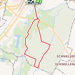
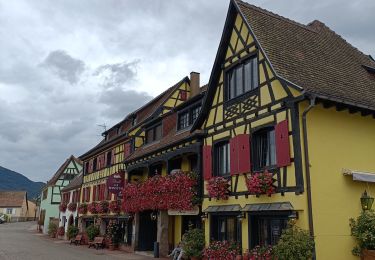
Ruta Senderismo de 13,2 km a descubrir en Gran Este, Bajo-Rin, Sélestat. Esta ruta ha sido propuesta por tracegps.
Descripción
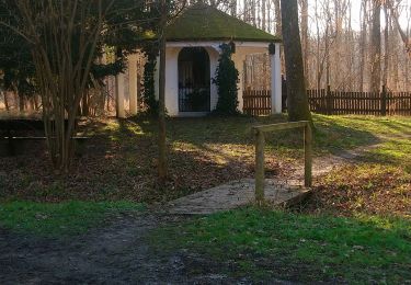
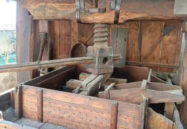
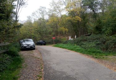
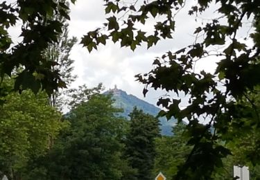
Circuit proposé par l’Agence de Développement Touristique du Bas-Rhin. Le grand ried de l’Ill, entre Sélestat et le Rhin, est le plus vaste d’Alsace. Il se caractérise par un réseau dense de rivières, dont beaucoup sont phréatiques, une faune et une flore très riches (courlis, une des plus importantes populations de daims sauvages de France…). Ce circuit nous emmène plus précisément à la découverte du ried de Sélestat qui correspond au champ d’inondation de l’Ill, encore actif de nos jours, à la différence du ried rhénan. Ce secteur est classé réserve naturelle volontaire sur près de 1800 hectares. Depuis le pont de l’Ill à Sélestat, le sentier gagne le Hollockgraben, un fossé d’irrigation et de drainage qu’il longe pour rejoindre plus loin le cours de l’Ill. En entrant dans la forêt de l’Illwald, nous mettons le cap à l’est pour franchir successivement une multitude de cours d’eau : le Krummlach, le Forstlach, le Petit Rheinweg, le Schiffwasser et remonter vers le nord parallèlement au Oberriedgraben. A la chapelle du Chêne, le circuit rallie le Schiffwasser avant de regagner Sélestat. Retrouvez toutes les informations nécessaires ICI
Localización
Comentarios
Excursiones cerca
![Excursión Senderismo Châtenois - Le Hahnenberg et les balcons Sélestat - Photo](https://media.geolcdn.com/t/375/260/ext.jpg?maxdim=2&url=https%3A%2F%2Fservices.sitytrail.com%2FGeolivesWS%2FDownloadMedia.ashx%3FTrailID%3D160509%26Media%3D20121030151326.jpeg)
![Senderismo Senderismo](https://static1.geolcdn.com/sitytour/trail-icons/101.png)
Senderismo
![](/images/other/stat-length.png)
![](https://static1.geolcdn.com/siteimages/upload/files/16400158638029165_repeat_loop_refresh_sync_direction_icon.png)
![Excursión Senderismo Scherwiller - chateau de ortenbourg - Photo](https://media.geolcdn.com/t/375/260/ext.jpg?maxdim=2&url=https%3A%2F%2Fstatic1.geolcdn.com%2Fsiteimages%2Fupload%2Ffiles%2F1553511878bg_sport_marche.png)
![Senderismo Senderismo](https://static1.geolcdn.com/sitytour/trail-icons/101.png)
Senderismo
![](/images/other/stat-length.png)
![](https://static1.geolcdn.com/siteimages/upload/files/16400158638029165_repeat_loop_refresh_sync_direction_icon.png)
![Excursión Senderismo Kintzheim - suuntoapp-Hiking-2023-10-15T07-53-44Z - Photo](https://media.geolcdn.com/t/375/260/10137816-bbc2-48a8-ba49-81d776e456aa.jpg&format=jpg&maxdim=2)
![Senderismo Senderismo](https://static1.geolcdn.com/sitytour/trail-icons/101.png)
Senderismo
![](/images/other/stat-length.png)
![](https://static1.geolcdn.com/siteimages/upload/files/16400158638029165_repeat_loop_refresh_sync_direction_icon.png)
![Excursión Senderismo Sélestat - Sélestat : balade dans le Ried - Photo](https://media.geolcdn.com/t/375/260/0862c1a6-56e5-41b9-bfa1-16468b949245.jpg&format=jpg&maxdim=2)
![Senderismo Senderismo](https://static1.geolcdn.com/sitytour/trail-icons/101.png)
Senderismo
![](/images/other/stat-length.png)
![](https://static1.geolcdn.com/siteimages/upload/files/16400158638029165_repeat_loop_refresh_sync_direction_icon.png)
![Excursión Bici eléctrica Sélestat - Vignoble - Photo](https://media.geolcdn.com/t/375/260/d954fb43-4e0e-478c-8563-9315c95797e7.jpg&format=jpg&maxdim=2)
![Bici eléctrica Bici eléctrica](https://static1.geolcdn.com/sitytour/trail-icons/205.png)
Bici eléctrica
![](/images/other/stat-length.png)
![](https://static1.geolcdn.com/siteimages/upload/files/16400158638029165_repeat_loop_refresh_sync_direction_icon.png)
![Excursión Senderismo Sélestat - Selestat- Boucle Au fil des vous d'eau du Ried - Photo](https://media.geolcdn.com/t/375/260/f2cb5a6e-31f2-4580-bee9-5d78076bbf70.jpg&format=jpg&maxdim=2)
![Senderismo Senderismo](https://static1.geolcdn.com/sitytour/trail-icons/101.png)
Senderismo
![](/images/other/stat-length.png)
![](https://static1.geolcdn.com/siteimages/upload/files/16400158638029165_repeat_loop_refresh_sync_direction_icon.png)
![Excursión Bici eléctrica Sélestat - Sélestat eckbo - Photo](https://media.geolcdn.com/t/375/260/01c67454-8b4b-4061-b826-b14fbe83434d.jpg&format=jpg&maxdim=2)
![Bici eléctrica Bici eléctrica](https://static1.geolcdn.com/sitytour/trail-icons/205.png)
Bici eléctrica
![](/images/other/stat-length.png)
![](https://static1.geolcdn.com/siteimages/upload/files/16400158638029165_repeat_loop_refresh_sync_direction_icon.png)
![Excursión Senderismo Scherwiller - Scherwiller - Chateaux Ramstein-Ortenbourg-Berstein 2022-10 - Photo](https://media.geolcdn.com/t/375/260/2163c1a8-b02b-4f2c-aaa3-de2f4e89bdfa.jpg&format=jpg&maxdim=2)
![Senderismo Senderismo](https://static1.geolcdn.com/sitytour/trail-icons/101.png)
Senderismo
![](/images/other/stat-length.png)
![](https://static1.geolcdn.com/siteimages/upload/files/16400158638029165_repeat_loop_refresh_sync_direction_icon.png)
![Excursión Senderismo Sélestat - Sélestat le Grand Ried - balade dans la forêt de l'II - passerelles - Photo](https://media.geolcdn.com/t/375/260/166f2794-d0ba-40f5-9de5-d81636e78051.jpg&format=jpg&maxdim=2)
![Senderismo Senderismo](https://static1.geolcdn.com/sitytour/trail-icons/101.png)
Senderismo
![](/images/other/stat-length.png)
![](https://static1.geolcdn.com/siteimages/upload/files/16400158638029165_repeat_loop_refresh_sync_direction_icon.png)