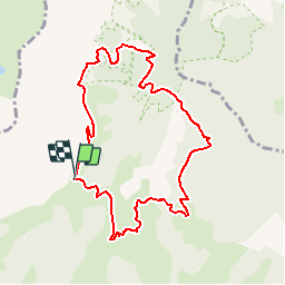
![](/images/other/stat-length.png)
![Excursión Senderismo Ugine - Balade dans le Val d'Arly - Le Praz Vechin - Photo](https://media.geolcdn.com/t/1900/400/ext.pjpeg?maxdim=2&url=https%3A%2F%2Fservices.sitytrail.com%2FGeolivesWS%2FDownloadMedia.ashx%3FTrailID%3D108783%26Media%3D1950_6.jpg)
Balade dans le Val d'Arly - Le Praz Vechin
tracegps
Usuario
![Longitud](/images/other/stat-length.png)
![Altitud máxima](https://static1.geolcdn.com/siteimages/upload/files/1508320355ic_sort_altitude_max_24dp.png)
![Desnivel positivo](https://static1.geolcdn.com/siteimages/upload/files/1508320355ic_sort_den_pos_24dp.png)
![Km-Effort](/images/other/stat-length.png)
![Altitud mínima](https://static1.geolcdn.com/siteimages/upload/files/1508320355ic_sort_altitude_min_24dp.png)
![Desnivel negativo](https://static1.geolcdn.com/siteimages/upload/files/1508320355ic_sort_den_neg_24dp.png)
![Boucle](https://static1.geolcdn.com/siteimages/upload/files/16400158638029165_repeat_loop_refresh_sync_direction_icon.png)
![Senderismo](https://static1.geolcdn.com/sitytour/trail-icons/101.png)
4h00
Dificultad : Difícil
![Escanee este código QR para abrir la excursión en la aplicación SityTrail](https://capi.geolives.com/qq0zvz2zws4bq2lad0pu/sitytour/trails/108783/qr.png?size=200)
Aplicación GPS de excursión GRATIS
A propósito
Ruta Senderismo de 9 km a descubrir en Auvergne-Rhône-Alpes, Saboya, Ugine. Esta ruta ha sido propuesta por tracegps.
Descripción
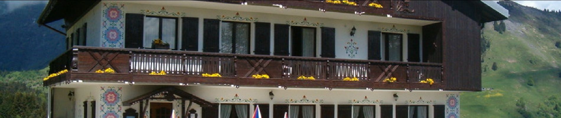
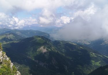
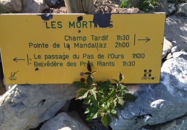
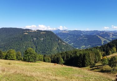
Le sommet de Praz-Vechin (1743m) se trouve dans la partie occidentale du massif des Aravis, au dessus du val d'Arly. C'est une très belle randonnée, en versant sud, en alpages et forêt, dans un secteur injustement méconnu, aboutissant à un véritable sommet. Le point de départ est proche d'Albertville et facile d'accès. Les nombreux chalets des alentours accentuent l'ambiance "Haute-Savoie", bien que l'on soit encore en Savoie. L'itinéraire se déroule au pied de l'impressionnant Charvin (2409m), face aux massifs du Mont-Blanc et du Beaufortain. Le panorama est déjà superbe tout au long de la montée. On découvre alors la chaîne des Aravis, le Val d'Arly, Megève, les aiguilles de Chamonix et les aiguilles Rouges. Accès voiture : Depuis Ugine prendre la D 109 en direction d’Héry. Avant d’entrer dans ce village, prendre la première route à gauche « Route des Montagnes » et la suivre jusqu’au col de l’Arpettaz. Point de départ : Parking du col de l’Arpettaz. Altitude départ : 1581 m Altitude point culminant : 1743 m Dénivelée positive : 522 m Le Praz Vechin Ce circuit offre des plaisirs variés. Du sommet de Praz Vechin un panorama exceptionnel sur la chaîne du Mont-Blanc et la possibilité de rencontrer sur votre passage : petits tétras, marmottes, chamois, mouflons. Itinéraire : Du col de l’Arpettaz reprendre la route des montagnes sue 1,5 km. Quitter la piste au lieu-dit Retorney (1518 m) pour gravir le Mont Praz-Vechin. Au sommet (1743 m) une table d’orientation décrit le panorama. Redescente en direction des ruines des chalets de Belleuvre (1486 m – point d’eau) et passage en forêt du bois des Fugiers à la Frachette , au Plan du Tour (1286 m). Après avoir traversé le ravin de la Gouerallaz (1284 m) remonter pour arriver dans l’alpage de la Petite Giettaz (1410m – abri refuge – point d’eau). A travers bois et près le chemin rejoint la Route des Montagnes aux Chappes. Suivre la piste sur 5 km pour arriver au parking du point de départ.
Localización
Comentarios
Excursiones cerca
![Excursión Esquí de fondo Le Bouchet-Mont-Charvin - Dôme de Pouilly et col de Tulle - Photo](https://media.geolcdn.com/t/375/260/6097fab6-ccc8-4f3a-9796-0f50c13df02e.jpg&format=jpg&maxdim=2)
![Esquí de fondo Esquí de fondo](https://static1.geolcdn.com/sitytour/trail-icons/503.png)
Esquí de fondo
![](/images/other/stat-length.png)
![](https://static1.geolcdn.com/siteimages/upload/files/16400158638029165_repeat_loop_refresh_sync_direction_icon.png)
![Excursión Senderismo Ugine - la Gouenne, la rouelle, la tête de l'aupt - Photo](https://media.geolcdn.com/t/375/260/b7aa1ad4-f9aa-4cdb-891a-e6b93298db71.jpg&format=jpg&maxdim=2)
![Senderismo Senderismo](https://static1.geolcdn.com/sitytour/trail-icons/101.png)
Senderismo
![](/images/other/stat-length.png)
![](https://static1.geolcdn.com/siteimages/upload/files/16400158638029165_repeat_loop_refresh_sync_direction_icon.png)
![Excursión Senderismo Le Bouchet-Mont-Charvin - Lac Charvin - Photo](https://media.geolcdn.com/t/375/260/ext.jpg?maxdim=2&url=https%3A%2F%2Fstatic1.geolcdn.com%2Fsiteimages%2Fupload%2Ffiles%2F1553511878bg_sport_marche.png)
![Senderismo Senderismo](https://static1.geolcdn.com/sitytour/trail-icons/101.png)
Senderismo
![](/images/other/stat-length.png)
![](https://static1.geolcdn.com/siteimages/upload/files/16400158638029165_repeat_loop_refresh_sync_direction_icon.png)
![Excursión Senderismo Saint-Nicolas-la-Chapelle - SAINT NICOLAS LA CHAPELLE - Photo](https://media.geolcdn.com/t/375/260/ext.jpg?maxdim=2&url=https%3A%2F%2Fstatic1.geolcdn.com%2Fsiteimages%2Fupload%2Ffiles%2F1553511878bg_sport_marche.png)
![Senderismo Senderismo](https://static1.geolcdn.com/sitytour/trail-icons/101.png)
Senderismo
![](/images/other/stat-length.png)
![](https://static1.geolcdn.com/siteimages/upload/files/16400158638029165_repeat_loop_refresh_sync_direction_icon.png)
![Excursión Raquetas de nieve Ugine - Hery - Belieuvre - Photo](https://media.geolcdn.com/t/375/260/7701b265-79d1-465c-b1a6-cf07332fb46a.jpg&format=jpg&maxdim=2)
![Raquetas de nieve Raquetas de nieve](https://static1.geolcdn.com/sitytour/trail-icons/504.png)
Raquetas de nieve
![](/images/other/stat-length.png)
![](https://static1.geolcdn.com/siteimages/upload/files/16400158638029165_repeat_loop_refresh_sync_direction_icon.png)
![Excursión Senderismo Manigod - Lac Charvin - Photo](https://media.geolcdn.com/t/375/260/1d1f35e5-6edb-4345-b537-18bf9791b28b.jpg&format=jpg&maxdim=2)
![Senderismo Senderismo](https://static1.geolcdn.com/sitytour/trail-icons/101.png)
Senderismo
![](/images/other/stat-length.png)
![](https://static1.geolcdn.com/siteimages/upload/files/16400158638029165_repeat_loop_refresh_sync_direction_icon.png)
![Excursión Vía ferrata Ugine - 73 Charvin arête sud 01:07:21 - Photo](https://media.geolcdn.com/t/375/260/859bb956-548e-4a99-91ff-8d759d7c0217.jpg&format=jpg&maxdim=2)
![Vía ferrata Vía ferrata](https://static1.geolcdn.com/sitytour/trail-icons/902.png)
Vía ferrata
![](/images/other/stat-length.png)
![](https://static1.geolcdn.com/siteimages/upload/files/16400158638029165_repeat_loop_refresh_sync_direction_icon.png)
![Excursión Senderismo Saint-Nicolas-la-Chapelle - tour par croix cartier depuis Nanchard - Photo](https://media.geolcdn.com/t/375/260/ext.jpg?maxdim=2&url=https%3A%2F%2Fservices.sitytrail.com%2FGeolivesWS%2FDownloadMedia.ashx%3FTrailID%3D1036438%26Media%3Dfix__20180908153210.jpg)
![Senderismo Senderismo](https://static1.geolcdn.com/sitytour/trail-icons/101.png)
Senderismo
![](/images/other/stat-length.png)
![](https://static1.geolcdn.com/siteimages/upload/files/16400158638029165_repeat_loop_refresh_sync_direction_icon.png)
![Excursión Senderismo Ugine - Praz Véchin - Photo](https://media.geolcdn.com/t/375/260/ext.jpg?maxdim=2&url=https%3A%2F%2Fstatic1.geolcdn.com%2Fsiteimages%2Fupload%2Ffiles%2F1553511878bg_sport_marche.png)
![Senderismo Senderismo](https://static1.geolcdn.com/sitytour/trail-icons/101.png)
Senderismo
![](/images/other/stat-length.png)
![](https://static1.geolcdn.com/siteimages/upload/files/16400158638029165_repeat_loop_refresh_sync_direction_icon.png)