![](/images/other/stat-length.png)
![Excursión Caballo Saint-Méloir-des-Ondes - Dinan - Mont Saint Michel 3 - Photo](https://media.geolcdn.com/t/1900/400/ext.pjpeg?maxdim=2&url=https%3A%2F%2Fservices.sitytrail.com%2FGeolivesWS%2FDownloadMedia.ashx%3FTrailID%3D108639%26Media%3D1551_1.jpg)
Dinan - Mont Saint Michel 3
tracegps
Usuario
![Longitud](/images/other/stat-length.png)
![Altitud máxima](https://static1.geolcdn.com/siteimages/upload/files/1508320355ic_sort_altitude_max_24dp.png)
![Desnivel positivo](https://static1.geolcdn.com/siteimages/upload/files/1508320355ic_sort_den_pos_24dp.png)
![Km-Effort](/images/other/stat-length.png)
![Altitud mínima](https://static1.geolcdn.com/siteimages/upload/files/1508320355ic_sort_altitude_min_24dp.png)
![Desnivel negativo](https://static1.geolcdn.com/siteimages/upload/files/1508320355ic_sort_den_neg_24dp.png)
![Boucle](https://static1.geolcdn.com/siteimages/upload/files/16400158638029165_repeat_loop_refresh_sync_direction_icon.png)
![Caballo](https://static1.geolcdn.com/sitytour/trail-icons/300.png)
6h00
Dificultad : Muy difícil
![Escanee este código QR para abrir la excursión en la aplicación SityTrail](https://capi.geolives.com/qq0zvz2zws4bq2lad0pu/sitytour/trails/108639/qr.png?size=200)
Aplicación GPS de excursión GRATIS
A propósito
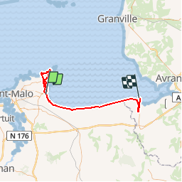
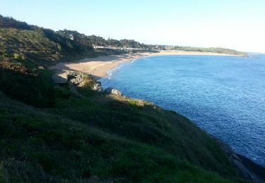
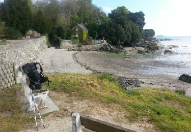
Ruta Caballo de 57 km a descubrir en Bretaña, Ille-et-Vilaine, Saint-Méloir-des-Ondes. Esta ruta ha sido propuesta por tracegps.
Descripción
Troisième étape... Balade présentée par l’Association des Amis du Cheval d'Ille et Vilaine D’autres informations sont disponibles sur le site de l’Equibreizh L’utilisation de ce tracé reste de la responsabilité des randonneurs équestres, c'est-à-dire qu'il appartient à ceux-ci de vérifier qu'au moment de leur utilisation, les circuits sont toujours corrects même si nous veillons à ce qu'ils le soient en permanence, et de plus notre responsabilité ne serait pas engagée si l'un des circuits était non praticable ou bouché, ou si l'utilisation était différente de celle que nous avons validée, à savoir équestre.
Localización
Comentarios
Excursiones cerca
![Excursión A pie Cancale - Balade rapide à Cancale (hors groupe) - Photo](https://media.geolcdn.com/t/375/260/8cca7f8b-f64f-48e7-9459-b60c481745c3.jpg&format=jpg&maxdim=2)
![A pie A pie](https://static1.geolcdn.com/sitytour/trail-icons/100.png)
A pie
![](/images/other/stat-length.png)
![](https://static1.geolcdn.com/siteimages/upload/files/16400158638029165_repeat_loop_refresh_sync_direction_icon.png)
![Excursión Senderismo Cancale - cancale rue rimains pointe grouin 13km 300+- 3h45 - Photo](https://media.geolcdn.com/t/375/260/89383826-80ea-4b16-9008-76db6007cc91.jpg&format=jpg&maxdim=2)
![Senderismo Senderismo](https://static1.geolcdn.com/sitytour/trail-icons/101.png)
Senderismo
![](/images/other/stat-length.png)
![](https://static1.geolcdn.com/siteimages/upload/files/16400158638029165_repeat_loop_refresh_sync_direction_icon.png)
![Excursión Senderismo Cancale - Étape N°12 Cancale Dol-de-Bretagne - Photo](https://media.geolcdn.com/t/375/260/2c5f18a5-022a-4564-9d3f-adfeb68668ac.jpg&format=jpg&maxdim=2)
![Senderismo Senderismo](https://static1.geolcdn.com/sitytour/trail-icons/101.png)
Senderismo
![](/images/other/stat-length.png)
![](https://static1.geolcdn.com/siteimages/upload/files/16400158638029165_repeat_loop_refresh_sync_direction_icon.png)
![Excursión Senderismo Saint-Méloir-des-Ondes - de st meloir des ondes jusqu'à Cancale par la côte - Photo](https://media.geolcdn.com/t/375/260/18ba2e52-98b1-48f0-b3c4-b5475afe7c5d.jpg&format=jpg&maxdim=2)
![Senderismo Senderismo](https://static1.geolcdn.com/sitytour/trail-icons/101.png)
Senderismo
![](/images/other/stat-length.png)
![](https://static1.geolcdn.com/siteimages/upload/files/16400158638029165_repeat_loop_refresh_sync_direction_icon.png)
![Excursión Senderismo Saint-Coulomb - GR 34 étape 9 - Photo](https://media.geolcdn.com/t/375/260/ext.jpg?maxdim=2&url=https%3A%2F%2Fservices.sitytrail.com%2FGeolivesWS%2FDownloadMedia.ashx%3FTrailID%3D271031%26Media%3Dfix__20140415085838.jpg)
![Senderismo Senderismo](https://static1.geolcdn.com/sitytour/trail-icons/101.png)
Senderismo
![](/images/other/stat-length.png)
![](https://static1.geolcdn.com/siteimages/upload/files/16400158638029165_repeat_loop_refresh_sync_direction_icon.png)
![Excursión Senderismo Saint-Benoît-des-Ondes - GR 34 étape 8 - Photo](https://media.geolcdn.com/t/375/260/ext.jpg?maxdim=2&url=https%3A%2F%2Fservices.sitytrail.com%2FGeolivesWS%2FDownloadMedia.ashx%3FTrailID%3D271026%26Media%3Dfix__20140414102130.jpg)
![Senderismo Senderismo](https://static1.geolcdn.com/sitytour/trail-icons/101.png)
Senderismo
![](/images/other/stat-length.png)
![](https://static1.geolcdn.com/siteimages/upload/files/16400158638029165_repeat_loop_refresh_sync_direction_icon.png)
![Excursión Senderismo Cancale - gr 34 cancale-anse du Guesclin - Photo](https://media.geolcdn.com/t/375/260/ext.jpg?maxdim=2&url=https%3A%2F%2Fservices.sitytrail.com%2FGeolivesWS%2FDownloadMedia.ashx%3FTrailID%3D228350%26Media%3Dfix__20131021170609.jpg)
![Senderismo Senderismo](https://static1.geolcdn.com/sitytour/trail-icons/101.png)
Senderismo
![](/images/other/stat-length.png)
![](https://static1.geolcdn.com/siteimages/upload/files/16400158638029165_repeat_loop_refresh_sync_direction_icon.png)
![Excursión Senderismo Cancale - cancale, pointe du Nid, Port Mer - Photo](https://media.geolcdn.com/t/375/260/9f4b1342-89b6-4451-84ae-33cc7a19ec4f.jpg&format=jpg&maxdim=2)
![Senderismo Senderismo](https://static1.geolcdn.com/sitytour/trail-icons/101.png)
Senderismo
![](/images/other/stat-length.png)
![](https://static1.geolcdn.com/siteimages/upload/files/16400158638029165_repeat_loop_refresh_sync_direction_icon.png)
![Excursión Senderismo Cancale - basse cancale - Photo](https://media.geolcdn.com/t/375/260/8fa34fa0-71bf-4a02-bd59-42558d571e1a.jpg&format=jpg&maxdim=2)
![Senderismo Senderismo](https://static1.geolcdn.com/sitytour/trail-icons/101.png)
Senderismo
![](/images/other/stat-length.png)
![](https://static1.geolcdn.com/siteimages/upload/files/16400158638029165_repeat_loop_refresh_sync_direction_icon.png)