![](/images/other/stat-length.png)
![Excursión Senderismo Parfondeval - Par le fond du val - Photo](https://media.geolcdn.com/t/1900/400/ext.pjpeg?maxdim=2&url=https%3A%2F%2Fservices.sitytrail.com%2FGeolivesWS%2FDownloadMedia.ashx%3FTrailID%3D108375%26Media%3D1059_2.jpg)
Par le fond du val
tracegps
Usuario
![Longitud](/images/other/stat-length.png)
Longitud
13 km
![Altitud máxima](https://static1.geolcdn.com/siteimages/upload/files/1508320355ic_sort_altitude_max_24dp.png)
Altitud máxima
245 m
![Desnivel positivo](https://static1.geolcdn.com/siteimages/upload/files/1508320355ic_sort_den_pos_24dp.png)
Desnivel positivo
143 m
![Km-Effort](/images/other/stat-length.png)
Km-Effort
14,9 km
![Altitud mínima](https://static1.geolcdn.com/siteimages/upload/files/1508320355ic_sort_altitude_min_24dp.png)
Altitud mínima
173 m
![Desnivel negativo](https://static1.geolcdn.com/siteimages/upload/files/1508320355ic_sort_den_neg_24dp.png)
Desnivel negativo
143 m
![Boucle](https://static1.geolcdn.com/siteimages/upload/files/16400158638029165_repeat_loop_refresh_sync_direction_icon.png)
Boucle
Sí
Fecha de creación :
2014-12-10 00:00:00.0
Última modificación :
2014-12-10 00:00:00.0
![Senderismo](https://static1.geolcdn.com/sitytour/trail-icons/101.png)
3h30
Dificultad : Muy difícil
![Escanee este código QR para abrir la excursión en la aplicación SityTrail](https://capi.geolives.com/qq0zvz2zws4bq2lad0pu/sitytour/trails/108375/qr.png?size=200)
Aplicación GPS de excursión GRATIS
A propósito
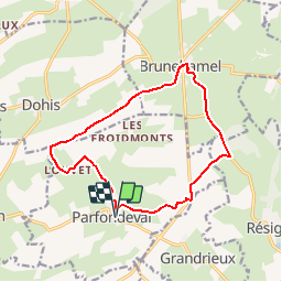
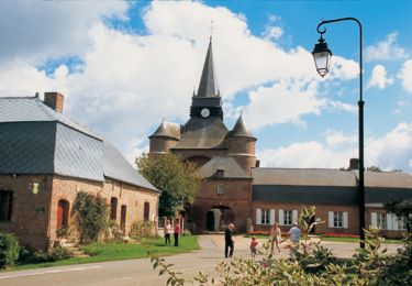
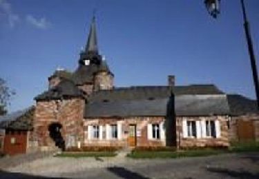
Ruta Senderismo de 13 km a descubrir en Alta Francia, Aisne, Parfondeval. Esta ruta ha sido propuesta por tracegps.
Descripción
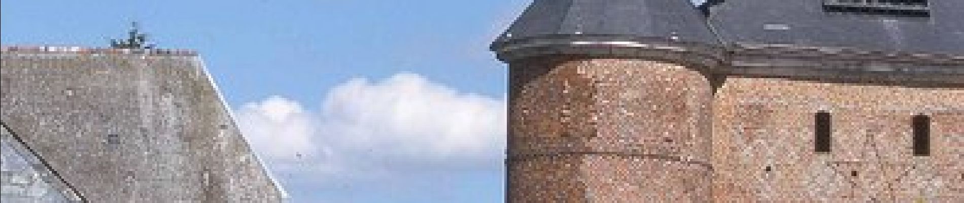
Classé parmi les "plus beaux villages de France", Parfondeval, avec son église fortifiée dominant la Brune et ses maisons de brique ou à colombages, est le point de départ de ce parcours entre vergers de pommiers et petits bois de feuillus. Toutes les infos sont ICI
Localización
País:
France
Región :
Alta Francia
Departamento/provincia :
Aisne
Municipio :
Parfondeval
Localidad:
Unknown
Salida:(Dec)
Salida:(UTM)
583576 ; 5510314 (31U) N.
Comentarios
Excursiones cerca
![Excursión A pie Brunehamel - Par le fond du val - Photo](https://media.geolcdn.com/t/375/260/8e3a953d-955c-4c62-a89d-391f5e526a72.jpeg&format=jpg&maxdim=2)
![A pie A pie](https://static1.geolcdn.com/sitytour/trail-icons/100.png)
Par le fond du val
A pie
Fácil
Brunehamel,
Alta Francia,
Aisne,
France
![](/images/other/stat-length.png)
12,5 km | 14,2 km-effort
3h 14min
![](https://static1.geolcdn.com/siteimages/upload/files/16400158638029165_repeat_loop_refresh_sync_direction_icon.png)
Sí
![Excursión Senderismo Brunehamel - 2023_04_23 PARFONDEVAL - Photo](https://media.geolcdn.com/t/375/260/376aed58-e901-440d-acd2-8ccf990f5b65.jpg&format=jpg&maxdim=2)
![Senderismo Senderismo](https://static1.geolcdn.com/sitytour/trail-icons/101.png)
2023_04_23 PARFONDEVAL
Senderismo
Difícil
Brunehamel,
Alta Francia,
Aisne,
France
![](/images/other/stat-length.png)
10,5 km | 12,4 km-effort
2h 49min
![](https://static1.geolcdn.com/siteimages/upload/files/16400158638029165_repeat_loop_refresh_sync_direction_icon.png)
No
![Excursión Senderismo Parfondeval - Le chemin de la brique et du torchis - Photo](https://media.geolcdn.com/t/375/260/ext.jpg?maxdim=2&url=https%3A%2F%2Fservices.sitytrail.com%2FGeolivesWS%2FDownloadMedia.ashx%3FTrailID%3D108963%26Media%3D2852_1.jpg)
![Senderismo Senderismo](https://static1.geolcdn.com/sitytour/trail-icons/101.png)
Le chemin de la brique et du torchis
Senderismo
Fácil
Parfondeval,
Alta Francia,
Aisne,
France
![](/images/other/stat-length.png)
1,4 km | 1,7 km-effort
45min
![](https://static1.geolcdn.com/siteimages/upload/files/16400158638029165_repeat_loop_refresh_sync_direction_icon.png)
Sí
![Excursión Senderismo Résigny - Du chemin de fer au chemin vert - Photo](https://media.geolcdn.com/t/375/260/ext.jpg?maxdim=2&url=https%3A%2F%2Fstatic1.geolcdn.com%2Fsiteimages%2Fupload%2Ffiles%2F1553511878bg_sport_marche.png)
![Senderismo Senderismo](https://static1.geolcdn.com/sitytour/trail-icons/101.png)
Du chemin de fer au chemin vert
Senderismo
Medio
Résigny,
Alta Francia,
Aisne,
France
![](/images/other/stat-length.png)
7,6 km | 9,2 km-effort
2h 30min
![](https://static1.geolcdn.com/siteimages/upload/files/16400158638029165_repeat_loop_refresh_sync_direction_icon.png)
Sí
![Excursión Senderismo Parfondeval - Le chemin de la brique et du torchis - Photo](https://media.geolcdn.com/t/375/260/ext.jpg?maxdim=2&url=https%3A%2F%2Fservices.sitytrail.com%2FGeolivesWS%2FDownloadMedia.ashx%3FTrailID%3D202835%26Media%3D55446afe-e8cc-4c8a-9dd2-8ae97c09a375.jpg)
![Senderismo Senderismo](https://static1.geolcdn.com/sitytour/trail-icons/101.png)
Le chemin de la brique et du torchis
Senderismo
Muy fácil
Parfondeval,
Alta Francia,
Aisne,
France
![](/images/other/stat-length.png)
1,4 km | 1,7 km-effort
Desconocido
![](https://static1.geolcdn.com/siteimages/upload/files/16400158638029165_repeat_loop_refresh_sync_direction_icon.png)
Sí