![](/images/other/stat-length.png)
![Excursión Carrera Noyers-sur-Jabron - Boucle Vieux Noyers - Chapelle St Claude - Photo](https://media.geolcdn.com/t/1900/400/ext.pjpeg?maxdim=2&url=https%3A%2F%2Fservices.sitytrail.com%2FGeolivesWS%2FDownloadMedia.ashx%3FTrailID%3D107724%26Media%3D12768_1.jpg)
Boucle Vieux Noyers - Chapelle St Claude
tracegps
Usuario
![Longitud](/images/other/stat-length.png)
![Altitud máxima](https://static1.geolcdn.com/siteimages/upload/files/1508320355ic_sort_altitude_max_24dp.png)
![Desnivel positivo](https://static1.geolcdn.com/siteimages/upload/files/1508320355ic_sort_den_pos_24dp.png)
![Km-Effort](/images/other/stat-length.png)
![Altitud mínima](https://static1.geolcdn.com/siteimages/upload/files/1508320355ic_sort_altitude_min_24dp.png)
![Desnivel negativo](https://static1.geolcdn.com/siteimages/upload/files/1508320355ic_sort_den_neg_24dp.png)
![Boucle](https://static1.geolcdn.com/siteimages/upload/files/16400158638029165_repeat_loop_refresh_sync_direction_icon.png)
![Carrera](https://static1.geolcdn.com/sitytour/trail-icons/103.png)
1h19
Dificultad : Medio
![Escanee este código QR para abrir la excursión en la aplicación SityTrail](https://capi.geolives.com/qq0zvz2zws4bq2lad0pu/sitytour/trails/107724/qr.png?size=200)
Aplicación GPS de excursión GRATIS
A propósito
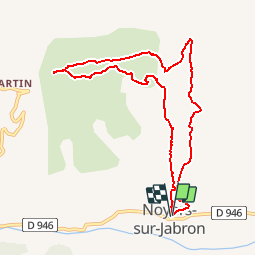
Ruta Carrera de 9,3 km a descubrir en Provenza-Alpes-Costa Azul, Alpes de Alta Provenza, Noyers-sur-Jabron. Esta ruta ha sido propuesta por tracegps.
Descripción
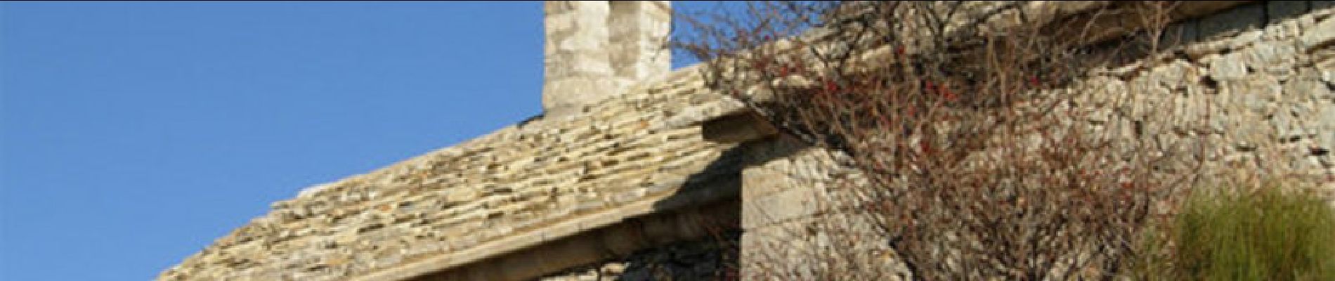
Départ derrière la mairie. Prendre la route du Vieux Noyers jusqu'au croisement de Durban. Suivre Durban. Puis prendre le GR6 jusqu'au Vieux Noyers. Traverser le village. A la sortie prendre le sentier qui vous mènera jusqu'à la Chapelle St Claude.
Localización
Comentarios
Excursiones cerca
![Excursión Senderismo Valbelle - VALBELLE . Chemin de Sara o l s - Photo](https://media.geolcdn.com/t/375/260/f5bc0f94-fea9-4cf8-899a-951c04f93f5f.jpg&format=jpg&maxdim=2)
![Senderismo Senderismo](https://static1.geolcdn.com/sitytour/trail-icons/101.png)
Senderismo
![](/images/other/stat-length.png)
![](https://static1.geolcdn.com/siteimages/upload/files/16400158638029165_repeat_loop_refresh_sync_direction_icon.png)
![Excursión Senderismo Valbelle - 05 chap st Pons col sumiou zel - Photo](https://media.geolcdn.com/t/375/260/654eadec-c68c-403c-8c9b-a622285d41ca.jpg&format=jpg&maxdim=2)
![Senderismo Senderismo](https://static1.geolcdn.com/sitytour/trail-icons/101.png)
Senderismo
![](/images/other/stat-length.png)
![](https://static1.geolcdn.com/siteimages/upload/files/16400158638029165_repeat_loop_refresh_sync_direction_icon.png)
![Excursión Senderismo Valbelle - chapelle saint Pont et montagne Sumiou - Photo](https://media.geolcdn.com/t/375/260/36d6cde7-c446-427e-9ab1-73d7e5890674.jpg&format=jpg&maxdim=2)
![Senderismo Senderismo](https://static1.geolcdn.com/sitytour/trail-icons/101.png)
Senderismo
![](/images/other/stat-length.png)
![](https://static1.geolcdn.com/siteimages/upload/files/16400158638029165_repeat_loop_refresh_sync_direction_icon.png)
![Excursión A pie Noyers-sur-Jabron - Montagne de Sumiou - Grotte des Peyrouets_19_01_2024 - Photo](https://media.geolcdn.com/t/375/260/d885e4ac-abdf-4f73-b427-5e5b97ac821b.jpg&format=jpg&maxdim=2)
![A pie A pie](https://static1.geolcdn.com/sitytour/trail-icons/100.png)
A pie
![](/images/other/stat-length.png)
![](https://static1.geolcdn.com/siteimages/upload/files/16400158638029165_repeat_loop_refresh_sync_direction_icon.png)
![Excursión Senderismo Valbelle - 04 chapelle St Pons 03.08.23 - Photo](https://media.geolcdn.com/t/375/260/a22dc00e-ca36-48e1-a26c-c25718a9238f.jpg&format=jpg&maxdim=2)
![Senderismo Senderismo](https://static1.geolcdn.com/sitytour/trail-icons/101.png)
Senderismo
![](/images/other/stat-length.png)
![](https://static1.geolcdn.com/siteimages/upload/files/16400158638029165_repeat_loop_refresh_sync_direction_icon.png)
![Excursión Senderismo Val-Buëch-Méouge - Rocher de pierre Impie, roc de l'aigle, pas de Berches - Photo](https://media.geolcdn.com/t/375/260/872433af-29da-42c0-940a-93266e0778d4.jpg&format=jpg&maxdim=2)
![Senderismo Senderismo](https://static1.geolcdn.com/sitytour/trail-icons/101.png)
Senderismo
![](/images/other/stat-length.png)
![](https://static1.geolcdn.com/siteimages/upload/files/16400158638029165_repeat_loop_refresh_sync_direction_icon.png)
![Excursión Senderismo Noyers-sur-Jabron - SityTrail - NOYERS SUR JABRON , S Martin , col S Pierre , cretes de l ane n - Photo](https://media.geolcdn.com/t/375/260/b5b69900-a4cf-40a0-8395-e0fe0112d265.jpg&format=jpg&maxdim=2)
![Senderismo Senderismo](https://static1.geolcdn.com/sitytour/trail-icons/101.png)
Senderismo
![](/images/other/stat-length.png)
![](https://static1.geolcdn.com/siteimages/upload/files/16400158638029165_repeat_loop_refresh_sync_direction_icon.png)
![Excursión A pie Valbelle - Montagne de Lure - Photo](https://media.geolcdn.com/t/375/260/d2f7e93b-ac8d-4890-bbc4-c62d8ad565bf.jpg&format=jpg&maxdim=2)
![A pie A pie](https://static1.geolcdn.com/sitytour/trail-icons/100.png)
A pie
![](/images/other/stat-length.png)
![](https://static1.geolcdn.com/siteimages/upload/files/16400158638029165_repeat_loop_refresh_sync_direction_icon.png)
![Excursión Senderismo Valbelle - Tour de Sumiou - Photo](https://media.geolcdn.com/t/375/260/98046d43-9799-41dd-91ec-957f42022344.jpg&format=jpg&maxdim=2)
![Senderismo Senderismo](https://static1.geolcdn.com/sitytour/trail-icons/101.png)
Senderismo
![](/images/other/stat-length.png)
![](https://static1.geolcdn.com/siteimages/upload/files/16400158638029165_repeat_loop_refresh_sync_direction_icon.png)