![](/images/other/stat-length.png)
![Excursión Bici de montaña Pernes-les-Fontaines - Boucle VTT à Pernes les Fontaines - Photo](https://media.geolcdn.com/t/1900/400/ext.pjpeg?maxdim=2&url=https%3A%2F%2Fservices.sitytrail.com%2FGeolivesWS%2FDownloadMedia.ashx%3FTrailID%3D107723%26Media%3D12766_1.jpg)
Boucle VTT à Pernes les Fontaines
tracegps
Usuario
![Longitud](/images/other/stat-length.png)
![Altitud máxima](https://static1.geolcdn.com/siteimages/upload/files/1508320355ic_sort_altitude_max_24dp.png)
![Desnivel positivo](https://static1.geolcdn.com/siteimages/upload/files/1508320355ic_sort_den_pos_24dp.png)
![Km-Effort](/images/other/stat-length.png)
![Altitud mínima](https://static1.geolcdn.com/siteimages/upload/files/1508320355ic_sort_altitude_min_24dp.png)
![Desnivel negativo](https://static1.geolcdn.com/siteimages/upload/files/1508320355ic_sort_den_neg_24dp.png)
![Boucle](https://static1.geolcdn.com/siteimages/upload/files/16400158638029165_repeat_loop_refresh_sync_direction_icon.png)
![Bici de montaña](https://static1.geolcdn.com/sitytour/trail-icons/202.png)
2h00
Dificultad : Medio
![Escanee este código QR para abrir la excursión en la aplicación SityTrail](https://capi.geolives.com/qq0zvz2zws4bq2lad0pu/sitytour/trails/107723/qr.png?size=200)
Aplicación GPS de excursión GRATIS
A propósito
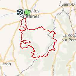
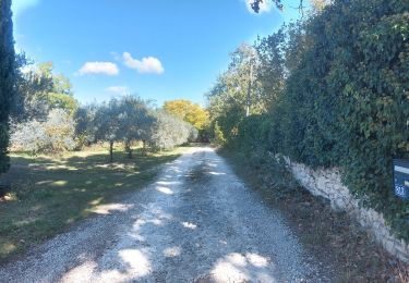
Ruta Bici de montaña de 19,5 km a descubrir en Provenza-Alpes-Costa Azul, Vaucluse, Pernes-les-Fontaines. Esta ruta ha sido propuesta por tracegps.
Descripción
Parcours en boucle qui emprunte en partie des sentiers balisés par le club de vtt local dans les collines proches du moto-cross, bien connues des vététistes. Départ du parking du cimetière de Pernes pour rejoindre le canal, histoire de s'échauffer un peu pendant 2km avant de bifurquer à gauche pour grimper par un chemin caillouteux. Une petite route goudronnée vous mènera au moto-cross avant d'attaquer une partie en monotrace, puis alternance de chemins caillouteux, monotraces en sous-bois, pistes DFCI qui peuvent être interdites en période estivale. Quelques panoramas de temps en temps, plusieurs sentiers par moment, prenez le bon !! Le parcours se termine par un single en légère descente en forêt de 700m de long que j'adore qui slalome entre les arbres et des petits rochers, quelques coups de pédales pour relancer de temps en temps, puis petite route goudronnée à travers les lotissements pour rejoindre tranquillement l'arrivée. Parcours de niveau moyen, quelques descentes un peu techniques, s'adresse à des pratiquants réguliers. Bonne rando.
Localización
Comentarios
Excursiones cerca
![Excursión Senderismo Pernes-les-Fontaines - Pernes les Fontaines - Photo](https://media.geolcdn.com/t/375/260/ext.jpg?maxdim=2&url=https%3A%2F%2Fstatic1.geolcdn.com%2Fsiteimages%2Fupload%2Ffiles%2F1553511878bg_sport_marche.png)
![Senderismo Senderismo](https://static1.geolcdn.com/sitytour/trail-icons/101.png)
Senderismo
![](/images/other/stat-length.png)
![](https://static1.geolcdn.com/siteimages/upload/files/16400158638029165_repeat_loop_refresh_sync_direction_icon.png)
![Excursión Senderismo Velleron - les Arrayes pernes les fontzine - Photo](https://media.geolcdn.com/t/375/260/3cbf6432-1ded-4b5f-8c46-f9282d408bcb.jpg&format=jpg&maxdim=2)
![Senderismo Senderismo](https://static1.geolcdn.com/sitytour/trail-icons/101.png)
Senderismo
![](/images/other/stat-length.png)
![](https://static1.geolcdn.com/siteimages/upload/files/16400158638029165_repeat_loop_refresh_sync_direction_icon.png)
![Excursión Senderismo La Roque-sur-Pernes - La Roque sur Pernes - Photo](https://media.geolcdn.com/t/375/260/b7940c80-53cf-4c29-9015-fcd566f00f03.jpg&format=jpg&maxdim=2)
![Senderismo Senderismo](https://static1.geolcdn.com/sitytour/trail-icons/101.png)
Senderismo
![](/images/other/stat-length.png)
![](https://static1.geolcdn.com/siteimages/upload/files/16400158638029165_repeat_loop_refresh_sync_direction_icon.png)
![Excursión Senderismo Pernes-les-Fontaines - Fontblanque DFCI Font Garnier - Photo](https://media.geolcdn.com/t/375/260/ext.jpg?maxdim=2&url=https%3A%2F%2Fstatic1.geolcdn.com%2Fsiteimages%2Fupload%2Ffiles%2F1553511878bg_sport_marche.png)
![Senderismo Senderismo](https://static1.geolcdn.com/sitytour/trail-icons/101.png)
Senderismo
![](/images/other/stat-length.png)
![](https://static1.geolcdn.com/siteimages/upload/files/16400158638029165_repeat_loop_refresh_sync_direction_icon.png)
![Excursión Senderismo Pernes-les-Fontaines - Pernes Vaucluse lolo - Photo](https://media.geolcdn.com/t/375/260/2f2bb729-c546-437a-820f-662370029749.jpg&format=jpg&maxdim=2)
![Senderismo Senderismo](https://static1.geolcdn.com/sitytour/trail-icons/101.png)
Senderismo
![](/images/other/stat-length.png)
![](https://static1.geolcdn.com/siteimages/upload/files/16400158638029165_repeat_loop_refresh_sync_direction_icon.png)
![Excursión Senderismo Pernes-les-Fontaines - pernes6 - Photo](https://media.geolcdn.com/t/375/260/ext.jpg?maxdim=2&url=https%3A%2F%2Fstatic1.geolcdn.com%2Fsiteimages%2Fupload%2Ffiles%2F1553511878bg_sport_marche.png)
![Senderismo Senderismo](https://static1.geolcdn.com/sitytour/trail-icons/101.png)
Senderismo
![](/images/other/stat-length.png)
![](https://static1.geolcdn.com/siteimages/upload/files/16400158638029165_repeat_loop_refresh_sync_direction_icon.png)
![Excursión Senderismo Pernes-les-Fontaines - Canal de Carpentras Piegros - Photo](https://media.geolcdn.com/t/375/260/78537c5b-cc7e-45a4-9c3b-4eb59be0d966.jpg&format=jpg&maxdim=2)
![Senderismo Senderismo](https://static1.geolcdn.com/sitytour/trail-icons/101.png)
Senderismo
![](/images/other/stat-length.png)
![](https://static1.geolcdn.com/siteimages/upload/files/16400158638029165_repeat_loop_refresh_sync_direction_icon.png)
![Excursión Senderismo La Roque-sur-Pernes - Petite boucle dans les Monts du Vaucluse - Photo](https://media.geolcdn.com/t/375/260/ext.jpg?maxdim=2&url=https%3A%2F%2Fstatic1.geolcdn.com%2Fsiteimages%2Fupload%2Ffiles%2F1553511878bg_sport_marche.png)
![Senderismo Senderismo](https://static1.geolcdn.com/sitytour/trail-icons/101.png)
Senderismo
![](/images/other/stat-length.png)
![](https://static1.geolcdn.com/siteimages/upload/files/16400158638029165_repeat_loop_refresh_sync_direction_icon.png)
![Excursión Otra actividad Pernes-les-Fontaines - pernes les fontaines la roques s pernes - Photo](https://media.geolcdn.com/t/375/260/ext.jpg?maxdim=2&url=https%3A%2F%2Fservices.sitytrail.com%2FGeolivesWS%2FDownloadMedia.ashx%3FTrailID%3D865450%26Media%3D20171121122806.jpg)
![Otra actividad Otra actividad](https://static1.geolcdn.com/sitytour/trail-icons/900.png)
Otra actividad
![](/images/other/stat-length.png)
![](https://static1.geolcdn.com/siteimages/upload/files/16400158638029165_repeat_loop_refresh_sync_direction_icon.png)
Sympa