![](/images/other/stat-length.png)
![Excursión Bici de montaña Trégunc - Boucle Tregunc, Saint Philibert - Photo](https://media.geolcdn.com/t/1900/400/ext.pjpeg?maxdim=2&url=https%3A%2F%2Fstatic1.geolcdn.com%2Fsiteimages%2Fupload%2Ffiles%2F1524743154velo.jpg)
Boucle Tregunc, Saint Philibert
tracegps
Usuario
![Longitud](/images/other/stat-length.png)
Longitud
20 km
![Altitud máxima](https://static1.geolcdn.com/siteimages/upload/files/1508320355ic_sort_altitude_max_24dp.png)
Altitud máxima
39 m
![Desnivel positivo](https://static1.geolcdn.com/siteimages/upload/files/1508320355ic_sort_den_pos_24dp.png)
Desnivel positivo
172 m
![Km-Effort](/images/other/stat-length.png)
Km-Effort
22 km
![Altitud mínima](https://static1.geolcdn.com/siteimages/upload/files/1508320355ic_sort_altitude_min_24dp.png)
Altitud mínima
3 m
![Desnivel negativo](https://static1.geolcdn.com/siteimages/upload/files/1508320355ic_sort_den_neg_24dp.png)
Desnivel negativo
175 m
![Boucle](https://static1.geolcdn.com/siteimages/upload/files/16400158638029165_repeat_loop_refresh_sync_direction_icon.png)
Boucle
Sí
Fecha de creación :
2014-12-10 00:00:00.0
Última modificación :
2014-12-10 00:00:00.0
![Bici de montaña](https://static1.geolcdn.com/sitytour/trail-icons/202.png)
1h30
Dificultad : Medio
![Escanee este código QR para abrir la excursión en la aplicación SityTrail](https://capi.geolives.com/qq0zvz2zws4bq2lad0pu/sitytour/trails/107688/qr.png?size=200)
Aplicación GPS de excursión GRATIS
A propósito
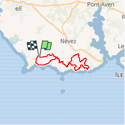
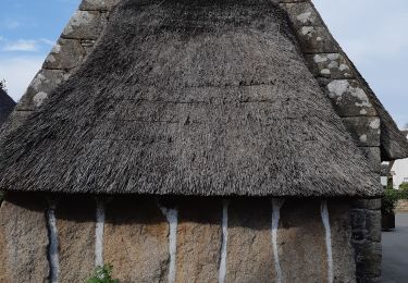
Ruta Bici de montaña de 20 km a descubrir en Bretaña, Finisterre, Trégunc. Esta ruta ha sido propuesta por tracegps.
Descripción
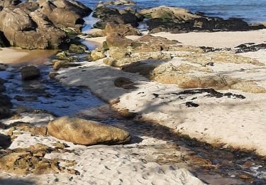
Boucle Tregunc, Saint Philibert. Départ à la chapelle de saint Philibert, entre la boulangerie et la chapelle. Rando sympa sans grande difficulté. L'anse de Rospico, plage de Kersidan à portée de vue...
Localización
País:
France
Región :
Bretaña
Departamento/provincia :
Finisterre
Municipio :
Trégunc
Localidad:
Unknown
Salida:(Dec)
Salida:(UTM)
437659 ; 5295035 (30T) N.
Comentarios
Excursiones cerca
![Excursión Carrera Trégunc - GR34 - 31 - Photo](https://media.geolcdn.com/t/375/260/ext.jpg?maxdim=2&url=https%3A%2F%2Fstatic1.geolcdn.com%2Fsiteimages%2Fupload%2Ffiles%2F1524743154running.jpg)
![Carrera Carrera](https://static1.geolcdn.com/sitytour/trail-icons/103.png)
![Excursión Senderismo Névez - Samedi 4 novembre 2012 - Photo](https://media.geolcdn.com/t/375/260/ext.jpg?maxdim=2&url=https%3A%2F%2Fstatic1.geolcdn.com%2Fsiteimages%2Fupload%2Ffiles%2F1553511878bg_sport_marche.png)
![Senderismo Senderismo](https://static1.geolcdn.com/sitytour/trail-icons/101.png)
Samedi 4 novembre 2012
Senderismo
Muy fácil
(1)
Névez,
Bretaña,
Finisterre,
France
![](/images/other/stat-length.png)
6,6 km | 7,2 km-effort
1h 16min
![](https://static1.geolcdn.com/siteimages/upload/files/16400158638029165_repeat_loop_refresh_sync_direction_icon.png)
Sí
![Excursión Senderismo Trégunc - Randonnee de Trévignon - Trégunc - Photo](https://media.geolcdn.com/t/375/260/ext.jpg?maxdim=2&url=https%3A%2F%2Fstatic1.geolcdn.com%2Fsiteimages%2Fupload%2Ffiles%2F1553511878bg_sport_marche.png)
![Senderismo Senderismo](https://static1.geolcdn.com/sitytour/trail-icons/101.png)
Randonnee de Trévignon - Trégunc
Senderismo
Fácil
(2)
Trégunc,
Bretaña,
Finisterre,
France
![](/images/other/stat-length.png)
6,7 km | 7,3 km-effort
1h 45min
![](https://static1.geolcdn.com/siteimages/upload/files/16400158638029165_repeat_loop_refresh_sync_direction_icon.png)
Sí
![Excursión Senderismo Trégunc - Yregunc re ar wenodenn - Photo](https://media.geolcdn.com/t/375/260/920b2546-d768-4de0-82fe-cbd6fddcfc28.jpg&format=jpg&maxdim=2)
![Senderismo Senderismo](https://static1.geolcdn.com/sitytour/trail-icons/101.png)
Yregunc re ar wenodenn
Senderismo
Fácil
Trégunc,
Bretaña,
Finisterre,
France
![](/images/other/stat-length.png)
5,8 km | 6,2 km-effort
1h 33min
![](https://static1.geolcdn.com/siteimages/upload/files/16400158638029165_repeat_loop_refresh_sync_direction_icon.png)
Sí
![Excursión Senderismo Trégunc - Saint Philibert-Trévignon plage - Photo](https://media.geolcdn.com/t/375/260/cebc81cb-da8e-476d-ba58-36b6f4cdb247.jpg&format=jpg&maxdim=2)
![Senderismo Senderismo](https://static1.geolcdn.com/sitytour/trail-icons/101.png)
Saint Philibert-Trévignon plage
Senderismo
Medio
Trégunc,
Bretaña,
Finisterre,
France
![](/images/other/stat-length.png)
7,1 km | 7,7 km-effort
1h 55min
![](https://static1.geolcdn.com/siteimages/upload/files/16400158638029165_repeat_loop_refresh_sync_direction_icon.png)
Sí
![Excursión Senderismo Trégunc - TREGUNC - Photo](https://media.geolcdn.com/t/375/260/04a90680-2ce4-46fa-965d-80bc63343dd4.jpg&format=jpg&maxdim=2)
![Senderismo Senderismo](https://static1.geolcdn.com/sitytour/trail-icons/101.png)
![Excursión Senderismo Trégunc - Tregunc - Photo](https://media.geolcdn.com/t/375/260/0294ed77-693d-4112-8e2e-97085a77d8cd.jpg&format=jpg&maxdim=2)
![Senderismo Senderismo](https://static1.geolcdn.com/sitytour/trail-icons/101.png)
![Excursión Senderismo Névez - Kerascoët- Plage de Tahiti-Raguenez - Photo](https://media.geolcdn.com/t/375/260/eb9238df-9db1-4408-903e-0787f78f91db.jpg&format=jpg&maxdim=2)
![Senderismo Senderismo](https://static1.geolcdn.com/sitytour/trail-icons/101.png)
Kerascoët- Plage de Tahiti-Raguenez
Senderismo
Muy fácil
Névez,
Bretaña,
Finisterre,
France
![](/images/other/stat-length.png)
3,8 km | 4,3 km-effort
2h 34min
![](https://static1.geolcdn.com/siteimages/upload/files/16400158638029165_repeat_loop_refresh_sync_direction_icon.png)
Sí
![Excursión Senderismo Névez - Rospico, Trémorvézen, Kercvaillet, Plage Tahiti et retour par bord de mer - Photo](https://media.geolcdn.com/t/375/260/ext.jpg?maxdim=2&url=https%3A%2F%2Fstatic1.geolcdn.com%2Fsiteimages%2Fupload%2Ffiles%2F1553511878bg_sport_marche.png)
![Senderismo Senderismo](https://static1.geolcdn.com/sitytour/trail-icons/101.png)
Rospico, Trémorvézen, Kercvaillet, Plage Tahiti et retour par bord de mer
Senderismo
Muy fácil
(1)
Névez,
Bretaña,
Finisterre,
France
![](/images/other/stat-length.png)
7 km | 7,8 km-effort
2h 0min
![](https://static1.geolcdn.com/siteimages/upload/files/16400158638029165_repeat_loop_refresh_sync_direction_icon.png)
Sí