![](/images/other/stat-length.png)
![Excursión Senderismo Lamballe-Armor - Circuit de Frédéric le Grand - Lamballe - Photo](https://media.geolcdn.com/t/1900/400/ext.pjpeg?maxdim=2&url=https%3A%2F%2Fservices.sitytrail.com%2FGeolivesWS%2FDownloadMedia.ashx%3FTrailID%3D107665%26Media%3D12666_2.jpg)
Circuit de Frédéric le Grand - Lamballe
tracegps
Usuario
![Longitud](/images/other/stat-length.png)
![Altitud máxima](https://static1.geolcdn.com/siteimages/upload/files/1508320355ic_sort_altitude_max_24dp.png)
![Desnivel positivo](https://static1.geolcdn.com/siteimages/upload/files/1508320355ic_sort_den_pos_24dp.png)
![Km-Effort](/images/other/stat-length.png)
![Altitud mínima](https://static1.geolcdn.com/siteimages/upload/files/1508320355ic_sort_altitude_min_24dp.png)
![Desnivel negativo](https://static1.geolcdn.com/siteimages/upload/files/1508320355ic_sort_den_neg_24dp.png)
![Boucle](https://static1.geolcdn.com/siteimages/upload/files/16400158638029165_repeat_loop_refresh_sync_direction_icon.png)
![Senderismo](https://static1.geolcdn.com/sitytour/trail-icons/101.png)
2h00
Dificultad : Fácil
![Escanee este código QR para abrir la excursión en la aplicación SityTrail](https://capi.geolives.com/qq0zvz2zws4bq2lad0pu/sitytour/trails/107665/qr.png?size=200)
Aplicación GPS de excursión GRATIS
A propósito
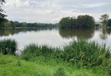
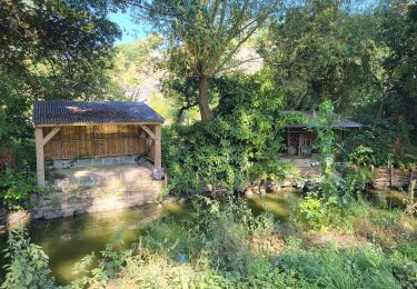
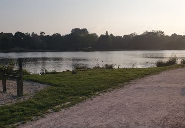
Ruta Senderismo de 2,5 km a descubrir en Bretaña, Côtes-d'Armor, Lamballe-Armor. Esta ruta ha sido propuesta por tracegps.
Descripción
Le nez en l'air et l'œil curieux, découvrez les petits et les mystères de la ville ! "Frédéric", une figure caricaturale qui décore le faîtage de certains toits de Lamballe, sera votre guide. Le circuit mis en place dans la ville se compose d'une vingtaine de panneaux qui présentent l'histoire, l'architecture, les modes de vie à Lamballe... Ils montrent aussi comment la ville s'est développée au cours du temps. C'est une promenade de 2 heures environ. S'y ajoutent des variantes, parfois escarpées, à rejoindre à pied ou en voiture. Les panneaux sont conçus pour être lus indépendamment, comme autant de petites tranches d'histoire, et le parcours peut se faire par petites boucles. Le plan du circuit est disponible à l'Office de Tourisme ou en téléchargement ici. L'Office de Tourisme de Lamballe vous accueille et vous informe sur les sites et monuments de Lamballe et sa région. Vous y trouverez des documents mais aussi toutes les précisions sur les animations, les visites guidées et les bonnes adresses pour déguster Lamballe.
Localización
Comentarios
Excursiones cerca
![Excursión Senderismo Lamballe-Armor - Lamballe - Photo](https://media.geolcdn.com/t/375/260/68057253-fbe0-421e-b139-c42127d16fd7.jpg&format=jpg&maxdim=2)
![Senderismo Senderismo](https://static1.geolcdn.com/sitytour/trail-icons/101.png)
Senderismo
![](/images/other/stat-length.png)
![](https://static1.geolcdn.com/siteimages/upload/files/16400158638029165_repeat_loop_refresh_sync_direction_icon.png)
![Excursión Senderismo Lamballe-Armor - Etape N°06 Lamballe_Pleven - Photo](https://media.geolcdn.com/t/375/260/66e6084e-0313-45e9-b836-18b01efa3a2f.jpg&format=jpg&maxdim=2)
![Senderismo Senderismo](https://static1.geolcdn.com/sitytour/trail-icons/101.png)
Senderismo
![](/images/other/stat-length.png)
![](https://static1.geolcdn.com/siteimages/upload/files/16400158638029165_repeat_loop_refresh_sync_direction_icon.png)
![Excursión Senderismo Lamballe-Armor - 2024-09-29 Lamballe - Photo](https://media.geolcdn.com/t/375/260/ext.jpg?maxdim=2&url=https%3A%2F%2Fstatic1.geolcdn.com%2Fsiteimages%2Fupload%2Ffiles%2F1553511878bg_sport_marche.png)
![Senderismo Senderismo](https://static1.geolcdn.com/sitytour/trail-icons/101.png)
Senderismo
![](/images/other/stat-length.png)
![](https://static1.geolcdn.com/siteimages/upload/files/16400158638029165_repeat_loop_refresh_sync_direction_icon.png)
![Excursión Ruta Lamballe-Armor - plan d'eau 11km - Photo](https://media.geolcdn.com/t/375/260/705c5f18-4105-4b92-b959-9dd4c389b8ac.jpg&format=jpg&maxdim=2)
![Ruta Ruta](https://static1.geolcdn.com/sitytour/trail-icons/104.png)
Ruta
![](/images/other/stat-length.png)
![](https://static1.geolcdn.com/siteimages/upload/files/16400158638029165_repeat_loop_refresh_sync_direction_icon.png)
![Excursión Caravana Lamballe-Armor - camping car 1 liason 2 bretagne guide michelin 2018 - Photo](https://media.geolcdn.com/t/375/260/ext.jpg?maxdim=2&url=https%3A%2F%2Fstatic1.geolcdn.com%2Fsiteimages%2Fupload%2Ffiles%2F15247431544x4.jpg)
![Caravana Caravana](https://static1.geolcdn.com/sitytour/trail-icons/405.png)
Caravana
![](/images/other/stat-length.png)
![](https://static1.geolcdn.com/siteimages/upload/files/16400158638029165_repeat_loop_refresh_sync_direction_icon.png)
![Excursión Bici de montaña Landéhen - landehen rando - Photo](https://media.geolcdn.com/t/375/260/ext.jpg?maxdim=2&url=https%3A%2F%2Fstatic1.geolcdn.com%2Fsiteimages%2Fupload%2Ffiles%2F1524743154velo.jpg)
![Bici de montaña Bici de montaña](https://static1.geolcdn.com/sitytour/trail-icons/202.png)
Bici de montaña
![](/images/other/stat-length.png)
![](https://static1.geolcdn.com/siteimages/upload/files/16400158638029165_repeat_loop_refresh_sync_direction_icon.png)
![Excursión Bici de montaña Lamballe-Armor - De Lamballe à Lancieux par la côte. - Photo](https://media.geolcdn.com/t/375/260/ext.jpg?maxdim=2&url=https%3A%2F%2Fstatic1.geolcdn.com%2Fsiteimages%2Fupload%2Ffiles%2F1524743154velo.jpg)
![Bici de montaña Bici de montaña](https://static1.geolcdn.com/sitytour/trail-icons/202.png)
Bici de montaña
![](/images/other/stat-length.png)
![](https://static1.geolcdn.com/siteimages/upload/files/16400158638029165_repeat_loop_refresh_sync_direction_icon.png)
![Excursión Caballo Lamballe-Armor - Lamballe - Quessoy - Photo](https://media.geolcdn.com/t/375/260/ext.jpg?maxdim=2&url=https%3A%2F%2Fstatic1.geolcdn.com%2Fsiteimages%2Fupload%2Ffiles%2F1524743154cheval.jpg)
![Caballo Caballo](https://static1.geolcdn.com/sitytour/trail-icons/300.png)
Caballo
![](/images/other/stat-length.png)
![](https://static1.geolcdn.com/siteimages/upload/files/16400158638029165_repeat_loop_refresh_sync_direction_icon.png)
![Excursión Senderismo Lamballe-Armor - 1 - Photo](https://media.geolcdn.com/t/375/260/ext.jpg?maxdim=2&url=https%3A%2F%2Fstatic1.geolcdn.com%2Fsiteimages%2Fupload%2Ffiles%2F1553511878bg_sport_marche.png)
![Senderismo Senderismo](https://static1.geolcdn.com/sitytour/trail-icons/101.png)
Senderismo
![](/images/other/stat-length.png)
![](https://static1.geolcdn.com/siteimages/upload/files/16400158638029165_repeat_loop_refresh_sync_direction_icon.png)
top