![](/images/other/stat-length.png)
![Excursión Senderismo Arrens-Marsous - Turons des Aulhes - Arrens Marsous - Photo](https://media.geolcdn.com/t/1900/400/ext.pjpeg?maxdim=2&url=https%3A%2F%2Fservices.sitytrail.com%2FGeolivesWS%2FDownloadMedia.ashx%3FTrailID%3D107412%26Media%3D12323_4.jpg)
Turons des Aulhes - Arrens Marsous
tracegps
Usuario
![Longitud](/images/other/stat-length.png)
![Altitud máxima](https://static1.geolcdn.com/siteimages/upload/files/1508320355ic_sort_altitude_max_24dp.png)
![Desnivel positivo](https://static1.geolcdn.com/siteimages/upload/files/1508320355ic_sort_den_pos_24dp.png)
![Km-Effort](/images/other/stat-length.png)
![Altitud mínima](https://static1.geolcdn.com/siteimages/upload/files/1508320355ic_sort_altitude_min_24dp.png)
![Desnivel negativo](https://static1.geolcdn.com/siteimages/upload/files/1508320355ic_sort_den_neg_24dp.png)
![Boucle](https://static1.geolcdn.com/siteimages/upload/files/16400158638029165_repeat_loop_refresh_sync_direction_icon.png)
![Senderismo](https://static1.geolcdn.com/sitytour/trail-icons/101.png)
4h00
Dificultad : Medio
![Escanee este código QR para abrir la excursión en la aplicación SityTrail](https://capi.geolives.com/qq0zvz2zws4bq2lad0pu/sitytour/trails/107412/qr.png?size=200)
Aplicación GPS de excursión GRATIS
A propósito
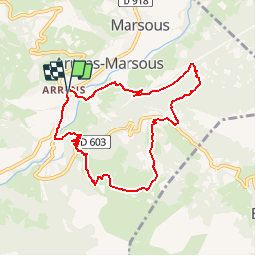
Ruta Senderismo de 8,5 km a descubrir en Occitania, Altos-Pirineos, Arrens-Marsous. Esta ruta ha sido propuesta por tracegps.
Descripción
Boucle de 8,5 km au départ d'Arrens-Marsous. Montée progressive jusqu'au col des Bordères (possibilité de monter jusqu'au pic de Pan 1h30 aller retour). De beaux panoramas sur les villages de Marsous, Aucun, et la montagne Soum de la Pene puis arrivé au Turon des Aulhès. Magnifique paysage sur les pics du Gabizos. Descente raide, prudence recommandée.
Localización
Comentarios
Excursiones cerca
![Excursión Senderismo Arcizans-Dessus - la fontaine de Nabias - Photo](https://media.geolcdn.com/t/375/260/7a92cfc2-a248-4e38-88ec-b8751d1d13fa.jpg&format=jpg&maxdim=2)
![Senderismo Senderismo](https://static1.geolcdn.com/sitytour/trail-icons/101.png)
Senderismo
![](/images/other/stat-length.png)
![](https://static1.geolcdn.com/siteimages/upload/files/16400158638029165_repeat_loop_refresh_sync_direction_icon.png)
![Excursión Raquetas de nieve Aucun - Le Soum de Berducou - Photo](https://media.geolcdn.com/t/375/260/ext.jpg?maxdim=2&url=https%3A%2F%2Fservices.sitytrail.com%2FGeolivesWS%2FDownloadMedia.ashx%3FTrailID%3D110337%26Media%3D5784_1.jpg)
![Raquetas de nieve Raquetas de nieve](https://static1.geolcdn.com/sitytour/trail-icons/504.png)
Raquetas de nieve
![](/images/other/stat-length.png)
![](https://static1.geolcdn.com/siteimages/upload/files/16400158638029165_repeat_loop_refresh_sync_direction_icon.png)
![Excursión Senderismo Estaing - Les Viellettes - Estaing - Photo](https://media.geolcdn.com/t/375/260/ext.jpg?maxdim=2&url=https%3A%2F%2Fservices.sitytrail.com%2FGeolivesWS%2FDownloadMedia.ashx%3FTrailID%3D101311%26Media%3D806_1.jpg)
![Senderismo Senderismo](https://static1.geolcdn.com/sitytour/trail-icons/101.png)
Senderismo
![](/images/other/stat-length.png)
![](https://static1.geolcdn.com/siteimages/upload/files/16400158638029165_repeat_loop_refresh_sync_direction_icon.png)
![Excursión Senderismo Gaillagos - GAILLAGOS / Couret / Couraduque en boucle reco G3 - Photo](https://media.geolcdn.com/t/375/260/2bb3641c-adfa-48ae-af2a-1b58bf8f8276.jpg&format=jpg&maxdim=2)
![Senderismo Senderismo](https://static1.geolcdn.com/sitytour/trail-icons/101.png)
Senderismo
![](/images/other/stat-length.png)
![](https://static1.geolcdn.com/siteimages/upload/files/16400158638029165_repeat_loop_refresh_sync_direction_icon.png)
![Excursión Senderismo Arrens-Marsous - ARRENS MARSOUS Le Turon des aulhes 2906361 - Photo](https://media.geolcdn.com/t/375/260/11ee13f3-f703-440e-9be7-4acb8ea55d91.jpg&format=jpg&maxdim=2)
![Senderismo Senderismo](https://static1.geolcdn.com/sitytour/trail-icons/101.png)
Senderismo
![](/images/other/stat-length.png)
![](https://static1.geolcdn.com/siteimages/upload/files/16400158638029165_repeat_loop_refresh_sync_direction_icon.png)
![Excursión Deportes de invierno Aucun - couraduc soulor - Photo](https://media.geolcdn.com/t/375/260/ext.jpg?maxdim=2&url=https%3A%2F%2Fstatic1.geolcdn.com%2Fsiteimages%2Fupload%2Ffiles%2F1524743153ski.jpg)
![Deportes de invierno Deportes de invierno](https://static1.geolcdn.com/sitytour/trail-icons/500.png)
Deportes de invierno
![](/images/other/stat-length.png)
![](https://static1.geolcdn.com/siteimages/upload/files/16400158638029165_repeat_loop_refresh_sync_direction_icon.png)
![Excursión Deportes de invierno Aucun - Bazes soulor - Photo](https://media.geolcdn.com/t/375/260/ext.jpg?maxdim=2&url=https%3A%2F%2Fstatic1.geolcdn.com%2Fsiteimages%2Fupload%2Ffiles%2F1524743153ski.jpg)
![Deportes de invierno Deportes de invierno](https://static1.geolcdn.com/sitytour/trail-icons/500.png)
Deportes de invierno
![](/images/other/stat-length.png)
![](https://static1.geolcdn.com/siteimages/upload/files/16400158638029165_repeat_loop_refresh_sync_direction_icon.png)
![Excursión Senderismo Arrens-Marsous - col de soulor, lac de soum, col de bazes, col de soulor - Photo](https://media.geolcdn.com/t/375/260/9c3094c8-45a9-4b5a-9dd6-274e8c565d12.jpg&format=jpg&maxdim=2)
![Senderismo Senderismo](https://static1.geolcdn.com/sitytour/trail-icons/101.png)
Senderismo
![](/images/other/stat-length.png)
![](https://static1.geolcdn.com/siteimages/upload/files/16400158638029165_repeat_loop_refresh_sync_direction_icon.png)
![Excursión Senderismo Gaillagos - GAILLAGOS Col de Couret Couraduque en boucle G3 du 21/04/2023](https://media.geolcdn.com/t/375/260/a7a6faba-e7ef-4e8d-a26e-e7db5f8feac1.jpg&format=jpg&maxdim=2)
![Senderismo Senderismo](https://static1.geolcdn.com/sitytour/trail-icons/101.png)
Senderismo
![](/images/other/stat-length.png)
![](https://static1.geolcdn.com/siteimages/upload/files/16400158638029165_repeat_loop_refresh_sync_direction_icon.png)
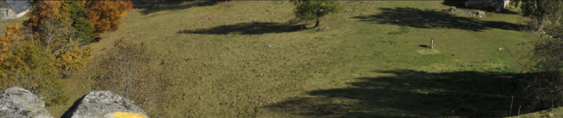
Belle rando. Faire l'effort de l'ascension du Pic de Pan, le paysage vous apportera la récompense pour l'effort.