![](/images/other/stat-length.png)
![Excursión Bici de montaña Courbevoie - VTT à Boulogne Billancourt, Parc de St Cloud et forêt de Fausses Reposes - Photo](https://media.geolcdn.com/t/1900/400/ext.pjpeg?maxdim=2&url=https%3A%2F%2Fstatic1.geolcdn.com%2Fsiteimages%2Fupload%2Ffiles%2F1524743154velo.jpg)
VTT à Boulogne Billancourt, Parc de St Cloud et forêt de Fausses Reposes
tracegps
Usuario
![Longitud](/images/other/stat-length.png)
![Altitud máxima](https://static1.geolcdn.com/siteimages/upload/files/1508320355ic_sort_altitude_max_24dp.png)
![Desnivel positivo](https://static1.geolcdn.com/siteimages/upload/files/1508320355ic_sort_den_pos_24dp.png)
![Km-Effort](/images/other/stat-length.png)
![Altitud mínima](https://static1.geolcdn.com/siteimages/upload/files/1508320355ic_sort_altitude_min_24dp.png)
![Desnivel negativo](https://static1.geolcdn.com/siteimages/upload/files/1508320355ic_sort_den_neg_24dp.png)
![Boucle](https://static1.geolcdn.com/siteimages/upload/files/16400158638029165_repeat_loop_refresh_sync_direction_icon.png)
![Bici de montaña](https://static1.geolcdn.com/sitytour/trail-icons/202.png)
2h30
Dificultad : Difícil
![Escanee este código QR para abrir la excursión en la aplicación SityTrail](https://capi.geolives.com/qq0zvz2zws4bq2lad0pu/sitytour/trails/107283/qr.png?size=200)
Aplicación GPS de excursión GRATIS
A propósito
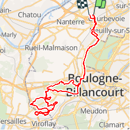
Ruta Bici de montaña de 41 km a descubrir en Isla de Francia, Altos del Sena, Courbevoie. Esta ruta ha sido propuesta por tracegps.
Descripción
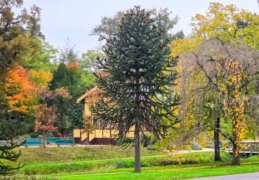
Le circuit démarre de Courbevoie / Puteaux ou Boulogne / Neuilly. Les choses sérieuses commencent le long du bois de Boulogne, en bord de Seine, un sentier ludique (attention aux piétons). Puis on traverse la Seine. On entre dans le Parc de St Cloud en longeant le coté de Sévres puis la forêt de Fausses Reposes (une cote très difficile sur 50m). On prend des pistes ou des singles. Puis retour au Bois de St Cloud et Boulogne. Environ 35/40km avec 700m de d env.
Localización
Comentarios
Excursiones cerca
![Excursión Senderismo Rueil-Malmaison - St Germain en Laye - Rueil Malmaison 28 km Inversee - Photo](https://media.geolcdn.com/t/375/260/b687f904-9338-4fa0-aef2-9bacff37d877.jpg&format=jpg&maxdim=2)
![Senderismo Senderismo](https://static1.geolcdn.com/sitytour/trail-icons/101.png)
Senderismo
![](/images/other/stat-length.png)
![](https://static1.geolcdn.com/siteimages/upload/files/16400158638029165_repeat_loop_refresh_sync_direction_icon.png)
![Excursión Senderismo París - SityTrail - 008.2 - Paris - de place Blanche aux Halles - Photo](https://media.geolcdn.com/t/375/260/6eac2f44-ae7d-4c3a-b4a0-edb2243c2709.jpeg&format=jpg&maxdim=2)
![Senderismo Senderismo](https://static1.geolcdn.com/sitytour/trail-icons/101.png)
Senderismo
![](/images/other/stat-length.png)
![](https://static1.geolcdn.com/siteimages/upload/files/16400158638029165_repeat_loop_refresh_sync_direction_icon.png)
![Excursión Senderismo París - DP75-11 De Boulainvilliers à pont du Garigliano - Photo](https://media.geolcdn.com/t/375/260/65f6b9b8-257b-4cb3-ae12-0b82159348dc.jpg&format=jpg&maxdim=2)
![Senderismo Senderismo](https://static1.geolcdn.com/sitytour/trail-icons/101.png)
Senderismo
![](/images/other/stat-length.png)
![](https://static1.geolcdn.com/siteimages/upload/files/16400158638029165_repeat_loop_refresh_sync_direction_icon.png)
![Excursión Senderismo París - DP75-31 De Passy à Charles-Michel - Photo](https://media.geolcdn.com/t/375/260/96431e96-6d3c-47dc-91ae-d446da1f3a1d.jpg&format=jpg&maxdim=2)
![Senderismo Senderismo](https://static1.geolcdn.com/sitytour/trail-icons/101.png)
Senderismo
![](/images/other/stat-length.png)
![](https://static1.geolcdn.com/siteimages/upload/files/16400158638029165_repeat_loop_refresh_sync_direction_icon.png)
![Excursión Senderismo París - DP75-19 de Porte-Maillot à Europe - Photo](https://media.geolcdn.com/t/375/260/159be267-b3d1-40ca-b7c5-4227580bd0ba.jpg&format=jpg&maxdim=2)
![Senderismo Senderismo](https://static1.geolcdn.com/sitytour/trail-icons/101.png)
Senderismo
![](/images/other/stat-length.png)
![](https://static1.geolcdn.com/siteimages/upload/files/16400158638029165_repeat_loop_refresh_sync_direction_icon.png)
![Excursión Senderismo París - 75-05-Paris les Boulevards 13km-625-799- - Photo](https://media.geolcdn.com/t/375/260/65e75e6a-35fa-4760-a028-d929907d2fd8.jpg&format=jpg&maxdim=2)
![Senderismo Senderismo](https://static1.geolcdn.com/sitytour/trail-icons/101.png)
Senderismo
![](/images/other/stat-length.png)
![](https://static1.geolcdn.com/siteimages/upload/files/16400158638029165_repeat_loop_refresh_sync_direction_icon.png)
![Excursión Senderismo París - GPS Drawing Chess in Paris 30 km - Photo](https://media.geolcdn.com/t/375/260/9d788214-8401-43d3-9160-1b02f73f9d64.jpg&format=jpg&maxdim=2)
![Senderismo Senderismo](https://static1.geolcdn.com/sitytour/trail-icons/101.png)
Senderismo
![](/images/other/stat-length.png)
![](https://static1.geolcdn.com/siteimages/upload/files/16400158638029165_repeat_loop_refresh_sync_direction_icon.png)
![Excursión A pie París - Balade parisienne autour d'un RVM - Photo](https://media.geolcdn.com/t/375/260/949fecf4-9911-4cef-a908-6b0d8ad48568.jpg&format=jpg&maxdim=2)
![A pie A pie](https://static1.geolcdn.com/sitytour/trail-icons/100.png)
A pie
![](/images/other/stat-length.png)
![](https://static1.geolcdn.com/siteimages/upload/files/16400158638029165_repeat_loop_refresh_sync_direction_icon.png)
![Excursión A pie París - Nocturnes Paris 2023 Rcy - Photo](https://media.geolcdn.com/t/375/260/27416f25-929c-413d-84fd-f2ff881db7fd.jpg&format=jpg&maxdim=2)
![A pie A pie](https://static1.geolcdn.com/sitytour/trail-icons/100.png)
A pie
![](/images/other/stat-length.png)
![](https://static1.geolcdn.com/siteimages/upload/files/16400158638029165_repeat_loop_refresh_sync_direction_icon.png)