![](/images/other/stat-length.png)
![Excursión Senderismo Grignan - Grignan chemin des rabasses - Photo](https://media.geolcdn.com/t/1900/400/ext.pjpeg?maxdim=2&url=https%3A%2F%2Fstatic1.geolcdn.com%2Fsiteimages%2Fupload%2Ffiles%2F1553511878bg_sport_marche.png)
Grignan chemin des rabasses
aitkhedache
Usuario
![Longitud](/images/other/stat-length.png)
Longitud
7,5 km
![Altitud máxima](https://static1.geolcdn.com/siteimages/upload/files/1508320355ic_sort_altitude_max_24dp.png)
Altitud máxima
243 m
![Desnivel positivo](https://static1.geolcdn.com/siteimages/upload/files/1508320355ic_sort_den_pos_24dp.png)
Desnivel positivo
92 m
![Km-Effort](/images/other/stat-length.png)
Km-Effort
8,7 km
![Altitud mínima](https://static1.geolcdn.com/siteimages/upload/files/1508320355ic_sort_altitude_min_24dp.png)
Altitud mínima
185 m
![Desnivel negativo](https://static1.geolcdn.com/siteimages/upload/files/1508320355ic_sort_den_neg_24dp.png)
Desnivel negativo
90 m
![Boucle](https://static1.geolcdn.com/siteimages/upload/files/16400158638029165_repeat_loop_refresh_sync_direction_icon.png)
Boucle
Sí
Fecha de creación :
2019-01-15 18:54:15.316
Última modificación :
2019-01-15 18:54:15.316
![Senderismo](https://static1.geolcdn.com/sitytour/trail-icons/101.png)
2h17
Dificultad : Muy fácil
![Escanee este código QR para abrir la excursión en la aplicación SityTrail](https://capi.geolives.com/qq0zvz2zws4bq2lad0pu/sitytour/trails/1072535/qr.png?size=200)
Aplicación GPS de excursión GRATIS
A propósito
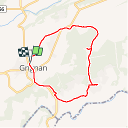
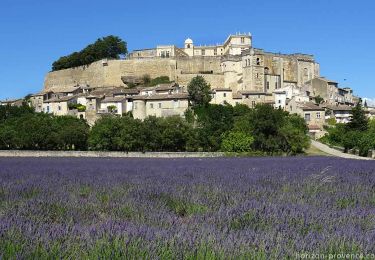
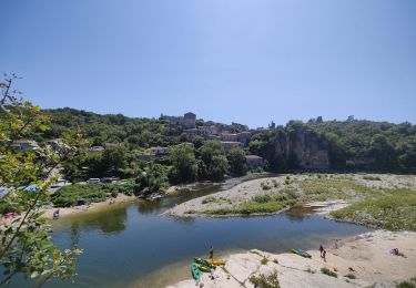
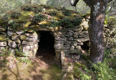
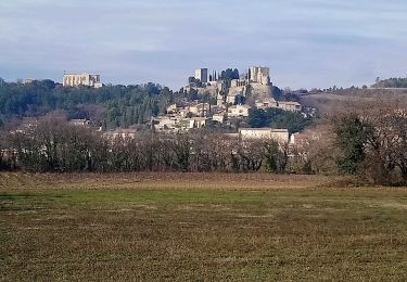
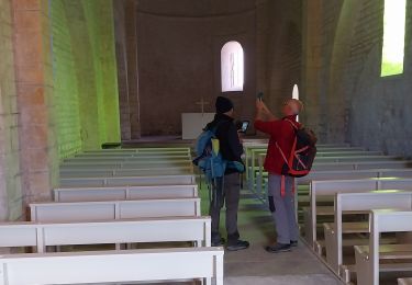
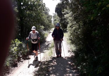
Ruta Senderismo de 7,5 km a descubrir en Auvergne-Rhône-Alpes, Drôme, Grignan. Esta ruta ha sido propuesta por aitkhedache.
Descripción
Un balade familiale tranquille ombragée et sur des chemins bien entretenus. À la portée de tout le monde.
Localización
País:
France
Región :
Auvergne-Rhône-Alpes
Departamento/provincia :
Drôme
Municipio :
Grignan
Localidad:
Unknown
Salida:(Dec)
Salida:(UTM)
651983 ; 4920511 (31T) N.
Comentarios
Excursiones cerca
![Excursión Senderismo Grignan - grignan 26 01 14 - Photo](https://media.geolcdn.com/t/375/260/ext.jpg?maxdim=2&url=https%3A%2F%2Fstatic1.geolcdn.com%2Fsiteimages%2Fupload%2Ffiles%2F1553511878bg_sport_marche.png)
![Senderismo Senderismo](https://static1.geolcdn.com/sitytour/trail-icons/101.png)
grignan 26 01 14
Senderismo
Fácil
(1)
Grignan,
Auvergne-Rhône-Alpes,
Drôme,
France
![](/images/other/stat-length.png)
13,1 km | 15,4 km-effort
2h 27min
![](https://static1.geolcdn.com/siteimages/upload/files/16400158638029165_repeat_loop_refresh_sync_direction_icon.png)
Sí
![Excursión Senderismo Salles-sous-Bois - 26 cool aleyrac zel - Photo](https://media.geolcdn.com/t/375/260/8b75a5eb-176f-46b9-8ee6-7e3265b1d362.jpg&format=jpg&maxdim=2)
![Senderismo Senderismo](https://static1.geolcdn.com/sitytour/trail-icons/101.png)
26 cool aleyrac zel
Senderismo
Fácil
Salles-sous-Bois,
Auvergne-Rhône-Alpes,
Drôme,
France
![](/images/other/stat-length.png)
9,4 km | 12,9 km-effort
3h 49min
![](https://static1.geolcdn.com/siteimages/upload/files/16400158638029165_repeat_loop_refresh_sync_direction_icon.png)
No
![Excursión Senderismo Grignan - Grignan Rochecourbière Chamaret 18km. - Photo](https://media.geolcdn.com/t/375/260/81319c6a-3c08-4721-a8c4-dbc775711d9a.jpg&format=jpg&maxdim=2)
![Senderismo Senderismo](https://static1.geolcdn.com/sitytour/trail-icons/101.png)
Grignan Rochecourbière Chamaret 18km.
Senderismo
Muy difícil
Grignan,
Auvergne-Rhône-Alpes,
Drôme,
France
![](/images/other/stat-length.png)
17,5 km | 21 km-effort
4h 48min
![](https://static1.geolcdn.com/siteimages/upload/files/16400158638029165_repeat_loop_refresh_sync_direction_icon.png)
Sí
![Excursión Senderismo Grignan - 2023-02-15_20h34m42_Grignan Les montines 8km.gpx (1).xml - Photo](https://media.geolcdn.com/t/375/260/b983453f-a09f-47ba-85f0-6545fdc4ac36.jpg&format=jpg&maxdim=2)
![Senderismo Senderismo](https://static1.geolcdn.com/sitytour/trail-icons/101.png)
2023-02-15_20h34m42_Grignan Les montines 8km.gpx (1).xml
Senderismo
Medio
Grignan,
Auvergne-Rhône-Alpes,
Drôme,
France
![](/images/other/stat-length.png)
9,5 km | 11,4 km-effort
2h 35min
![](https://static1.geolcdn.com/siteimages/upload/files/16400158638029165_repeat_loop_refresh_sync_direction_icon.png)
Sí
![Senderismo Senderismo](https://static1.geolcdn.com/sitytour/trail-icons/101.png)
2022-09-05_09h48m42_Chamaret Rochecourbière 14km.gpx.xml
Senderismo
Medio
Chamaret,
Auvergne-Rhône-Alpes,
Drôme,
France
![](/images/other/stat-length.png)
14,1 km | 16,8 km-effort
3h 51min
![](https://static1.geolcdn.com/siteimages/upload/files/16400158638029165_repeat_loop_refresh_sync_direction_icon.png)
Sí
![Excursión Senderismo Chamaret - Borries de chamaret - Photo](https://media.geolcdn.com/t/375/260/b3d37c72-f479-4372-af81-515832aa3dd7.jpg&format=jpg&maxdim=2)
![Senderismo Senderismo](https://static1.geolcdn.com/sitytour/trail-icons/101.png)
Borries de chamaret
Senderismo
Muy fácil
Chamaret,
Auvergne-Rhône-Alpes,
Drôme,
France
![](/images/other/stat-length.png)
5,1 km | 6,1 km-effort
2h 23min
![](https://static1.geolcdn.com/siteimages/upload/files/16400158638029165_repeat_loop_refresh_sync_direction_icon.png)
Sí
![Excursión Senderismo Montjoyer - Valaurie Aiguebelle 20km - Photo](https://media.geolcdn.com/t/375/260/4320fd96-8d73-4746-9b13-76f7ba88a847.jpg&format=jpg&maxdim=2)
![Senderismo Senderismo](https://static1.geolcdn.com/sitytour/trail-icons/101.png)
Valaurie Aiguebelle 20km
Senderismo
Medio
Montjoyer,
Auvergne-Rhône-Alpes,
Drôme,
France
![](/images/other/stat-length.png)
19,6 km | 26 km-effort
6h 17min
![](https://static1.geolcdn.com/siteimages/upload/files/16400158638029165_repeat_loop_refresh_sync_direction_icon.png)
Sí
![Excursión Senderismo Grignan - grignan 14 01 22 - Photo](https://media.geolcdn.com/t/375/260/47a5462e-afdb-4437-9945-e1af8bfde7b9.jpg&format=jpg&maxdim=2)
![Senderismo Senderismo](https://static1.geolcdn.com/sitytour/trail-icons/101.png)
grignan 14 01 22
Senderismo
Muy difícil
Grignan,
Auvergne-Rhône-Alpes,
Drôme,
France
![](/images/other/stat-length.png)
18,3 km | 22 km-effort
6h 2min
![](https://static1.geolcdn.com/siteimages/upload/files/16400158638029165_repeat_loop_refresh_sync_direction_icon.png)
Sí
![Excursión Senderismo Réauville - reau 08 06 20 - Photo](https://media.geolcdn.com/t/375/260/4361955a-0e4b-4ce6-999c-34591979f7b2.jpg&format=jpg&maxdim=2)
![Senderismo Senderismo](https://static1.geolcdn.com/sitytour/trail-icons/101.png)
reau 08 06 20
Senderismo
Muy fácil
Réauville,
Auvergne-Rhône-Alpes,
Drôme,
France
![](/images/other/stat-length.png)
7,4 km | 9,5 km-effort
2h 57min
![](https://static1.geolcdn.com/siteimages/upload/files/16400158638029165_repeat_loop_refresh_sync_direction_icon.png)
Sí