![](/images/other/stat-length.png)
![Excursión Senderismo Saint-Sulpice-Laurière - Autour de Saint-Sulpice Laurière - Photo](https://media.geolcdn.com/t/1900/400/ext.pjpeg?maxdim=2&url=https%3A%2F%2Fservices.sitytrail.com%2FGeolivesWS%2FDownloadMedia.ashx%3FTrailID%3D107216%26Media%3D12081_5.jpg)
Autour de Saint-Sulpice Laurière
tracegps
Usuario
![Longitud](/images/other/stat-length.png)
![Altitud máxima](https://static1.geolcdn.com/siteimages/upload/files/1508320355ic_sort_altitude_max_24dp.png)
![Desnivel positivo](https://static1.geolcdn.com/siteimages/upload/files/1508320355ic_sort_den_pos_24dp.png)
![Km-Effort](/images/other/stat-length.png)
![Altitud mínima](https://static1.geolcdn.com/siteimages/upload/files/1508320355ic_sort_altitude_min_24dp.png)
![Desnivel negativo](https://static1.geolcdn.com/siteimages/upload/files/1508320355ic_sort_den_neg_24dp.png)
![Boucle](https://static1.geolcdn.com/siteimages/upload/files/16400158638029165_repeat_loop_refresh_sync_direction_icon.png)
![Senderismo](https://static1.geolcdn.com/sitytour/trail-icons/101.png)
8h00
Dificultad : Difícil
![Escanee este código QR para abrir la excursión en la aplicación SityTrail](https://capi.geolives.com/qq0zvz2zws4bq2lad0pu/sitytour/trails/107216/qr.png?size=200)
Aplicación GPS de excursión GRATIS
A propósito
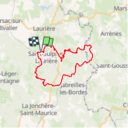
Ruta Senderismo de 28 km a descubrir en Nueva Aquitania, Alto Vienne, Saint-Sulpice-Laurière. Esta ruta ha sido propuesta por tracegps.
Descripción
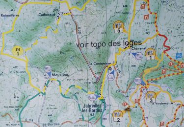
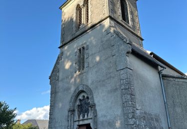
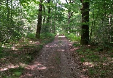
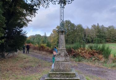
Que faire quand vous vous ennuyez le week-end à Châteauroux, que les massifs montagneux les plus proches (Auvergne) sont à plus de 200 km ? Prenez votre GPS et allez vous perdre dans le Limousin, plus particulièrement dans les collines boisées d'Ambazac, où vous aurez le privilège de ne voir que vous-même et votre ombre sur des dizaines de kilomètres, tout en cumulant un dénivelé positif tout à fait convenable pour la région (850-900 m). La randonnée que je propose ici est un circuit original que l'on ne ferait pas sans GPS, à moins d'être très calé en orientation. Quelques portions du circuit sont en effet effectuées hors sentiers dans des forêts plus ou moins propres (attention aux ronces et aux genêts), et je suis certain que la trace pourra être optimisée pour certains endroits. Si vous aimez les belles forêts et les villages de caractère, vous serez servis. Après le déjeuner pris sur le pont du Rivalier à la Courrière, vous ferez une sieste bien méritée, bercé par le bruit du ruisseau ; puis vous reprendrez votre route jusqu'à Saint-Sulpice, en ayant pris soin d'effectuer un petit détour par la Pierre du Roy.
Localización
Comentarios
Excursiones cerca
![Excursión Senderismo Jabreilles-les-Bordes - Jabreilles-les-Bordes - Photo](https://media.geolcdn.com/t/375/260/ae0dafc1-f2e9-40f9-9577-753ddfa7d86e.jpg&format=jpg&maxdim=2)
![Senderismo Senderismo](https://static1.geolcdn.com/sitytour/trail-icons/101.png)
Senderismo
![](/images/other/stat-length.png)
![](https://static1.geolcdn.com/siteimages/upload/files/16400158638029165_repeat_loop_refresh_sync_direction_icon.png)
![Excursión sport Saint-Léger-la-Montagne - De Sauvagnac au relais - Photo](https://media.geolcdn.com/t/375/260/ext.jpg?maxdim=2&url=https%3A%2F%2Fsecurestorage.geolives.com%2Fsitytour%2Ftrail-bg%2Fdefault.jpg)
sport
![](/images/other/stat-length.png)
![](https://static1.geolcdn.com/siteimages/upload/files/16400158638029165_repeat_loop_refresh_sync_direction_icon.png)
![Excursión sport Saint-Léger-la-Montagne - Sauvagnac AR par lac de Pierre Miller - Photo](https://media.geolcdn.com/t/375/260/97fc1be5-1906-4299-87e7-79596504adcb.jpg&format=jpg&maxdim=2)
sport
![](/images/other/stat-length.png)
![](https://static1.geolcdn.com/siteimages/upload/files/16400158638029165_repeat_loop_refresh_sync_direction_icon.png)
![Excursión Senderismo Bersac-sur-Rivalier - Bersac-sur-Rivalier - Tour de Bersac - 15 km - Photo](https://media.geolcdn.com/t/375/260/ext.jpg?maxdim=2&url=https%3A%2F%2Fstatic1.geolcdn.com%2Fsiteimages%2Fupload%2Ffiles%2F1553511878bg_sport_marche.png)
![Senderismo Senderismo](https://static1.geolcdn.com/sitytour/trail-icons/101.png)
Senderismo
![](/images/other/stat-length.png)
![](https://static1.geolcdn.com/siteimages/upload/files/16400158638029165_repeat_loop_refresh_sync_direction_icon.png)
![Excursión Paseo ecuestre Saint-Léger-la-Montagne - Tourbière des Dauges - Photo](https://media.geolcdn.com/t/375/260/ext.jpg?maxdim=2&url=https%3A%2F%2Fstatic1.geolcdn.com%2Fsiteimages%2Fupload%2Ffiles%2F1524743154cheval.jpg)
![Paseo ecuestre Paseo ecuestre](https://static1.geolcdn.com/sitytour/trail-icons/301.png)
Paseo ecuestre
![](/images/other/stat-length.png)
![](https://static1.geolcdn.com/siteimages/upload/files/16400158638029165_repeat_loop_refresh_sync_direction_icon.png)
![Excursión Otra actividad Laurière - pont à l'âge Lauriere - Photo](https://media.geolcdn.com/t/375/260/ext.jpg?maxdim=2&url=https%3A%2F%2Fservices.sitytrail.com%2FGeolivesWS%2FDownloadMedia.ashx%3FTrailID%3D435386%26Media%3Dfix__20150529165924.jpg)
![Otra actividad Otra actividad](https://static1.geolcdn.com/sitytour/trail-icons/900.png)
Otra actividad
![](/images/other/stat-length.png)
![](https://static1.geolcdn.com/siteimages/upload/files/16400158638029165_repeat_loop_refresh_sync_direction_icon.png)
![Excursión Senderismo Saint-Léger-la-Montagne - Saint Leger la Montagne - pierre tremblante - Photo](https://media.geolcdn.com/t/375/260/caa23b69-3153-43e9-ae42-5b6b6e061e5c.jpg&format=jpg&maxdim=2)
![Senderismo Senderismo](https://static1.geolcdn.com/sitytour/trail-icons/101.png)
Senderismo
![](/images/other/stat-length.png)
![](https://static1.geolcdn.com/siteimages/upload/files/16400158638029165_repeat_loop_refresh_sync_direction_icon.png)
![Excursión Senderismo Saint-Léger-la-Montagne - Sejour Les Monts d'Ambazac - Journée 4 - Photo](https://media.geolcdn.com/t/375/260/ext.jpg?maxdim=2&url=https%3A%2F%2Fstatic1.geolcdn.com%2Fsiteimages%2Fupload%2Ffiles%2F1553511878bg_sport_marche.png)
![Senderismo Senderismo](https://static1.geolcdn.com/sitytour/trail-icons/101.png)
Senderismo
![](/images/other/stat-length.png)
![](https://static1.geolcdn.com/siteimages/upload/files/16400158638029165_repeat_loop_refresh_sync_direction_icon.png)
![Excursión Senderismo Bersac-sur-Rivalier - Sejour Les Monts d'Ambazac - Journée 3 - Photo](https://media.geolcdn.com/t/375/260/ext.jpg?maxdim=2&url=https%3A%2F%2Fstatic1.geolcdn.com%2Fsiteimages%2Fupload%2Ffiles%2F1553511878bg_sport_marche.png)
![Senderismo Senderismo](https://static1.geolcdn.com/sitytour/trail-icons/101.png)
Senderismo
![](/images/other/stat-length.png)
![](https://static1.geolcdn.com/siteimages/upload/files/16400158638029165_repeat_loop_refresh_sync_direction_icon.png)