![](/images/other/stat-length.png)
![Excursión Senderismo Cléden-Cap-Sizun - Chapelle de Langroas - Cléden Cap Sizun - Photo](https://media.geolcdn.com/t/1900/400/ext.pjpeg?maxdim=2&url=https%3A%2F%2Fstatic1.geolcdn.com%2Fsiteimages%2Fupload%2Ffiles%2F1553511878bg_sport_marche.png)
Chapelle de Langroas - Cléden Cap Sizun
tracegps
Usuario
![Longitud](/images/other/stat-length.png)
![Altitud máxima](https://static1.geolcdn.com/siteimages/upload/files/1508320355ic_sort_altitude_max_24dp.png)
![Desnivel positivo](https://static1.geolcdn.com/siteimages/upload/files/1508320355ic_sort_den_pos_24dp.png)
![Km-Effort](/images/other/stat-length.png)
![Altitud mínima](https://static1.geolcdn.com/siteimages/upload/files/1508320355ic_sort_altitude_min_24dp.png)
![Desnivel negativo](https://static1.geolcdn.com/siteimages/upload/files/1508320355ic_sort_den_neg_24dp.png)
![Boucle](https://static1.geolcdn.com/siteimages/upload/files/16400158638029165_repeat_loop_refresh_sync_direction_icon.png)
![Senderismo](https://static1.geolcdn.com/sitytour/trail-icons/101.png)
3h37
Dificultad : Difícil
![Escanee este código QR para abrir la excursión en la aplicación SityTrail](https://capi.geolives.com/qq0zvz2zws4bq2lad0pu/sitytour/trails/107178/qr.png?size=200)
Aplicación GPS de excursión GRATIS
A propósito
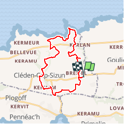
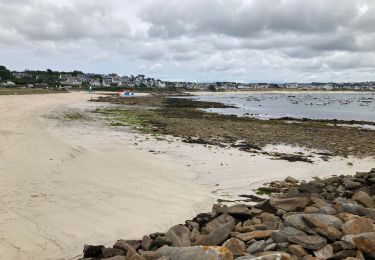
Ruta Senderismo de 14,6 km a descubrir en Bretaña, Finisterre, Cléden-Cap-Sizun. Esta ruta ha sido propuesta por tracegps.
Descripción
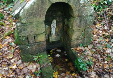
Départ chapelle de Langroas (D43). Prendre la D43 vers Quillivic, tourner à droite entre deux maisons à l'entrée du hameau, prendre le sentier à droite vers Lannuet, prendre tout de suite à droite le sentier qui descend. Suivre ce sentier jusqu'au min rné, continuer sur la route, et tourner à droite, puis encore à droite vers Penharn. Suivre un moment le GR34,et le quitter au niveau de Trouérennec. Suivre le sentier, tourner à gauche, traverser la D7,(calvaire),tourner à gauche à Trevénan, et suivre le sentier herbeux. Passer un nouveau moulin ruiné à Kergroas, passer le carrefour, prendre à gauche vers Kerfeurguel, puis un petit sentier entre des murs de clôture. Rejoindre Cléden, passer devant l'église, tourner à gauche, passer le cimetière, et descendre jusque Kerham. Tourner à gauche vers St Trémeur descendre la route, tourner à gauche vers Lamboban, Kerdiern ar veil monter le raidillon, prendre le sentier à droite puis à gauche en bas, à droite sur la route, rejoindre le parking.
Localización
Comentarios
Excursiones cerca
![Excursión Otra actividad Goulien - gr34 - Photo](https://media.geolcdn.com/t/375/260/ext.jpg?maxdim=2&url=https%3A%2F%2Fservices.sitytrail.com%2FGeolivesWS%2FDownloadMedia.ashx%3FTrailID%3D554552%26Media%3Dfix__20160416170328.jpg)
![Otra actividad Otra actividad](https://static1.geolcdn.com/sitytour/trail-icons/900.png)
Otra actividad
![](/images/other/stat-length.png)
![](https://static1.geolcdn.com/siteimages/upload/files/16400158638029165_repeat_loop_refresh_sync_direction_icon.png)
![Excursión Senderismo Cléden-Cap-Sizun - GR34 Pointe de Brézelec -- Cléden-Cap-Sizun (Pointe du Raz) - Photo](https://media.geolcdn.com/t/375/260/c8e4b333-f389-409b-a569-fa6f65a7aa66.jpg&format=jpg&maxdim=2)
![Senderismo Senderismo](https://static1.geolcdn.com/sitytour/trail-icons/101.png)
Senderismo
![](/images/other/stat-length.png)
![](https://static1.geolcdn.com/siteimages/upload/files/16400158638029165_repeat_loop_refresh_sync_direction_icon.png)
![Excursión Senderismo Audierne - TREK RCY GR34 2022 J5 Audierne - Du gite à l'embarcadère - Photo](https://media.geolcdn.com/t/375/260/c8ceb096-71a9-4fb0-a364-a75aaaad50cc.jpg&format=jpg&maxdim=2)
![Senderismo Senderismo](https://static1.geolcdn.com/sitytour/trail-icons/101.png)
Senderismo
![](/images/other/stat-length.png)
![](https://static1.geolcdn.com/siteimages/upload/files/16400158638029165_repeat_loop_refresh_sync_direction_icon.png)
![Excursión Senderismo Cléden-Cap-Sizun - Gr34 Cléden-Cap-Sizun -- Audierne - Photo](https://media.geolcdn.com/t/375/260/5b525b84-6ac9-4943-b831-b8f433338692.jpg&format=jpg&maxdim=2)
![Senderismo Senderismo](https://static1.geolcdn.com/sitytour/trail-icons/101.png)
Senderismo
![](/images/other/stat-length.png)
![](https://static1.geolcdn.com/siteimages/upload/files/16400158638029165_repeat_loop_refresh_sync_direction_icon.png)
![Excursión Senderismo Goulien - GOULIEN - Photo](https://media.geolcdn.com/t/375/260/7d93338c-6c83-49ac-83d8-859cc48046aa.jpg&format=jpg&maxdim=2)
![Senderismo Senderismo](https://static1.geolcdn.com/sitytour/trail-icons/101.png)
![Excursión Senderismo Primelin - Primelin - Photo](https://media.geolcdn.com/t/375/260/e9bb4270-c545-4dc1-bef9-cc78994ac423.jpg&format=jpg&maxdim=2)
![Senderismo Senderismo](https://static1.geolcdn.com/sitytour/trail-icons/101.png)
Senderismo
![](/images/other/stat-length.png)
![](https://static1.geolcdn.com/siteimages/upload/files/16400158638029165_repeat_loop_refresh_sync_direction_icon.png)
![Excursión Senderismo Plogoff - Tour Pointe du Raz et du Van - Cap Sizun - Photo](https://media.geolcdn.com/t/375/260/ext.jpg?maxdim=2&url=https%3A%2F%2Fservices.sitytrail.com%2FGeolivesWS%2FDownloadMedia.ashx%3FTrailID%3D914517%26Media%3Dfix__20180225155327.jpg)
![Senderismo Senderismo](https://static1.geolcdn.com/sitytour/trail-icons/101.png)
Senderismo
![](/images/other/stat-length.png)
![](https://static1.geolcdn.com/siteimages/upload/files/16400158638029165_repeat_loop_refresh_sync_direction_icon.png)
![Excursión Senderismo Cléden-Cap-Sizun - le tour de la Pointe du Raz et de la Pointe du Van - Photo](https://media.geolcdn.com/t/375/260/ext.jpg?maxdim=2&url=https%3A%2F%2Fservices.sitytrail.com%2FGeolivesWS%2FDownloadMedia.ashx%3FTrailID%3D142731%26Media%3D20120731175933.jpg)
![Senderismo Senderismo](https://static1.geolcdn.com/sitytour/trail-icons/101.png)
Senderismo
![](/images/other/stat-length.png)
![](https://static1.geolcdn.com/siteimages/upload/files/16400158638029165_repeat_loop_refresh_sync_direction_icon.png)
![Excursión Senderismo Audierne - Audierne - Esquibien - Photo](https://media.geolcdn.com/t/375/260/436a95d4-8c2c-418c-a40b-e8085addf12b.jpg&format=jpg&maxdim=2)
![Senderismo Senderismo](https://static1.geolcdn.com/sitytour/trail-icons/101.png)
Senderismo
![](/images/other/stat-length.png)
![](https://static1.geolcdn.com/siteimages/upload/files/16400158638029165_repeat_loop_refresh_sync_direction_icon.png)