![](/images/other/stat-length.png)
![Excursión Senderismo Ramonchamp - Les Etangs Noirs - Le Thillot - Photo](https://media.geolcdn.com/t/1900/400/ext.pjpeg?maxdim=2&url=https%3A%2F%2Fservices.sitytrail.com%2FGeolivesWS%2FDownloadMedia.ashx%3FTrailID%3D107110%26Media%3D11941_6.jpg)
Les Etangs Noirs - Le Thillot
tracegps
Usuario
![Longitud](/images/other/stat-length.png)
Longitud
6,1 km
![Altitud máxima](https://static1.geolcdn.com/siteimages/upload/files/1508320355ic_sort_altitude_max_24dp.png)
Altitud máxima
780 m
![Desnivel positivo](https://static1.geolcdn.com/siteimages/upload/files/1508320355ic_sort_den_pos_24dp.png)
Desnivel positivo
130 m
![Km-Effort](/images/other/stat-length.png)
Km-Effort
7,9 km
![Altitud mínima](https://static1.geolcdn.com/siteimages/upload/files/1508320355ic_sort_altitude_min_24dp.png)
Altitud mínima
681 m
![Desnivel negativo](https://static1.geolcdn.com/siteimages/upload/files/1508320355ic_sort_den_neg_24dp.png)
Desnivel negativo
132 m
![Boucle](https://static1.geolcdn.com/siteimages/upload/files/16400158638029165_repeat_loop_refresh_sync_direction_icon.png)
Boucle
Sí
Fecha de creación :
2014-12-10 00:00:00.0
Última modificación :
2014-12-10 00:00:00.0
![Senderismo](https://static1.geolcdn.com/sitytour/trail-icons/101.png)
2h00
Dificultad : Medio
![Escanee este código QR para abrir la excursión en la aplicación SityTrail](https://capi.geolives.com/qq0zvz2zws4bq2lad0pu/sitytour/trails/107110/qr.png?size=200)
Aplicación GPS de excursión GRATIS
A propósito
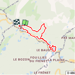
Ruta Senderismo de 6,1 km a descubrir en Gran Este, Vosgos, Ramonchamp. Esta ruta ha sido propuesta por tracegps.
Descripción
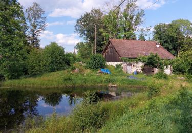
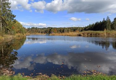
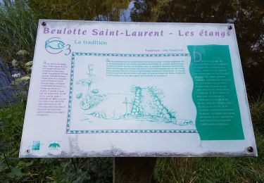
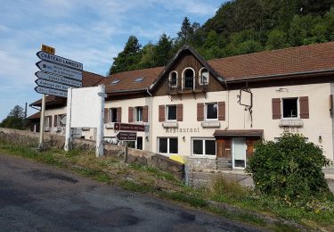
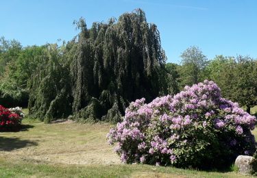
Belle randonnée autour des étangs dans le Plateau des Mille et Un Etangs. Stationnement facile sur la D57.
Localización
País:
France
Región :
Gran Este
Departamento/provincia :
Vosgos
Municipio :
Ramonchamp
Localidad:
Unknown
Salida:(Dec)
Salida:(UTM)
329115 ; 5304853 (32T) N.
Comentarios
Excursiones cerca
![Excursión Senderismo Beulotte-Saint-Laurent - Randonnée des étangs - Beulotte Saint Laurent - Photo](https://media.geolcdn.com/t/375/260/ext.jpg?maxdim=2&url=https%3A%2F%2Fservices.sitytrail.com%2FGeolivesWS%2FDownloadMedia.ashx%3FTrailID%3D107231%26Media%3D12098_5.jpg)
![Senderismo Senderismo](https://static1.geolcdn.com/sitytour/trail-icons/101.png)
Randonnée des étangs - Beulotte Saint Laurent
Senderismo
Medio
(4)
Beulotte-Saint-Laurent,
Borgoña-Franco Condado,
Alto Saona,
France
![](/images/other/stat-length.png)
10,7 km | 13,9 km-effort
2h 30min
![](https://static1.geolcdn.com/siteimages/upload/files/16400158638029165_repeat_loop_refresh_sync_direction_icon.png)
Sí
![Excursión Senderismo Beulotte-Saint-Laurent - Beulotte-Saint-Laurent 13 700m + 317m - Photo](https://media.geolcdn.com/t/375/260/ext.jpg?maxdim=2&url=https%3A%2F%2Fstatic1.geolcdn.com%2Fsiteimages%2Fupload%2Ffiles%2F1553511878bg_sport_marche.png)
![Senderismo Senderismo](https://static1.geolcdn.com/sitytour/trail-icons/101.png)
Beulotte-Saint-Laurent 13 700m + 317m
Senderismo
Fácil
(1)
Beulotte-Saint-Laurent,
Borgoña-Franco Condado,
Alto Saona,
France
![](/images/other/stat-length.png)
13,7 km | 17,9 km-effort
3h 50min
![](https://static1.geolcdn.com/siteimages/upload/files/16400158638029165_repeat_loop_refresh_sync_direction_icon.png)
Sí
![Excursión Senderismo Haut-du-Them-Château-Lambert - Chateau-Lambert mines de cuivre et source de l'Oignon - Photo](https://media.geolcdn.com/t/375/260/ext.jpg?maxdim=2&url=https%3A%2F%2Fstatic1.geolcdn.com%2Fsiteimages%2Fupload%2Ffiles%2F1553511878bg_sport_marche.png)
![Senderismo Senderismo](https://static1.geolcdn.com/sitytour/trail-icons/101.png)
Chateau-Lambert mines de cuivre et source de l'Oignon
Senderismo
Fácil
(1)
Haut-du-Them-Château-Lambert,
Borgoña-Franco Condado,
Alto Saona,
France
![](/images/other/stat-length.png)
9,6 km | 14,6 km-effort
2h 30min
![](https://static1.geolcdn.com/siteimages/upload/files/16400158638029165_repeat_loop_refresh_sync_direction_icon.png)
Sí
![Excursión Senderismo Ramonchamp - Tournée de 3 chalets - Photo](https://media.geolcdn.com/t/375/260/9772d619-fbbf-4858-9b6a-d813a318e1c1.jpeg&format=jpg&maxdim=2)
![Senderismo Senderismo](https://static1.geolcdn.com/sitytour/trail-icons/101.png)
Tournée de 3 chalets
Senderismo
Medio
Ramonchamp,
Gran Este,
Vosgos,
France
![](/images/other/stat-length.png)
6,2 km | 9 km-effort
2h 3min
![](https://static1.geolcdn.com/siteimages/upload/files/16400158638029165_repeat_loop_refresh_sync_direction_icon.png)
Sí
![Excursión Senderismo Servance-Miellin - 20230616 la petite Finlande - Photo](https://media.geolcdn.com/t/375/260/b19527b0-70e6-4e00-b48b-d0fb85eecf23.jpg&format=jpg&maxdim=2)
![Senderismo Senderismo](https://static1.geolcdn.com/sitytour/trail-icons/101.png)
20230616 la petite Finlande
Senderismo
Medio
Servance-Miellin,
Borgoña-Franco Condado,
Alto Saona,
France
![](/images/other/stat-length.png)
8,4 km | 10 km-effort
3h 25min
![](https://static1.geolcdn.com/siteimages/upload/files/16400158638029165_repeat_loop_refresh_sync_direction_icon.png)
Sí
![Excursión Senderismo Corravillers - 08-10-22 - Photo](https://media.geolcdn.com/t/375/260/a7db6e7e-6d28-482e-a14b-a0a97cbccd3f.jpg&format=jpg&maxdim=2)
![Senderismo Senderismo](https://static1.geolcdn.com/sitytour/trail-icons/101.png)
08-10-22
Senderismo
Fácil
Corravillers,
Borgoña-Franco Condado,
Alto Saona,
France
![](/images/other/stat-length.png)
5,6 km | 7,4 km-effort
1h 44min
![](https://static1.geolcdn.com/siteimages/upload/files/16400158638029165_repeat_loop_refresh_sync_direction_icon.png)
Sí
![Excursión Senderismo Beulotte-Saint-Laurent - Beulotte St Laurent - le plateau des Mille Etangs - Photo](https://media.geolcdn.com/t/375/260/e526a3c8-361b-4678-a970-15d98b11e7c3.jpg&format=jpg&maxdim=2)
![Senderismo Senderismo](https://static1.geolcdn.com/sitytour/trail-icons/101.png)
Beulotte St Laurent - le plateau des Mille Etangs
Senderismo
Difícil
Beulotte-Saint-Laurent,
Borgoña-Franco Condado,
Alto Saona,
France
![](/images/other/stat-length.png)
22 km | 28 km-effort
4h 45min
![](https://static1.geolcdn.com/siteimages/upload/files/16400158638029165_repeat_loop_refresh_sync_direction_icon.png)
Sí
![Excursión Senderismo Le Thillot - Col des Croix - Vierge des Neiges - Hautes Mines - Tête des Noirs Étangs - Château Lambert - Photo](https://media.geolcdn.com/t/375/260/dd7bdea5-b733-4b98-94f9-1f87ee811abf.jpg&format=jpg&maxdim=2)
![Senderismo Senderismo](https://static1.geolcdn.com/sitytour/trail-icons/101.png)
Col des Croix - Vierge des Neiges - Hautes Mines - Tête des Noirs Étangs - Ch...
Senderismo
Fácil
Le Thillot,
Gran Este,
Vosgos,
France
![](/images/other/stat-length.png)
10,5 km | 16 km-effort
2h 23min
![](https://static1.geolcdn.com/siteimages/upload/files/16400158638029165_repeat_loop_refresh_sync_direction_icon.png)
Sí
![Excursión Bicicleta híbrida Servance-Miellin - sur le plateaux des 1000 etangs en vtc - Photo](https://media.geolcdn.com/t/375/260/c0b0996d-7e85-47c6-beca-4638bc3582d4.jpg&format=jpg&maxdim=2)
![Bicicleta híbrida Bicicleta híbrida](https://static1.geolcdn.com/sitytour/trail-icons/203.png)
sur le plateaux des 1000 etangs en vtc
Bicicleta híbrida
Medio
Servance-Miellin,
Borgoña-Franco Condado,
Alto Saona,
France
![](/images/other/stat-length.png)
33 km | 42 km-effort
2h 12min
![](https://static1.geolcdn.com/siteimages/upload/files/16400158638029165_repeat_loop_refresh_sync_direction_icon.png)
No