![](/images/other/stat-length.png)
![Excursión Senderismo Antony - La Coulée Verte de Antony à Châtillon Montrouge - Photo](https://media.geolcdn.com/t/1900/400/ext.pjpeg?maxdim=2&url=https%3A%2F%2Fservices.sitytrail.com%2FGeolivesWS%2FDownloadMedia.ashx%3FTrailID%3D106665%26Media%3D11288_3.jpg)
La Coulée Verte de Antony à Châtillon Montrouge
tracegps
Usuario
![Longitud](/images/other/stat-length.png)
Longitud
13,6 km
![Altitud máxima](https://static1.geolcdn.com/siteimages/upload/files/1508320355ic_sort_altitude_max_24dp.png)
Altitud máxima
107 m
![Desnivel positivo](https://static1.geolcdn.com/siteimages/upload/files/1508320355ic_sort_den_pos_24dp.png)
Desnivel positivo
186 m
![Km-Effort](/images/other/stat-length.png)
Km-Effort
16 km
![Altitud mínima](https://static1.geolcdn.com/siteimages/upload/files/1508320355ic_sort_altitude_min_24dp.png)
Altitud mínima
53 m
![Desnivel negativo](https://static1.geolcdn.com/siteimages/upload/files/1508320355ic_sort_den_neg_24dp.png)
Desnivel negativo
162 m
![Boucle](https://static1.geolcdn.com/siteimages/upload/files/16400158638029165_repeat_loop_refresh_sync_direction_icon.png)
Boucle
No
Fecha de creación :
2014-12-10 00:00:00.0
Última modificación :
2014-12-10 00:00:00.0
![Senderismo](https://static1.geolcdn.com/sitytour/trail-icons/101.png)
3h00
Dificultad : Fácil
![Escanee este código QR para abrir la excursión en la aplicación SityTrail](https://capi.geolives.com/qq0zvz2zws4bq2lad0pu/sitytour/trails/106665/qr.png?size=200)
Aplicación GPS de excursión GRATIS
A propósito
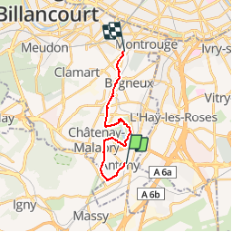
Ruta Senderismo de 13,6 km a descubrir en Isla de Francia, Altos del Sena, Antony. Esta ruta ha sido propuesta por tracegps.
Descripción
Départ à la gare RER d'Antony, arrivée au métro Chatillon Montrouge. Parcours sur la Coulée Verte avec de grands détours dans le Parc Heller et le Parc de Sceaux. Daniel Baijot - danielyvesbaijot (at)yahoo.fr
Localización
País:
France
Región :
Isla de Francia
Departamento/provincia :
Altos del Sena
Municipio :
Antony
Localidad:
Unknown
Salida:(Dec)
Salida:(UTM)
448623 ; 5400400 (31U) N.
Comentarios
Excursiones cerca
![Excursión Senderismo Verrières-le-Buisson - Sur les sentiers de découverte du Bois de Verrières - Photo](https://media.geolcdn.com/t/375/260/ext.jpg?maxdim=2&url=https%3A%2F%2Fservices.sitytrail.com%2FGeolivesWS%2FDownloadMedia.ashx%3FTrailID%3D110232%26Media%3D5500_1.jpg)
![Senderismo Senderismo](https://static1.geolcdn.com/sitytour/trail-icons/101.png)
Sur les sentiers de découverte du Bois de Verrières
Senderismo
Medio
(2)
Verrières-le-Buisson,
Isla de Francia,
Essonne,
France
![](/images/other/stat-length.png)
22 km | 27 km-effort
4h 40min
![](https://static1.geolcdn.com/siteimages/upload/files/16400158638029165_repeat_loop_refresh_sync_direction_icon.png)
Sí
![Excursión Senderismo Sceaux - Les Hauts de Bièvre - Photo](https://media.geolcdn.com/t/375/260/ext.jpg?maxdim=2&url=https%3A%2F%2Fservices.sitytrail.com%2FGeolivesWS%2FDownloadMedia.ashx%3FTrailID%3D110019%26Media%3D5127_1.jpg)
![Senderismo Senderismo](https://static1.geolcdn.com/sitytour/trail-icons/101.png)
Les Hauts de Bièvre
Senderismo
Difícil
(2)
Sceaux,
Isla de Francia,
Altos del Sena,
France
![](/images/other/stat-length.png)
25 km | 30 km-effort
6h 0min
![](https://static1.geolcdn.com/siteimages/upload/files/16400158638029165_repeat_loop_refresh_sync_direction_icon.png)
Sí
![Excursión Senderismo Fontenay-aux-Roses - Rando des 3 Parcs ! (des Gares RER) - Photo](https://media.geolcdn.com/t/375/260/ext.jpg?maxdim=2&url=https%3A%2F%2Fstatic1.geolcdn.com%2Fsiteimages%2Fupload%2Ffiles%2F1553511878bg_sport_marche.png)
![Senderismo Senderismo](https://static1.geolcdn.com/sitytour/trail-icons/101.png)
Rando des 3 Parcs ! (des Gares RER)
Senderismo
Muy difícil
(2)
Fontenay-aux-Roses,
Isla de Francia,
Altos del Sena,
France
![](/images/other/stat-length.png)
15,9 km | 19,5 km-effort
4h 26min
![](https://static1.geolcdn.com/siteimages/upload/files/16400158638029165_repeat_loop_refresh_sync_direction_icon.png)
No
![Excursión A pie Antony - Sur la Rive Gauche de la Bièvre - Photo](https://media.geolcdn.com/t/375/260/ext.jpg?maxdim=2&url=https%3A%2F%2Fmedia.geolcdn.com%2Ff%2F2c3929b8-0b44-4788-adde-07756b1afabd.jpeg)
![A pie A pie](https://static1.geolcdn.com/sitytour/trail-icons/100.png)
Sur la Rive Gauche de la Bièvre
A pie
Fácil
Antony,
Isla de Francia,
Altos del Sena,
France
![](/images/other/stat-length.png)
5 km | 6,2 km-effort
1h 24min
![](https://static1.geolcdn.com/siteimages/upload/files/16400158638029165_repeat_loop_refresh_sync_direction_icon.png)
No
![Excursión Senderismo Clamart - Tour des etangs - Bois de Clamart et de Meudon - Photo](https://media.geolcdn.com/t/375/260/ext.jpg?maxdim=2&url=https%3A%2F%2Fmedia.geolcdn.com%2Ff%2F95237daa-2f69-4622-acc2-897839c78a72.jpg)
![Senderismo Senderismo](https://static1.geolcdn.com/sitytour/trail-icons/101.png)
Tour des etangs - Bois de Clamart et de Meudon
Senderismo
Fácil
Clamart,
Isla de Francia,
Altos del Sena,
France
![](/images/other/stat-length.png)
8 km | 9,9 km-effort
2h 16min
![](https://static1.geolcdn.com/siteimages/upload/files/16400158638029165_repeat_loop_refresh_sync_direction_icon.png)
Sí
![Excursión Senderismo Antony - De gare à gare - Photo](https://media.geolcdn.com/t/375/260/ext.jpg?maxdim=2&url=https%3A%2F%2Fstatic1.geolcdn.com%2Fsiteimages%2Fupload%2Ffiles%2F1553511878bg_sport_marche.png)
![Senderismo Senderismo](https://static1.geolcdn.com/sitytour/trail-icons/101.png)
De gare à gare
Senderismo
Fácil
(1)
Antony,
Isla de Francia,
Altos del Sena,
France
![](/images/other/stat-length.png)
6,4 km | 7,2 km-effort
1h 29min
![](https://static1.geolcdn.com/siteimages/upload/files/16400158638029165_repeat_loop_refresh_sync_direction_icon.png)
No
![Excursión Senderismo Sceaux - Sur les pas de Châteaubriant - Photo](https://media.geolcdn.com/t/375/260/ext.jpg?maxdim=2&url=https%3A%2F%2Fmedia.geolcdn.com%2Ff%2F6464ca19-73f5-4fbc-8f49-a3821d0ff0dc.jpg)
![Senderismo Senderismo](https://static1.geolcdn.com/sitytour/trail-icons/101.png)
Sur les pas de Châteaubriant
Senderismo
Medio
Sceaux,
Isla de Francia,
Altos del Sena,
France
![](/images/other/stat-length.png)
16,7 km | 20 km-effort
4h 33min
![](https://static1.geolcdn.com/siteimages/upload/files/16400158638029165_repeat_loop_refresh_sync_direction_icon.png)
Sí
![Excursión Senderismo Bagneux - Chatillon - Photo](https://media.geolcdn.com/t/375/260/ext.jpg?maxdim=2&url=https%3A%2F%2Fmedia.geolcdn.com%2Ff%2Fca0c0ced-ef16-4ead-9352-c2531a0f1ae6.jpg)
![Senderismo Senderismo](https://static1.geolcdn.com/sitytour/trail-icons/101.png)
Chatillon
Senderismo
Fácil
Bagneux,
Isla de Francia,
Altos del Sena,
France
![](/images/other/stat-length.png)
13,7 km | 16 km-effort
3h 31min
![](https://static1.geolcdn.com/siteimages/upload/files/16400158638029165_repeat_loop_refresh_sync_direction_icon.png)
Sí
![Excursión Senderismo Palaiseau - La Troche - Photo](https://media.geolcdn.com/t/375/260/ext.jpg?maxdim=2&url=https%3A%2F%2Fmedia.geolcdn.com%2Ff%2F1b039b30-c7b2-485c-956b-2208f3a33ce0.jpg)
![Senderismo Senderismo](https://static1.geolcdn.com/sitytour/trail-icons/101.png)
La Troche
Senderismo
Muy difícil
Palaiseau,
Isla de Francia,
Essonne,
France
![](/images/other/stat-length.png)
16,5 km | 20 km-effort
4h 33min
![](https://static1.geolcdn.com/siteimages/upload/files/16400158638029165_repeat_loop_refresh_sync_direction_icon.png)
No