![](/images/other/stat-length.png)
![Excursión Senderismo Bost - Les Gouttes Noires - Bost - Photo](https://media.geolcdn.com/t/1900/400/ext.pjpeg?maxdim=2&url=https%3A%2F%2Fservices.sitytrail.com%2FGeolivesWS%2FDownloadMedia.ashx%3FTrailID%3D106560%26Media%3D11131_5.jpg)
Les Gouttes Noires - Bost
tracegps
Usuario
![Longitud](/images/other/stat-length.png)
Longitud
14,4 km
![Altitud máxima](https://static1.geolcdn.com/siteimages/upload/files/1508320355ic_sort_altitude_max_24dp.png)
Altitud máxima
481 m
![Desnivel positivo](https://static1.geolcdn.com/siteimages/upload/files/1508320355ic_sort_den_pos_24dp.png)
Desnivel positivo
304 m
![Km-Effort](/images/other/stat-length.png)
Km-Effort
18,4 km
![Altitud mínima](https://static1.geolcdn.com/siteimages/upload/files/1508320355ic_sort_altitude_min_24dp.png)
Altitud mínima
269 m
![Desnivel negativo](https://static1.geolcdn.com/siteimages/upload/files/1508320355ic_sort_den_neg_24dp.png)
Desnivel negativo
304 m
![Boucle](https://static1.geolcdn.com/siteimages/upload/files/16400158638029165_repeat_loop_refresh_sync_direction_icon.png)
Boucle
Sí
Fecha de creación :
2014-12-10 00:00:00.0
Última modificación :
2014-12-10 00:00:00.0
![Senderismo](https://static1.geolcdn.com/sitytour/trail-icons/101.png)
3h34
Dificultad : Medio
![Escanee este código QR para abrir la excursión en la aplicación SityTrail](https://capi.geolives.com/qq0zvz2zws4bq2lad0pu/sitytour/trails/106560/qr.png?size=200)
Aplicación GPS de excursión GRATIS
A propósito
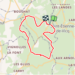
Ruta Senderismo de 14,4 km a descubrir en Auvergne-Rhône-Alpes, Allier, Bost. Esta ruta ha sido propuesta por tracegps.
Descripción
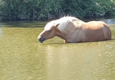
La douceur et la beauté des vues et du patrimoine bâti récompensent les efforts! Vues sur la montagne Bourbonnaise, à travers le bois de Celsat et le hameau des Acarins.
Localización
País:
France
Región :
Auvergne-Rhône-Alpes
Departamento/provincia :
Allier
Municipio :
Bost
Localidad:
Unknown
Salida:(Dec)
Salida:(UTM)
539944 ; 5114026 (31T) N.
Comentarios
Excursiones cerca
![Excursión Senderismo Bost - AVF reconnaissance Bost - Photo](https://media.geolcdn.com/t/375/260/ext.jpg?maxdim=2&url=https%3A%2F%2Fstatic1.geolcdn.com%2Fsiteimages%2Fupload%2Ffiles%2F1553511878bg_sport_marche.png)
![Senderismo Senderismo](https://static1.geolcdn.com/sitytour/trail-icons/101.png)
AVF reconnaissance Bost
Senderismo
Difícil
Bost,
Auvergne-Rhône-Alpes,
Allier,
France
![](/images/other/stat-length.png)
9,9 km | 11,7 km-effort
2h 52min
![](https://static1.geolcdn.com/siteimages/upload/files/16400158638029165_repeat_loop_refresh_sync_direction_icon.png)
Sí
![Excursión Senderismo Bost - bost bof - Photo](https://media.geolcdn.com/t/375/260/2ea7e5ba-20ed-4199-8b96-a4e8082f4455.jpg&format=jpg&maxdim=2)
![Senderismo Senderismo](https://static1.geolcdn.com/sitytour/trail-icons/101.png)
bost bof
Senderismo
Medio
Bost,
Auvergne-Rhône-Alpes,
Allier,
France
![](/images/other/stat-length.png)
13,5 km | 17,4 km-effort
3h 43min
![](https://static1.geolcdn.com/siteimages/upload/files/16400158638029165_repeat_loop_refresh_sync_direction_icon.png)
Sí
![Excursión Senderismo Bost - Randonnée, Les, goutte Noire, Vichy, 2023 - Photo](https://media.geolcdn.com/t/375/260/ext.jpg?maxdim=2&url=https%3A%2F%2Fstatic1.geolcdn.com%2Fsiteimages%2Fupload%2Ffiles%2F1553511878bg_sport_marche.png)
![Senderismo Senderismo](https://static1.geolcdn.com/sitytour/trail-icons/101.png)
Randonnée, Les, goutte Noire, Vichy, 2023
Senderismo
Medio
Bost,
Auvergne-Rhône-Alpes,
Allier,
France
![](/images/other/stat-length.png)
7,1 km | 9,7 km-effort
1h 45min
![](https://static1.geolcdn.com/siteimages/upload/files/16400158638029165_repeat_loop_refresh_sync_direction_icon.png)
Sí
![Excursión Senderismo Saint-Étienne-de-Vicq - La Bruyère - Saint Christophe - Photo](https://media.geolcdn.com/t/375/260/ext.jpg?maxdim=2&url=https%3A%2F%2Fstatic1.geolcdn.com%2Fsiteimages%2Fupload%2Ffiles%2F1553511878bg_sport_marche.png)
![Senderismo Senderismo](https://static1.geolcdn.com/sitytour/trail-icons/101.png)
La Bruyère - Saint Christophe
Senderismo
Muy difícil
Saint-Étienne-de-Vicq,
Auvergne-Rhône-Alpes,
Allier,
France
![](/images/other/stat-length.png)
17,4 km | 22 km-effort
4h 46min
![](https://static1.geolcdn.com/siteimages/upload/files/16400158638029165_repeat_loop_refresh_sync_direction_icon.png)
Sí
![Excursión Otra actividad Saint-Étienne-de-Vicq - st etienne de vicq - Photo](https://media.geolcdn.com/t/375/260/ext.jpg?maxdim=2&url=https%3A%2F%2Fstatic1.geolcdn.com%2Fsiteimages%2Fupload%2Ffiles%2F1545311037marcheuse_200dpi.jpg)
![Otra actividad Otra actividad](https://static1.geolcdn.com/sitytour/trail-icons/900.png)
st etienne de vicq
Otra actividad
Muy fácil
Saint-Étienne-de-Vicq,
Auvergne-Rhône-Alpes,
Allier,
France
![](/images/other/stat-length.png)
12,6 km | 16,7 km-effort
3h 14min
![](https://static1.geolcdn.com/siteimages/upload/files/16400158638029165_repeat_loop_refresh_sync_direction_icon.png)
Sí
![Excursión Otra actividad Saint-Étienne-de-Vicq - st etienn'e - Photo](https://media.geolcdn.com/t/375/260/ext.jpg?maxdim=2&url=https%3A%2F%2Fstatic1.geolcdn.com%2Fsiteimages%2Fupload%2Ffiles%2F1545311037marcheuse_200dpi.jpg)
![Otra actividad Otra actividad](https://static1.geolcdn.com/sitytour/trail-icons/900.png)
st etienn'e
Otra actividad
Muy fácil
Saint-Étienne-de-Vicq,
Auvergne-Rhône-Alpes,
Allier,
France
![](/images/other/stat-length.png)
11,9 km | 13,7 km-effort
2h 51min
![](https://static1.geolcdn.com/siteimages/upload/files/16400158638029165_repeat_loop_refresh_sync_direction_icon.png)
Sí