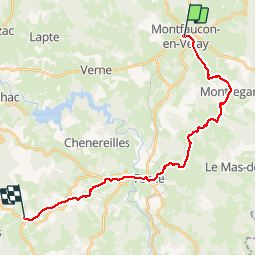
![](/images/other/stat-length.png)
![Excursión Senderismo Montfaucon-en-Velay - Chemin de Saint Régis: Montfaucon en Velay - Saint Jeures - Photo](https://media.geolcdn.com/t/1900/400/ext.pjpeg?maxdim=2&url=https%3A%2F%2Fservices.sitytrail.com%2FGeolivesWS%2FDownloadMedia.ashx%3FTrailID%3D106328%26Media%3D10776_1.jpg)
Chemin de Saint Régis: Montfaucon en Velay - Saint Jeures
tracegps
Usuario
![Longitud](/images/other/stat-length.png)
![Altitud máxima](https://static1.geolcdn.com/siteimages/upload/files/1508320355ic_sort_altitude_max_24dp.png)
![Desnivel positivo](https://static1.geolcdn.com/siteimages/upload/files/1508320355ic_sort_den_pos_24dp.png)
![Km-Effort](/images/other/stat-length.png)
![Altitud mínima](https://static1.geolcdn.com/siteimages/upload/files/1508320355ic_sort_altitude_min_24dp.png)
![Desnivel negativo](https://static1.geolcdn.com/siteimages/upload/files/1508320355ic_sort_den_neg_24dp.png)
![Boucle](https://static1.geolcdn.com/siteimages/upload/files/16400158638029165_repeat_loop_refresh_sync_direction_icon.png)
![Senderismo](https://static1.geolcdn.com/sitytour/trail-icons/101.png)
6h45
Dificultad : Medio
![Escanee este código QR para abrir la excursión en la aplicación SityTrail](https://capi.geolives.com/qq0zvz2zws4bq2lad0pu/sitytour/trails/106328/qr.png?size=200)
Aplicación GPS de excursión GRATIS
A propósito
Ruta Senderismo de 22 km a descubrir en Auvergne-Rhône-Alpes, Alto Loira, Montfaucon-en-Velay. Esta ruta ha sido propuesta por tracegps.
Descripción
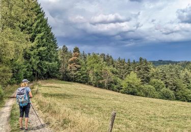
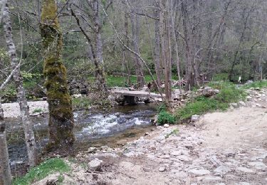
Chemin de Saint Régis: Montfaucon en Velay – Saint Jeures Cette étape et la précédente se tissent avec le chemin de Compostelle qui draine des pèlerins suisses se rendant au Puy. Je traverse des paysages vallonnés de prairies parsemées de maisons isolées et de minuscules villages. A Montregard, je dois chercher pendant un moment la statue de Saint Régis qui surplombe le village du Château mais se cache du promeneur. Au pied du saint homme de métal rouillé, on devrait embrasser un large panorama, mais le temps brumeux brouille l’horizon et estompe le relief. Avant Tence, on traverse un éden miniature, véritable cliché de carte postale : un petit pont de bois jeté sur un ruisseau turbulent serpentant au milieu de champs de jonquilles où paissent des vaches nonchalantes… La suite du récit est ICI.
Localización
Comentarios
Excursiones cerca
![Excursión Bici de montaña Montregard - Espace VTT FFC Le Velay des 3 Rivières - N°15 Le Ruisseau de Trifoulou Montregard - Photo](https://media.geolcdn.com/t/375/260/ext.jpg?maxdim=2&url=https%3A%2F%2Fservices.sitytrail.com%2FGeolivesWS%2FDownloadMedia.ashx%3FTrailID%3D101816%26Media%3D2091_1.jpg)
![Bici de montaña Bici de montaña](https://static1.geolcdn.com/sitytour/trail-icons/202.png)
Bici de montaña
![](/images/other/stat-length.png)
![](https://static1.geolcdn.com/siteimages/upload/files/16400158638029165_repeat_loop_refresh_sync_direction_icon.png)
![Excursión Senderismo Montregard - Rando t'est - Photo](https://media.geolcdn.com/t/375/260/d3922d2c-6cda-4628-a70a-b81ba71a6ff8.jpg&format=jpg&maxdim=2)
![Senderismo Senderismo](https://static1.geolcdn.com/sitytour/trail-icons/101.png)
Senderismo
![](/images/other/stat-length.png)
![](https://static1.geolcdn.com/siteimages/upload/files/16400158638029165_repeat_loop_refresh_sync_direction_icon.png)
![Excursión Senderismo Saint-Pal-de-Mons - chapelle ste julien-7 km - Photo](https://media.geolcdn.com/t/375/260/cfa5e2e6-8689-4e6b-80b6-6f81820462e4.jpg&format=jpg&maxdim=2)
![Senderismo Senderismo](https://static1.geolcdn.com/sitytour/trail-icons/101.png)
Senderismo
![](/images/other/stat-length.png)
![](https://static1.geolcdn.com/siteimages/upload/files/16400158638029165_repeat_loop_refresh_sync_direction_icon.png)
![Excursión Senderismo Montfaucon-en-Velay - Jakobsweg 2014-1 - Photo](https://media.geolcdn.com/t/375/260/ext.jpg?maxdim=2&url=https%3A%2F%2Fstatic1.geolcdn.com%2Fsiteimages%2Fupload%2Ffiles%2F1553511878bg_sport_marche.png)
![Senderismo Senderismo](https://static1.geolcdn.com/sitytour/trail-icons/101.png)
Senderismo
![](/images/other/stat-length.png)
![](https://static1.geolcdn.com/siteimages/upload/files/16400158638029165_repeat_loop_refresh_sync_direction_icon.png)
![Excursión Bici de montaña Dunières - voie verte Duniere Tracol - Photo](https://media.geolcdn.com/t/375/260/b6cbb374-58cf-46c7-b98e-163e098670c6.jpg&format=jpg&maxdim=2)
![Bici de montaña Bici de montaña](https://static1.geolcdn.com/sitytour/trail-icons/202.png)
Bici de montaña
![](/images/other/stat-length.png)
![](https://static1.geolcdn.com/siteimages/upload/files/16400158638029165_repeat_loop_refresh_sync_direction_icon.png)
![Excursión Bici de montaña Montfaucon-en-Velay - Via Fluvia de Montfaucon au tunnel de Tracol - Photo](https://media.geolcdn.com/t/375/260/a1305139-c391-4f76-855e-ed9bd97c1e04.jpg&format=jpg&maxdim=2)
![Bici de montaña Bici de montaña](https://static1.geolcdn.com/sitytour/trail-icons/202.png)
Bici de montaña
![](/images/other/stat-length.png)
![](https://static1.geolcdn.com/siteimages/upload/files/16400158638029165_repeat_loop_refresh_sync_direction_icon.png)
![Excursión Senderismo Raucoules - Circuit des Jeannettes - Photo](https://media.geolcdn.com/t/375/260/b5612293-67f6-48d9-b3e5-52deb79c4c3f.jpg&format=jpg&maxdim=2)
![Senderismo Senderismo](https://static1.geolcdn.com/sitytour/trail-icons/101.png)
Senderismo
![](/images/other/stat-length.png)
![](https://static1.geolcdn.com/siteimages/upload/files/16400158638029165_repeat_loop_refresh_sync_direction_icon.png)
![Excursión Senderismo Saint-Pal-de-Mons - La Chapelle St Julien 2017 04 15 - Photo](https://media.geolcdn.com/t/375/260/ext.jpg?maxdim=2&url=https%3A%2F%2Fservices.sitytrail.com%2FGeolivesWS%2FDownloadMedia.ashx%3FTrailID%3D733139%26Media%3Dfix__20170415144318.jpg)
![Senderismo Senderismo](https://static1.geolcdn.com/sitytour/trail-icons/101.png)
Senderismo
![](/images/other/stat-length.png)
![](https://static1.geolcdn.com/siteimages/upload/files/16400158638029165_repeat_loop_refresh_sync_direction_icon.png)
![Excursión Senderismo Saint-Pal-de-Mons - La Chapelle St Julien 2017 04 15 - Photo](https://media.geolcdn.com/t/375/260/ext.jpg?maxdim=2&url=https%3A%2F%2Fservices.sitytrail.com%2FGeolivesWS%2FDownloadMedia.ashx%3FTrailID%3D733134%26Media%3Dfix__20170415144318.jpg)
![Senderismo Senderismo](https://static1.geolcdn.com/sitytour/trail-icons/101.png)
Senderismo
![](/images/other/stat-length.png)
![](https://static1.geolcdn.com/siteimages/upload/files/16400158638029165_repeat_loop_refresh_sync_direction_icon.png)