![](/images/other/stat-length.png)
![Excursión Senderismo Saint-Maurice-sur-Moselle - Etang du Petit Haut - Rivière La Savoureuse - Photo](https://media.geolcdn.com/t/1900/400/ext.pjpeg?maxdim=2&url=https%3A%2F%2Fservices.sitytrail.com%2FGeolivesWS%2FDownloadMedia.ashx%3FTrailID%3D106267%26Media%3D10619_5.jpg)
Etang du Petit Haut - Rivière La Savoureuse
tracegps
Usuario
![Longitud](/images/other/stat-length.png)
Longitud
5,8 km
![Altitud máxima](https://static1.geolcdn.com/siteimages/upload/files/1508320355ic_sort_altitude_max_24dp.png)
Altitud máxima
1172 m
![Desnivel positivo](https://static1.geolcdn.com/siteimages/upload/files/1508320355ic_sort_den_pos_24dp.png)
Desnivel positivo
265 m
![Km-Effort](/images/other/stat-length.png)
Km-Effort
9,4 km
![Altitud mínima](https://static1.geolcdn.com/siteimages/upload/files/1508320355ic_sort_altitude_min_24dp.png)
Altitud mínima
922 m
![Desnivel negativo](https://static1.geolcdn.com/siteimages/upload/files/1508320355ic_sort_den_neg_24dp.png)
Desnivel negativo
265 m
![Boucle](https://static1.geolcdn.com/siteimages/upload/files/16400158638029165_repeat_loop_refresh_sync_direction_icon.png)
Boucle
Sí
Fecha de creación :
2014-12-10 00:00:00.0
Última modificación :
2014-12-10 00:00:00.0
![Senderismo](https://static1.geolcdn.com/sitytour/trail-icons/101.png)
1h30
Dificultad : Medio
![Escanee este código QR para abrir la excursión en la aplicación SityTrail](https://capi.geolives.com/qq0zvz2zws4bq2lad0pu/sitytour/trails/106267/qr.png?size=200)
Aplicación GPS de excursión GRATIS
A propósito
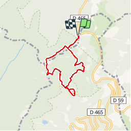
Ruta Senderismo de 5,8 km a descubrir en Gran Este, Vosgos, Saint-Maurice-sur-Moselle. Esta ruta ha sido propuesta por tracegps.
Descripción
Au départ du ballon d'Alsace, une randonnée au fil des cascades qui vous emporte jusqu'au Lac au cœur de la forêt.
Localización
País:
France
Región :
Gran Este
Departamento/provincia :
Vosgos
Municipio :
Saint-Maurice-sur-Moselle
Localidad:
Unknown
Salida:(Dec)
Salida:(UTM)
337909 ; 5298582 (32T) N.
Comentarios
Excursiones cerca
![Excursión Senderismo Saint-Maurice-sur-Moselle - Tour du Ballon d'Alsace - Photo](https://media.geolcdn.com/t/375/260/ext.jpg?maxdim=2&url=https%3A%2F%2Fservices.sitytrail.com%2FGeolivesWS%2FDownloadMedia.ashx%3FTrailID%3D450011%26Media%3Dfix__20150716161020.jpg)
![Senderismo Senderismo](https://static1.geolcdn.com/sitytour/trail-icons/101.png)
Tour du Ballon d'Alsace
Senderismo
Difícil
(1)
Saint-Maurice-sur-Moselle,
Gran Este,
Vosgos,
France
![](/images/other/stat-length.png)
10,5 km | 17,7 km-effort
5h 25min
![](https://static1.geolcdn.com/siteimages/upload/files/16400158638029165_repeat_loop_refresh_sync_direction_icon.png)
Sí
![Excursión Senderismo Sewen - lac d'Alfeld - Photo](https://media.geolcdn.com/t/375/260/f10be3b8-650f-4f78-b860-6c956e66a815.jpg&format=jpg&maxdim=2)
![Senderismo Senderismo](https://static1.geolcdn.com/sitytour/trail-icons/101.png)
lac d'Alfeld
Senderismo
Muy difícil
(1)
Sewen,
Gran Este,
Alto Rin,
France
![](/images/other/stat-length.png)
17,1 km | 28 km-effort
8h 7min
![](https://static1.geolcdn.com/siteimages/upload/files/16400158638029165_repeat_loop_refresh_sync_direction_icon.png)
Sí
![Excursión Senderismo Lepuix - Le Tremontkopf - Photo](https://media.geolcdn.com/t/375/260/ext.jpg?maxdim=2&url=https%3A%2F%2Fservices.sitytrail.com%2FGeolivesWS%2FDownloadMedia.ashx%3FTrailID%3D109649%26Media%3D4290_1.jpg)
![Senderismo Senderismo](https://static1.geolcdn.com/sitytour/trail-icons/101.png)
Le Tremontkopf
Senderismo
Medio
(1)
Lepuix,
Borgoña-Franco Condado,
Territorio de Belfort,
France
![](/images/other/stat-length.png)
9,1 km | 17,3 km-effort
3h 0min
![](https://static1.geolcdn.com/siteimages/upload/files/16400158638029165_repeat_loop_refresh_sync_direction_icon.png)
Sí
![Excursión Senderismo Plancher-les-Mines - Le Ballon de Servance - Photo](https://media.geolcdn.com/t/375/260/ext.jpg?maxdim=2&url=https%3A%2F%2Fservices.sitytrail.com%2FGeolivesWS%2FDownloadMedia.ashx%3FTrailID%3D109643%26Media%3D4284_1.jpg)
![Senderismo Senderismo](https://static1.geolcdn.com/sitytour/trail-icons/101.png)
Le Ballon de Servance
Senderismo
Difícil
(2)
Plancher-les-Mines,
Borgoña-Franco Condado,
Alto Saona,
France
![](/images/other/stat-length.png)
19,7 km | 30 km-effort
6h 0min
![](https://static1.geolcdn.com/siteimages/upload/files/16400158638029165_repeat_loop_refresh_sync_direction_icon.png)
Sí
![Excursión Senderismo Plancher-les-Mines - 2025-01-04 Rando Polaire Dolleren Ballon Alsace Etape 3 - Photo](https://media.geolcdn.com/t/375/260/2540e417-a017-45ca-bf10-302bab8725fa.jpg&format=jpg&maxdim=2)
![Senderismo Senderismo](https://static1.geolcdn.com/sitytour/trail-icons/101.png)
2025-01-04 Rando Polaire Dolleren Ballon Alsace Etape 3
Senderismo
Muy difícil
Plancher-les-Mines,
Borgoña-Franco Condado,
Alto Saona,
France
![](/images/other/stat-length.png)
18,6 km | 30 km-effort
6h 52min
![](https://static1.geolcdn.com/siteimages/upload/files/16400158638029165_repeat_loop_refresh_sync_direction_icon.png)
No
![Excursión Senderismo Dolleren - 2025-01-03 Rando Polaire Dolleren Ballon Alsace Etape 2 - Photo](https://media.geolcdn.com/t/375/260/9acfce3f-2eaf-4a63-8eb3-62065bd107c3.jpg&format=jpg&maxdim=2)
![Senderismo Senderismo](https://static1.geolcdn.com/sitytour/trail-icons/101.png)
2025-01-03 Rando Polaire Dolleren Ballon Alsace Etape 2
Senderismo
Muy difícil
Dolleren,
Gran Este,
Alto Rin,
France
![](/images/other/stat-length.png)
17,3 km | 26 km-effort
6h 0min
![](https://static1.geolcdn.com/siteimages/upload/files/16400158638029165_repeat_loop_refresh_sync_direction_icon.png)
No
![Bici de montaña Bici de montaña](https://static1.geolcdn.com/sitytour/trail-icons/202.png)
SityTrail - 3248441 - documentxix745004916x3256137
Bici de montaña
Medio
Saint-Maurice-sur-Moselle,
Gran Este,
Vosgos,
France
![](/images/other/stat-length.png)
21 km | 30 km-effort
2h 3min
![](https://static1.geolcdn.com/siteimages/upload/files/16400158638029165_repeat_loop_refresh_sync_direction_icon.png)
Sí
![Excursión Senderismo Servance-Miellin - 2019-08-06 Marche Ballon Servance Ballon Alsace - Photo](https://media.geolcdn.com/t/375/260/452d83b8-7651-47fa-bbef-bff585b94030.jpg&format=jpg&maxdim=2)
![Senderismo Senderismo](https://static1.geolcdn.com/sitytour/trail-icons/101.png)
2019-08-06 Marche Ballon Servance Ballon Alsace
Senderismo
Muy difícil
Servance-Miellin,
Borgoña-Franco Condado,
Alto Saona,
France
![](/images/other/stat-length.png)
19,9 km | 31 km-effort
6h 23min
![](https://static1.geolcdn.com/siteimages/upload/files/16400158638029165_repeat_loop_refresh_sync_direction_icon.png)
Sí
![Excursión Senderismo Saint-Maurice-sur-Moselle - le lac des roseaux - Photo](https://media.geolcdn.com/t/375/260/ext.jpg?maxdim=2&url=https%3A%2F%2Fservices.sitytrail.com%2FGeolivesWS%2FDownloadMedia.ashx%3FTrailID%3D489792%26Media%3D455bc21e-67b8-4bf5-be66-0e90e9e8ca9a.jpg)
![Senderismo Senderismo](https://static1.geolcdn.com/sitytour/trail-icons/101.png)
le lac des roseaux
Senderismo
Medio
Saint-Maurice-sur-Moselle,
Gran Este,
Vosgos,
France
![](/images/other/stat-length.png)
11,1 km | 17,6 km-effort
3h 35min
![](https://static1.geolcdn.com/siteimages/upload/files/16400158638029165_repeat_loop_refresh_sync_direction_icon.png)
No