![](/images/other/stat-length.png)
![Excursión Caballo Ruaudin - Circuit des Bondes - Ruaudin - Photo](https://media.geolcdn.com/t/1900/400/ext.pjpeg?maxdim=2&url=https%3A%2F%2Fservices.sitytrail.com%2FGeolivesWS%2FDownloadMedia.ashx%3FTrailID%3D106203%26Media%3D10492_4.jpg)
Circuit des Bondes - Ruaudin
tracegps
Usuario
![Longitud](/images/other/stat-length.png)
Longitud
12,9 km
![Altitud máxima](https://static1.geolcdn.com/siteimages/upload/files/1508320355ic_sort_altitude_max_24dp.png)
Altitud máxima
76 m
![Desnivel positivo](https://static1.geolcdn.com/siteimages/upload/files/1508320355ic_sort_den_pos_24dp.png)
Desnivel positivo
88 m
![Km-Effort](/images/other/stat-length.png)
Km-Effort
14,1 km
![Altitud mínima](https://static1.geolcdn.com/siteimages/upload/files/1508320355ic_sort_altitude_min_24dp.png)
Altitud mínima
50 m
![Desnivel negativo](https://static1.geolcdn.com/siteimages/upload/files/1508320355ic_sort_den_neg_24dp.png)
Desnivel negativo
88 m
![Boucle](https://static1.geolcdn.com/siteimages/upload/files/16400158638029165_repeat_loop_refresh_sync_direction_icon.png)
Boucle
Sí
Fecha de creación :
2014-12-10 00:00:00.0
Última modificación :
2014-12-10 00:00:00.0
![Caballo](https://static1.geolcdn.com/sitytour/trail-icons/300.png)
2h19
Dificultad : Medio
![Escanee este código QR para abrir la excursión en la aplicación SityTrail](https://capi.geolives.com/qq0zvz2zws4bq2lad0pu/sitytour/trails/106203/qr.png?size=200)
Aplicación GPS de excursión GRATIS
A propósito
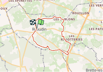
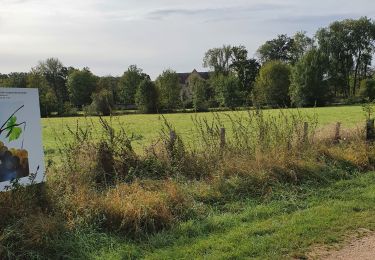
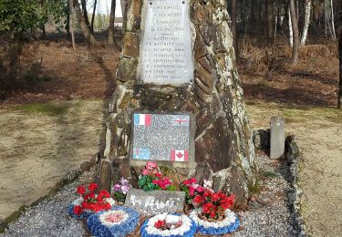
Ruta Caballo de 12,9 km a descubrir en Países del Loira, Sarthe, Ruaudin. Esta ruta ha sido propuesta por tracegps.
Descripción
Circuit proposé par la commune de Ruaudin. Départ du parking de l'église de Ruaudin. Retrouvez le circuit sur le site de la commune de Ruaudin.
Localización
País:
France
Región :
Países del Loira
Departamento/provincia :
Sarthe
Municipio :
Ruaudin
Localidad:
Unknown
Salida:(Dec)
Salida:(UTM)
295713 ; 5313682 (31T) N.
Comentarios
Excursiones cerca
![Excursión Bici de montaña Changé - Boucle Le Mans - Changé - Brettes - Parigné - Challes 53 km - Photo](https://media.geolcdn.com/t/375/260/ext.jpg?maxdim=2&url=https%3A%2F%2Fservices.sitytrail.com%2FGeolivesWS%2FDownloadMedia.ashx%3FTrailID%3D172382%26Media%3D13727_1.jpg)
![Bici de montaña Bici de montaña](https://static1.geolcdn.com/sitytour/trail-icons/202.png)
Boucle Le Mans - Changé - Brettes - Parigné - Challes 53 km
Bici de montaña
Medio
(2)
Changé,
Países del Loira,
Sarthe,
France
![](/images/other/stat-length.png)
53 km | 60 km-effort
2h 30min
![](https://static1.geolcdn.com/siteimages/upload/files/16400158638029165_repeat_loop_refresh_sync_direction_icon.png)
No
![Excursión Bici de montaña Ruaudin - Circuit des Bondes - Ruaudin - Photo](https://media.geolcdn.com/t/375/260/ext.jpg?maxdim=2&url=https%3A%2F%2Fservices.sitytrail.com%2FGeolivesWS%2FDownloadMedia.ashx%3FTrailID%3D106202%26Media%3D10492_4.jpg)
![Bici de montaña Bici de montaña](https://static1.geolcdn.com/sitytour/trail-icons/202.png)
Circuit des Bondes - Ruaudin
Bici de montaña
Medio
Ruaudin,
Países del Loira,
Sarthe,
France
![](/images/other/stat-length.png)
12,9 km | 14,1 km-effort
1h 45min
![](https://static1.geolcdn.com/siteimages/upload/files/16400158638029165_repeat_loop_refresh_sync_direction_icon.png)
Sí
![Excursión Senderismo Ruaudin - Circuit des Bondes - Ruaudin - Photo](https://media.geolcdn.com/t/375/260/ext.jpg?maxdim=2&url=https%3A%2F%2Fservices.sitytrail.com%2FGeolivesWS%2FDownloadMedia.ashx%3FTrailID%3D106201%26Media%3D10492_4.jpg)
![Senderismo Senderismo](https://static1.geolcdn.com/sitytour/trail-icons/101.png)
Circuit des Bondes - Ruaudin
Senderismo
Difícil
(4)
Ruaudin,
Países del Loira,
Sarthe,
France
![](/images/other/stat-length.png)
12,9 km | 14,1 km-effort
3h 15min
![](https://static1.geolcdn.com/siteimages/upload/files/16400158638029165_repeat_loop_refresh_sync_direction_icon.png)
Sí
![Excursión sport Changé - 2024-01-20_22h44m29_exp_13-01-24_traces - Photo](https://media.geolcdn.com/t/375/260/ext.jpg?maxdim=2&url=https%3A%2F%2Fsecurestorage.geolives.com%2Fsitytour%2Ftrail-bg%2Fdefault.jpg)
2024-01-20_22h44m29_exp_13-01-24_traces
sport
Muy fácil
(1)
Changé,
Países del Loira,
Sarthe,
France
![](/images/other/stat-length.png)
36 km | 42 km-effort
Desconocido
![](https://static1.geolcdn.com/siteimages/upload/files/16400158638029165_repeat_loop_refresh_sync_direction_icon.png)
No
![Excursión sport Changé - 2024-01-12_13h36m15_exp_10-01-24_traces - Photo](https://media.geolcdn.com/t/375/260/ext.jpg?maxdim=2&url=https%3A%2F%2Fsecurestorage.geolives.com%2Fsitytour%2Ftrail-bg%2Fdefault.jpg)
2024-01-12_13h36m15_exp_10-01-24_traces
sport
Muy fácil
Changé,
Países del Loira,
Sarthe,
France
![](/images/other/stat-length.png)
36 km | 42 km-effort
Desconocido
![](https://static1.geolcdn.com/siteimages/upload/files/16400158638029165_repeat_loop_refresh_sync_direction_icon.png)
Sí
![Excursión Bicicleta híbrida Changé - reco le mans sept 2021 - Photo](https://media.geolcdn.com/t/375/260/e04116a1-4473-42b8-850e-ac7426d645c6.jpg&format=jpg&maxdim=2)
![Bicicleta híbrida Bicicleta híbrida](https://static1.geolcdn.com/sitytour/trail-icons/203.png)
reco le mans sept 2021
Bicicleta híbrida
Fácil
Changé,
Países del Loira,
Sarthe,
France
![](/images/other/stat-length.png)
15,4 km | 17 km-effort
1h 38min
![](https://static1.geolcdn.com/siteimages/upload/files/16400158638029165_repeat_loop_refresh_sync_direction_icon.png)
No
![Excursión Senderismo Mulsanne - Marche a pied - Photo](https://media.geolcdn.com/t/375/260/5ef32b5e-c4b8-432e-ac82-e2f5840abe7a.jpg&format=jpg&maxdim=2)
![Senderismo Senderismo](https://static1.geolcdn.com/sitytour/trail-icons/101.png)
Marche a pied
Senderismo
Muy fácil
Mulsanne,
Países del Loira,
Sarthe,
France
![](/images/other/stat-length.png)
11,9 km | 13,4 km-effort
2h 46min
![](https://static1.geolcdn.com/siteimages/upload/files/16400158638029165_repeat_loop_refresh_sync_direction_icon.png)
Sí
![Excursión Senderismo Changé - grand tour des bois de changé le Mans - Photo](https://media.geolcdn.com/t/375/260/ext.jpg?maxdim=2&url=https%3A%2F%2Fstatic1.geolcdn.com%2Fsiteimages%2Fupload%2Ffiles%2F1553511878bg_sport_marche.png)
![Senderismo Senderismo](https://static1.geolcdn.com/sitytour/trail-icons/101.png)
grand tour des bois de changé le Mans
Senderismo
Muy fácil
Changé,
Países del Loira,
Sarthe,
France
![](/images/other/stat-length.png)
11,9 km | 13,6 km-effort
2h 45min
![](https://static1.geolcdn.com/siteimages/upload/files/16400158638029165_repeat_loop_refresh_sync_direction_icon.png)
Sí
![Excursión Senderismo Changé - des Chalottières aux Perdrielles - Photo](https://media.geolcdn.com/t/375/260/ext.jpg?maxdim=2&url=https%3A%2F%2Fstatic1.geolcdn.com%2Fsiteimages%2Fupload%2Ffiles%2F1553511878bg_sport_marche.png)
![Senderismo Senderismo](https://static1.geolcdn.com/sitytour/trail-icons/101.png)
des Chalottières aux Perdrielles
Senderismo
Muy fácil
Changé,
Países del Loira,
Sarthe,
France
![](/images/other/stat-length.png)
4,2 km | 4,8 km-effort
1h 4min
![](https://static1.geolcdn.com/siteimages/upload/files/16400158638029165_repeat_loop_refresh_sync_direction_icon.png)
No