


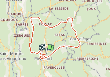

17,9 km | 23 km-effort

Usuario


Aplicación GPS de excursión GRATIS
 SityTrail
IGN / Institutos geográficos
SityTrail World
El mundo es suyo
Ruta Senderismo de 17,9 km a descubrir en Auvergne-Rhône-Alpes, Cantal, Pierrefort. Esta ruta ha sido propuesta por tracegps.
Circuit partant de Pierrefort (15), très facile, chemin en sable et petits cailloux, quelques petites routes à traverser, des bois (Chabridet et Montrosier), chemin bien large, on ne peut pas le perdre.


Caballo
Bici de montaña

Senderismo
Senderismo
Senderismo
Senderismo
Senderismo
Senderismo

Bici eléctrica