![](/images/other/stat-length.png)
![Excursión Senderismo Saint-André-en-Morvan - Saint André en Morvan - Photo](https://media.geolcdn.com/t/1900/400/ext.pjpeg?maxdim=2&url=https%3A%2F%2Fstatic1.geolcdn.com%2Fsiteimages%2Fupload%2Ffiles%2F1553511878bg_sport_marche.png)
Saint André en Morvan
tracegps
Usuario
![Longitud](/images/other/stat-length.png)
Longitud
10,9 km
![Altitud máxima](https://static1.geolcdn.com/siteimages/upload/files/1508320355ic_sort_altitude_max_24dp.png)
Altitud máxima
369 m
![Desnivel positivo](https://static1.geolcdn.com/siteimages/upload/files/1508320355ic_sort_den_pos_24dp.png)
Desnivel positivo
297 m
![Km-Effort](/images/other/stat-length.png)
Km-Effort
14,9 km
![Altitud mínima](https://static1.geolcdn.com/siteimages/upload/files/1508320355ic_sort_altitude_min_24dp.png)
Altitud mínima
245 m
![Desnivel negativo](https://static1.geolcdn.com/siteimages/upload/files/1508320355ic_sort_den_neg_24dp.png)
Desnivel negativo
292 m
![Boucle](https://static1.geolcdn.com/siteimages/upload/files/16400158638029165_repeat_loop_refresh_sync_direction_icon.png)
Boucle
Sí
Fecha de creación :
2014-12-10 00:00:00.0
Última modificación :
2014-12-10 00:00:00.0
![Senderismo](https://static1.geolcdn.com/sitytour/trail-icons/101.png)
3h00
Dificultad : Difícil
![Escanee este código QR para abrir la excursión en la aplicación SityTrail](https://capi.geolives.com/qq0zvz2zws4bq2lad0pu/sitytour/trails/105691/qr.png?size=200)
Aplicación GPS de excursión GRATIS
A propósito
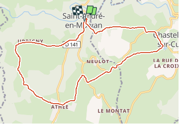
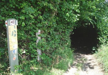
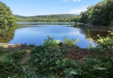
Ruta Senderismo de 10,9 km a descubrir en Borgoña-Franco Condado, Nièvre, Saint-André-en-Morvan. Esta ruta ha sido propuesta por tracegps.
Descripción
Découverte de la Cure et du village où séjourna le peintre Corot. Certaines de ses toiles représentent le village et ses alentours et la vie des habitants.
Localización
País:
France
Región :
Borgoña-Franco Condado
Departamento/provincia :
Nièvre
Municipio :
Saint-André-en-Morvan
Localidad:
Unknown
Salida:(Dec)
Salida:(UTM)
564728 ; 5249128 (31T) N.
Comentarios
Excursiones cerca
![Excursión Senderismo Saint-André-en-Morvan - SAINT-ANDRE-EN-MORVAN (9/20) - Photo](https://media.geolcdn.com/t/375/260/2afd1577-a731-4de7-8e6f-0fb7b3dcf911.jpg&format=jpg&maxdim=2)
![Senderismo Senderismo](https://static1.geolcdn.com/sitytour/trail-icons/101.png)
SAINT-ANDRE-EN-MORVAN (9/20)
Senderismo
Medio
Saint-André-en-Morvan,
Borgoña-Franco Condado,
Nièvre,
France
![](/images/other/stat-length.png)
8,9 km | 11,8 km-effort
3h 15min
![](https://static1.geolcdn.com/siteimages/upload/files/16400158638029165_repeat_loop_refresh_sync_direction_icon.png)
Sí
![Excursión Senderismo Chastellux-sur-Cure - Le Tour du Morvan pédestre - Photo](https://media.geolcdn.com/t/375/260/ext.jpg?maxdim=2&url=https%3A%2F%2Fservices.sitytrail.com%2FGeolivesWS%2FDownloadMedia.ashx%3FTrailID%3D105875%26Media%3D9854_3.jpg)
![Senderismo Senderismo](https://static1.geolcdn.com/sitytour/trail-icons/101.png)
Le Tour du Morvan pédestre
Senderismo
Difícil
Chastellux-sur-Cure,
Borgoña-Franco Condado,
Yonne,
France
![](/images/other/stat-length.png)
265 km | 366 km-effort
125h 0min
![](https://static1.geolcdn.com/siteimages/upload/files/16400158638029165_repeat_loop_refresh_sync_direction_icon.png)
No
![Excursión Senderismo Bazoches - BAZOCHES - (9/20) - Photo](https://media.geolcdn.com/t/375/260/311c8b98-292f-4397-a886-c9a8ef5e96fd.jpg&format=jpg&maxdim=2)
![Senderismo Senderismo](https://static1.geolcdn.com/sitytour/trail-icons/101.png)
BAZOCHES - (9/20)
Senderismo
Medio
Bazoches,
Borgoña-Franco Condado,
Nièvre,
France
![](/images/other/stat-length.png)
10,7 km | 15 km-effort
3h 43min
![](https://static1.geolcdn.com/siteimages/upload/files/16400158638029165_repeat_loop_refresh_sync_direction_icon.png)
Sí
![Excursión Senderismo Bazoches - Autour de Vauban - Bazoches - Photo](https://media.geolcdn.com/t/375/260/ext.jpg?maxdim=2&url=https%3A%2F%2Fservices.sitytrail.com%2FGeolivesWS%2FDownloadMedia.ashx%3FTrailID%3D105713%26Media%3D9558_2.jpg)
![Senderismo Senderismo](https://static1.geolcdn.com/sitytour/trail-icons/101.png)
Autour de Vauban - Bazoches
Senderismo
Medio
(1)
Bazoches,
Borgoña-Franco Condado,
Nièvre,
France
![](/images/other/stat-length.png)
11,1 km | 15,5 km-effort
3h 10min
![](https://static1.geolcdn.com/siteimages/upload/files/16400158638029165_repeat_loop_refresh_sync_direction_icon.png)
Sí
![Excursión Senderismo Marigny-l'Église - Marigny-l'Église et le Lac du Crescent - Photo](https://media.geolcdn.com/t/375/260/ext.jpg?maxdim=2&url=https%3A%2F%2Fservices.sitytrail.com%2FGeolivesWS%2FDownloadMedia.ashx%3FTrailID%3D105649%26Media%3D9451_2.jpg)
![Senderismo Senderismo](https://static1.geolcdn.com/sitytour/trail-icons/101.png)
Marigny-l'Église et le Lac du Crescent
Senderismo
Difícil
Marigny-l'Église,
Borgoña-Franco Condado,
Nièvre,
France
![](/images/other/stat-length.png)
13,9 km | 20 km-effort
3h 49min
![](https://static1.geolcdn.com/siteimages/upload/files/16400158638029165_repeat_loop_refresh_sync_direction_icon.png)
Sí
![Excursión Caballo Chastellux-sur-Cure - SityTrail - lac de crescent - Photo](https://media.geolcdn.com/t/375/260/ext.jpg?maxdim=2&url=https%3A%2F%2Fstatic1.geolcdn.com%2Fsiteimages%2Fupload%2Ffiles%2F1524743154cheval.jpg)
![Caballo Caballo](https://static1.geolcdn.com/sitytour/trail-icons/300.png)
SityTrail - lac de crescent
Caballo
Muy fácil
Chastellux-sur-Cure,
Borgoña-Franco Condado,
Yonne,
France
![](/images/other/stat-length.png)
25 km | 33 km-effort
Desconocido
![](https://static1.geolcdn.com/siteimages/upload/files/16400158638029165_repeat_loop_refresh_sync_direction_icon.png)
Sí
![Excursión Bici de carretera Bazoches - champign-brassy-chalaux - Photo](https://media.geolcdn.com/t/375/260/2bcbfe87-c01d-4d50-a383-6ca3bbe4fa3c.jpg&format=jpg&maxdim=2)
![Bici de carretera Bici de carretera](https://static1.geolcdn.com/sitytour/trail-icons/201.png)
champign-brassy-chalaux
Bici de carretera
Difícil
Bazoches,
Borgoña-Franco Condado,
Nièvre,
France
![](/images/other/stat-length.png)
50 km | 64 km-effort
2h 53min
![](https://static1.geolcdn.com/siteimages/upload/files/16400158638029165_repeat_loop_refresh_sync_direction_icon.png)
Sí
![Excursión Senderismo Bazoches - Compestelle etape 2 - Photo](https://media.geolcdn.com/t/375/260/ext.jpg?maxdim=2&url=https%3A%2F%2Fstatic1.geolcdn.com%2Fsiteimages%2Fupload%2Ffiles%2F1553511878bg_sport_marche.png)
![Senderismo Senderismo](https://static1.geolcdn.com/sitytour/trail-icons/101.png)
Compestelle etape 2
Senderismo
Medio
Bazoches,
Borgoña-Franco Condado,
Nièvre,
France
![](/images/other/stat-length.png)
22 km | 28 km-effort
6h 6min
![](https://static1.geolcdn.com/siteimages/upload/files/16400158638029165_repeat_loop_refresh_sync_direction_icon.png)
No
![Excursión A pie Saint-André-en-Morvan - Morvan jour 4: Saint-André en Morvan à le Vieux Dun - Photo](https://media.geolcdn.com/t/375/260/ext.jpg?maxdim=2&url=https%3A%2F%2Fstatic1.geolcdn.com%2Fsiteimages%2Fupload%2Ffiles%2F1545311037marcheuse_200dpi.jpg)
![A pie A pie](https://static1.geolcdn.com/sitytour/trail-icons/100.png)
Morvan jour 4: Saint-André en Morvan à le Vieux Dun
A pie
Difícil
Saint-André-en-Morvan,
Borgoña-Franco Condado,
Nièvre,
France
![](/images/other/stat-length.png)
22 km | 32 km-effort
7h 11min
![](https://static1.geolcdn.com/siteimages/upload/files/16400158638029165_repeat_loop_refresh_sync_direction_icon.png)
No