![](/images/other/stat-length.png)
![Excursión Senderismo Perpezat - Le lac de Guéry - Photo](https://media.geolcdn.com/t/1900/400/ext.pjpeg?maxdim=2&url=https%3A%2F%2Fservices.sitytrail.com%2FGeolivesWS%2FDownloadMedia.ashx%3FTrailID%3D105682%26Media%3D9516_2.jpg)
Le lac de Guéry
tracegps
Usuario
![Longitud](/images/other/stat-length.png)
![Altitud máxima](https://static1.geolcdn.com/siteimages/upload/files/1508320355ic_sort_altitude_max_24dp.png)
![Desnivel positivo](https://static1.geolcdn.com/siteimages/upload/files/1508320355ic_sort_den_pos_24dp.png)
![Km-Effort](/images/other/stat-length.png)
![Altitud mínima](https://static1.geolcdn.com/siteimages/upload/files/1508320355ic_sort_altitude_min_24dp.png)
![Desnivel negativo](https://static1.geolcdn.com/siteimages/upload/files/1508320355ic_sort_den_neg_24dp.png)
![Boucle](https://static1.geolcdn.com/siteimages/upload/files/16400158638029165_repeat_loop_refresh_sync_direction_icon.png)
![Senderismo](https://static1.geolcdn.com/sitytour/trail-icons/101.png)
4h00
Dificultad : Difícil
![Escanee este código QR para abrir la excursión en la aplicación SityTrail](https://capi.geolives.com/qq0zvz2zws4bq2lad0pu/sitytour/trails/105682/qr.png?size=200)
Aplicación GPS de excursión GRATIS
A propósito
Ruta Senderismo de 15 km a descubrir en Auvergne-Rhône-Alpes, Puy-de-Dôme, Perpezat. Esta ruta ha sido propuesta por tracegps.
Descripción
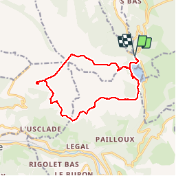
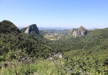
Balade à l'Est du Lac de Guéry, sur le plateau dominant le Mont Dore et La Bourboule. Départ sur le parking du lac de Guéry. Montée au Puy Loup, passage à la borne "des quatre Seigneurs", montée à la fameuse et incontournable banne d'Ordanche et le Puy Gros. Le retour au parking emprunte, sur le bord Est du lac, un chemin récemment aménagé par le Parc des Volcans. L'itinéraire est déconseillé par temps de brouillard et en hiver
Localización
Comentarios
Excursiones cerca
![Excursión Senderismo Orcival - Lac de Servières à partir du Café du Lac - Photo](https://media.geolcdn.com/t/375/260/d4f759b9-e870-4661-990b-869b6d13ddb5.jpeg&format=jpg&maxdim=2)
![Senderismo Senderismo](https://static1.geolcdn.com/sitytour/trail-icons/101.png)
Senderismo
![](/images/other/stat-length.png)
![](https://static1.geolcdn.com/siteimages/upload/files/16400158638029165_repeat_loop_refresh_sync_direction_icon.png)
![Senderismo Senderismo](https://static1.geolcdn.com/sitytour/trail-icons/101.png)
Senderismo
![](/images/other/stat-length.png)
![](https://static1.geolcdn.com/siteimages/upload/files/16400158638029165_repeat_loop_refresh_sync_direction_icon.png)
![Excursión Senderismo Orcival - boucle du Puy de l Ouire - Photo](https://media.geolcdn.com/t/375/260/acae3307-d0e9-457f-8795-cbbba2239bb1.jpg&format=jpg&maxdim=2)
![Senderismo Senderismo](https://static1.geolcdn.com/sitytour/trail-icons/101.png)
Senderismo
![](/images/other/stat-length.png)
![](https://static1.geolcdn.com/siteimages/upload/files/16400158638029165_repeat_loop_refresh_sync_direction_icon.png)
![Excursión Senderismo Mont-Dore - Le puy de la tache, le lacs servières et guèry par la cascade du Queureuilh depuis l'Escalidou. - Photo](https://media.geolcdn.com/t/375/260/ext.jpg?maxdim=2&url=https%3A%2F%2Fservices.sitytrail.com%2FGeolivesWS%2FDownloadMedia.ashx%3FTrailID%3D228422%26Media%3D20131022164253.jpg)
![Senderismo Senderismo](https://static1.geolcdn.com/sitytour/trail-icons/101.png)
Senderismo
![](/images/other/stat-length.png)
![](https://static1.geolcdn.com/siteimages/upload/files/16400158638029165_repeat_loop_refresh_sync_direction_icon.png)
![Excursión Senderismo Perpezat - quelques volcans - Photo](https://media.geolcdn.com/t/375/260/f39b4d03-1fff-4970-9dd3-3ef0b9b4dd15.jpg&format=jpg&maxdim=2)
![Senderismo Senderismo](https://static1.geolcdn.com/sitytour/trail-icons/101.png)
Senderismo
![](/images/other/stat-length.png)
![](https://static1.geolcdn.com/siteimages/upload/files/16400158638029165_repeat_loop_refresh_sync_direction_icon.png)
![Excursión Senderismo Chambon-sur-Lac - Puy de l'Angle 2740m 11.5.24 - Photo](https://media.geolcdn.com/t/375/260/5513db9c-349d-4f05-bc76-5b9d618ca52c.jpg&format=jpg&maxdim=2)
![Senderismo Senderismo](https://static1.geolcdn.com/sitytour/trail-icons/101.png)
Senderismo
![](/images/other/stat-length.png)
![](https://static1.geolcdn.com/siteimages/upload/files/16400158638029165_repeat_loop_refresh_sync_direction_icon.png)
![Excursión A pie Mont-Dore - Le Puy Gros - Photo](https://media.geolcdn.com/t/375/260/57e33af1-6a70-4dc9-a386-d267bcacc7aa.jpeg&format=jpg&maxdim=2)
![A pie A pie](https://static1.geolcdn.com/sitytour/trail-icons/100.png)
A pie
![](/images/other/stat-length.png)
![](https://static1.geolcdn.com/siteimages/upload/files/16400158638029165_repeat_loop_refresh_sync_direction_icon.png)
![Excursión A pie Murat-le-Quaire - La Banne d'Ordanche - Photo](https://media.geolcdn.com/t/375/260/5a160f99-3538-40cc-bcb6-e5deac233d03.jpeg&format=jpg&maxdim=2)
![A pie A pie](https://static1.geolcdn.com/sitytour/trail-icons/100.png)
A pie
![](/images/other/stat-length.png)
![](https://static1.geolcdn.com/siteimages/upload/files/16400158638029165_repeat_loop_refresh_sync_direction_icon.png)
![Excursión A pie Mont-Dore - Le plateau du Guery - Photo](https://media.geolcdn.com/t/375/260/eb535759-9ccf-4a0b-801d-efa2c6bfc3ac.jpeg&format=jpg&maxdim=2)
![A pie A pie](https://static1.geolcdn.com/sitytour/trail-icons/100.png)
A pie
![](/images/other/stat-length.png)
![](https://static1.geolcdn.com/siteimages/upload/files/16400158638029165_repeat_loop_refresh_sync_direction_icon.png)