![](/images/other/stat-length.png)
![Excursión Bici de montaña Cuges-les-Pins - Entre Cuges et Signes, la crête des Béguines - Photo](https://media.geolcdn.com/t/1900/400/ext.pjpeg?maxdim=2&url=https%3A%2F%2Fstatic1.geolcdn.com%2Fsiteimages%2Fupload%2Ffiles%2F1524743154velo.jpg)
Entre Cuges et Signes, la crête des Béguines
tracegps
Usuario
![Longitud](/images/other/stat-length.png)
![Altitud máxima](https://static1.geolcdn.com/siteimages/upload/files/1508320355ic_sort_altitude_max_24dp.png)
![Desnivel positivo](https://static1.geolcdn.com/siteimages/upload/files/1508320355ic_sort_den_pos_24dp.png)
![Km-Effort](/images/other/stat-length.png)
![Altitud mínima](https://static1.geolcdn.com/siteimages/upload/files/1508320355ic_sort_altitude_min_24dp.png)
![Desnivel negativo](https://static1.geolcdn.com/siteimages/upload/files/1508320355ic_sort_den_neg_24dp.png)
![Boucle](https://static1.geolcdn.com/siteimages/upload/files/16400158638029165_repeat_loop_refresh_sync_direction_icon.png)
![Bici de montaña](https://static1.geolcdn.com/sitytour/trail-icons/202.png)
8h00
Dificultad : Muy difícil
![Escanee este código QR para abrir la excursión en la aplicación SityTrail](https://capi.geolives.com/qq0zvz2zws4bq2lad0pu/sitytour/trails/105126/qr.png?size=200)
Aplicación GPS de excursión GRATIS
A propósito
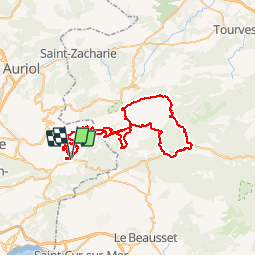
Ruta Bici de montaña de 66 km a descubrir en Provenza-Alpes-Costa Azul, Bocas del Ródano, Cuges-les-Pins. Esta ruta ha sido propuesta por tracegps.
Descripción
A la suite de mon très roulant circuit (Entre Cuges et Signes, le versant sud de la Sainte Baume), en voici une version "all mountain", avec du portage et des sentiers plus techniques (V5- en cotation VTOPO). Un magnifique parcours de crête bien roulant s'intercale entre une montée difficile (portage, mais aussi de très belles sections sur le vélo) et une longue descente soutenue. Le reste comporte beaucoup de parties très (trop pour certains? je les trouve personnellement bien agréables) roulantes, qui font de cet itinéraire un ensemble extrêmement varié et bien équilibré. Un crochet, malheureusement peu intéressant du point de vue du vtt, permet de traverser le site de Château Renard, la bastide des Romarins dans les films de Claude Berri, Jean de Florette et Manon des Sources. Veuillez respecter cette propriété (et aussi les autres, le Puits d'Arnaud en particulier) et soyez extrêmement discrets. On trouve un point d'eau potable à Riboux : petite station de pompage du groupe Eaux de Marseille, à côté de l'aire de pique-nique en face du village. L'eau des fontaines est signalée "non potable" à Cuges et "non traitée" à Signes, mais il y a des débits de boissons.
Localización
Comentarios
Excursiones cerca
![Excursión Senderismo Roquefort-la-Bédoule - Grand Caunet, le Montounier - Photo](https://media.geolcdn.com/t/375/260/6da96041-d8db-45b9-9840-88b8ee06ae33.jpg&format=jpg&maxdim=2)
![Senderismo Senderismo](https://static1.geolcdn.com/sitytour/trail-icons/101.png)
Senderismo
![](/images/other/stat-length.png)
![](https://static1.geolcdn.com/siteimages/upload/files/16400158638029165_repeat_loop_refresh_sync_direction_icon.png)
![Excursión Senderismo Roquefort-la-Bédoule - SityTrail - Grand Caunet, Cabanons, Vigie , Grotte Raymond, Ruines roquefort, Chapelle St andré - Photo](https://media.geolcdn.com/t/375/260/f9c0beb6-6483-4b14-ba76-b33fa5e2208b.jpg&format=jpg&maxdim=2)
![Senderismo Senderismo](https://static1.geolcdn.com/sitytour/trail-icons/101.png)
Senderismo
![](/images/other/stat-length.png)
![](https://static1.geolcdn.com/siteimages/upload/files/16400158638029165_repeat_loop_refresh_sync_direction_icon.png)
![Excursión Senderismo Le Castellet - SityTrail - 2361987 - begude - Photo](https://media.geolcdn.com/t/375/260/dbe90af6-979b-4145-807f-db327fb40379.jpg&format=jpg&maxdim=2)
![Senderismo Senderismo](https://static1.geolcdn.com/sitytour/trail-icons/101.png)
Senderismo
![](/images/other/stat-length.png)
![](https://static1.geolcdn.com/siteimages/upload/files/16400158638029165_repeat_loop_refresh_sync_direction_icon.png)
![Excursión Senderismo Gémenos - St Pons Le Fauge Glacière - Photo](https://media.geolcdn.com/t/375/260/ext.jpg?maxdim=2&url=https%3A%2F%2Fservices.sitytrail.com%2FGeolivesWS%2FDownloadMedia.ashx%3FTrailID%3D954893%26Media%3Dfix__20180430171638.jpg)
![Senderismo Senderismo](https://static1.geolcdn.com/sitytour/trail-icons/101.png)
Senderismo
![](/images/other/stat-length.png)
![](https://static1.geolcdn.com/siteimages/upload/files/16400158638029165_repeat_loop_refresh_sync_direction_icon.png)
![Excursión Senderismo Cuges-les-Pins - Jean de lorette, grotte et mémorial - Photo](https://media.geolcdn.com/t/375/260/7f0fa6ce-b146-4d44-9642-97b327cde2ed.jpg&format=jpg&maxdim=2)
![Senderismo Senderismo](https://static1.geolcdn.com/sitytour/trail-icons/101.png)
Senderismo
![](/images/other/stat-length.png)
![](https://static1.geolcdn.com/siteimages/upload/files/16400158638029165_repeat_loop_refresh_sync_direction_icon.png)
![Excursión Senderismo Gémenos - dent de roque forcade. cauvin.bertagne. 2 avril 2018 - Photo](https://media.geolcdn.com/t/375/260/ext.jpg?maxdim=2&url=https%3A%2F%2Fservices.sitytrail.com%2FGeolivesWS%2FDownloadMedia.ashx%3FTrailID%3D935467%26Media%3Dfix__20180402124207.jpg)
![Senderismo Senderismo](https://static1.geolcdn.com/sitytour/trail-icons/101.png)
Senderismo
![](/images/other/stat-length.png)
![](https://static1.geolcdn.com/siteimages/upload/files/16400158638029165_repeat_loop_refresh_sync_direction_icon.png)
![Excursión Senderismo Gémenos - autour de Saint pons - Photo](https://media.geolcdn.com/t/375/260/ext.jpg?maxdim=2&url=https%3A%2F%2Fservices.sitytrail.com%2FGeolivesWS%2FDownloadMedia.ashx%3FTrailID%3D723506%26Media%3Dfix__20170330154755.jpg)
![Senderismo Senderismo](https://static1.geolcdn.com/sitytour/trail-icons/101.png)
Senderismo
![](/images/other/stat-length.png)
![](https://static1.geolcdn.com/siteimages/upload/files/16400158638029165_repeat_loop_refresh_sync_direction_icon.png)
![Excursión Senderismo Gémenos - Autour des Dents de Roque Forcade, Tour de Cauvin - Photo](https://media.geolcdn.com/t/375/260/ext.jpg?maxdim=2&url=https%3A%2F%2Fservices.sitytrail.com%2FGeolivesWS%2FDownloadMedia.ashx%3FTrailID%3D107626%26Media%3D12610_1.jpg)
![Senderismo Senderismo](https://static1.geolcdn.com/sitytour/trail-icons/101.png)
Senderismo
![](/images/other/stat-length.png)
![](https://static1.geolcdn.com/siteimages/upload/files/16400158638029165_repeat_loop_refresh_sync_direction_icon.png)
![Excursión Bici de montaña Gémenos - Gémenos - La Grande Baume - Photo](https://media.geolcdn.com/t/375/260/ext.jpg?maxdim=2&url=https%3A%2F%2Fservices.sitytrail.com%2FGeolivesWS%2FDownloadMedia.ashx%3FTrailID%3D104196%26Media%3D7328_1.jpg)
![Bici de montaña Bici de montaña](https://static1.geolcdn.com/sitytour/trail-icons/202.png)
Bici de montaña
![](/images/other/stat-length.png)
![](https://static1.geolcdn.com/siteimages/upload/files/16400158638029165_repeat_loop_refresh_sync_direction_icon.png)